File:Deutsche Ostsiedlung.png
跳至導覽
跳至搜尋

預覽大小:449 × 599 像素。 其他解析度:180 × 240 像素 | 360 × 480 像素 | 576 × 768 像素 | 1,181 × 1,575 像素。
原始檔案 (1,181 × 1,575 像素,檔案大小:354 KB,MIME 類型:image/png)
說明
說明
添加單行說明來描述出檔案所代表的內容
摘要
[編輯]
| 描述 |
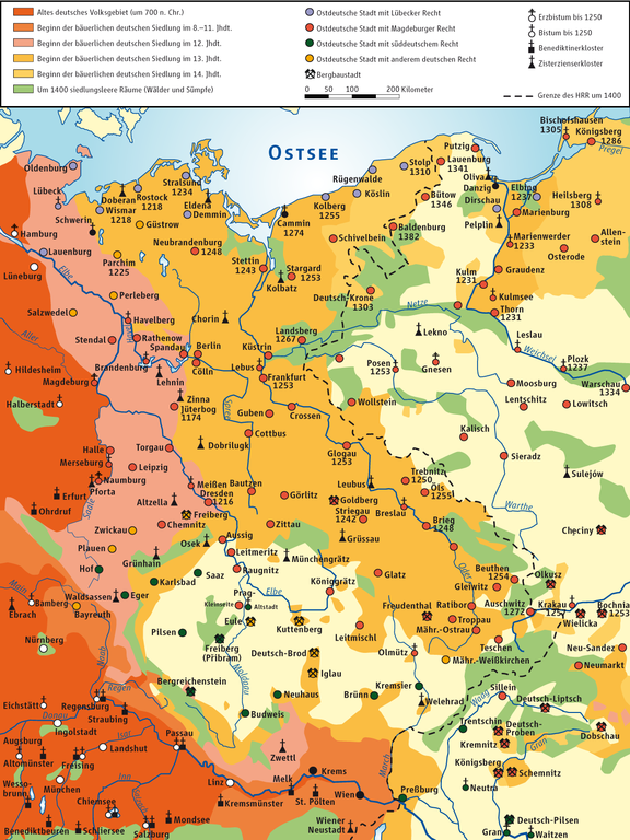
Deutsch: Karte der deutsche Ostkolonisation
English: Map of German Eastern settlement |
| 日期 | |
| 來源 |
自己的作品 based on Walter Kuhn: Die bäuerliche deutsche Ostsiedlung Source of Information: Putzger – Historischer Weltatlas (Jubiläumsausgabe); 85. Auflage, 1963, Velhagen & Klasing (Bielefeld u.a.), S. 54f; Putzger – Historischer Weltatlas, 89. Auflage, 1965; Westermanns Großer Atlas zur Weltgeschichte, 1969; Haacks geographischer Atlas. VEB Hermann Haack Geographisch-Kartographische Anstalt, Gotha/Leipzig, 1. Auflage, 1979; dtv-Atlas zur Weltgeschichte Band 1: Von den Anfängen bis zur Französischen Revolution; 23. Aufl. 1989, ISBN 3-423-03002-X. |
| 作者 | Ziegelbrenner |
| 其他版本 | File:Osadnictwo niemieckie na wschodzie.PNG |

|
|
授權條款
[編輯]
我,本作品的著作權持有者,決定用以下授權條款發佈本作品:

|
已授權您依據自由軟體基金會發行的無固定段落、封面文字和封底文字GNU自由文件授權條款1.2版或任意後續版本,對本檔進行複製、傳播和/或修改。該協議的副本列在GNU自由文件授權條款中。 |
此檔案採用創用CC 姓名標示-相同方式分享 3.0 未在地化版本授權條款。
- 您可以自由:
- 分享 – 複製、發佈和傳播本作品
- 重新修改 – 創作演繹作品
- 惟需遵照下列條件:
- 姓名標示 – 您必須指名出正確的製作者,和提供授權條款的連結,以及表示是否有對內容上做出變更。您可以用任何合理的方式來行動,但不得以任何方式表明授權條款是對您許可或是由您所使用。
- 相同方式分享 – 如果您利用本素材進行再混合、轉換或創作,您必須基於如同原先的相同或兼容的條款,來分布您的貢獻成品。
您可以選擇您需要的授權條款。
檔案歷史
點選日期/時間以檢視該時間的檔案版本。
| 日期/時間 | 縮圖 | 尺寸 | 使用者 | 備註 | |
|---|---|---|---|---|---|
| 目前 | 2014年2月15日 (六) 00:15 | | 1,181 × 1,575(354 KB) | Kopiersperre(留言 | 貢獻) | optipng |
| 2011年11月28日 (一) 14:53 |  | 1,181 × 1,575(600 KB) | Ziegelbrenner(留言 | 貢獻) | 2011-11-28 | |
| 2011年11月25日 (五) 12:13 |  | 1,181 × 1,575(595 KB) | Ziegelbrenner(留言 | 貢獻) | {{Information |Description ={{en|1=ddsvds}} {{de|1=dvdsvs}} |Source ={{own}} |Author =Ziegelbrenner |Date = |Permission ={{self|GFDL|cc-by-sa-3.0,2.5,2.0,1.0}} |other_versions =vdvdsv }} dvsdsvsdv |
無法覆蓋此檔案。
檔案用途
沒有使用此檔案的頁面。
全域檔案使用狀況
以下其他 wiki 使用了這個檔案:
- ar.wikipedia.org 的使用狀況
- cs.wikipedia.org 的使用狀況
- da.wikipedia.org 的使用狀況
- de.wikipedia.org 的使用狀況
- Geschichte Polens
- Hochmittelalterliche Ostsiedlung
- Umgebindehaus
- Deutsche Minderheit in Polen
- Schermützelsee
- Ostelbien
- Wikipedia:Kartenwerkstatt/Kartenwünsche
- Geschichte Mecklenburgs
- Entstehung der Mark Brandenburg
- Wikipedia:Kartenwerkstatt/Archiv/2011-11
- Benutzer:Weitzel S/artikel
- Benutzer:Mbauch/Artikel
- Benutzer:Cosmo26/Artikel
- Benutzer:Study23
- Benutzer:Eandré/Karten
- Benutzer:Ziegelbrenner/Meine Bilder auf Commons
- Benutzer:Volkmar Lehmann/Artikelentwurf
- Slawen in Deutschland
- Benutzer:Methodios/Sorbenprojekt
- Benutzer:Jmv/Farben/biene
- el.wikipedia.org 的使用狀況
- en.wikipedia.org 的使用狀況
- et.wikipedia.org 的使用狀況
- fa.wikipedia.org 的使用狀況
- he.wikipedia.org 的使用狀況
- it.wikipedia.org 的使用狀況
- ka.wikipedia.org 的使用狀況
- mk.wikipedia.org 的使用狀況
- nds-nl.wikipedia.org 的使用狀況
- nds.wikipedia.org 的使用狀況
- pl.wikipedia.org 的使用狀況
- ru.wikipedia.org 的使用狀況
- sk.wikipedia.org 的使用狀況
- sr.wikipedia.org 的使用狀況
- sv.wikipedia.org 的使用狀況
- tr.wikipedia.org 的使用狀況
- zh.wikipedia.org 的使用狀況