File:Diagram of Churchbridge Junction.svg
Jump to navigation
Jump to search

Size of this PNG preview of this SVG file: 400 × 260 pixels. Other resolutions: 320 × 208 pixels | 640 × 416 pixels | 1,024 × 666 pixels | 1,280 × 832 pixels | 2,560 × 1,664 pixels.
Original file (SVG file, nominally 400 × 260 pixels, file size: 6 KB)
Captions
Captions
Add a one-line explanation of what this file represents
Summary
[edit]
| Description |
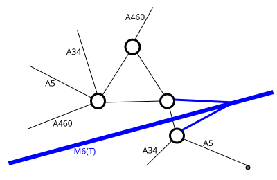
English: A diagram showing a simplified (i.e. showing only classified roads) layout of Churchbridge Junction |
| Date | |
| Source | Own work |
| Author | Fountainofignorance |
Licensing
[edit]
I, the copyright holder of this work, hereby publish it under the following licenses:

|
Permission is granted to copy, distribute and/or modify this document under the terms of the GNU Free Documentation License, Version 1.2 or any later version published by the Free Software Foundation; with no Invariant Sections, no Front-Cover Texts, and no Back-Cover Texts. A copy of the license is included in the section entitled GNU Free Documentation License. |
This file is licensed under the Creative Commons Attribution-Share Alike 3.0 Unported license.
- You are free:
- to share – to copy, distribute and transmit the work
- to remix – to adapt the work
- Under the following conditions:
- attribution – You must give appropriate credit, provide a link to the license, and indicate if changes were made. You may do so in any reasonable manner, but not in any way that suggests the licensor endorses you or your use.
- share alike – If you remix, transform, or build upon the material, you must distribute your contributions under the same or compatible license as the original.
You may select the license of your choice.
File history
Click on a date/time to view the file as it appeared at that time.
| Date/Time | Thumbnail | Dimensions | User | Comment | |
|---|---|---|---|---|---|
| current | 10:02, 9 November 2013 | | 400 × 260 (6 KB) | Fountainofignorance (talk | contribs) | I have corrected the defective line for the top part of the A460. Also cropped to remove excessive margins. |
| 23:28, 8 November 2013 |  | 640 × 480 (6 KB) | Fountainofignorance (talk | contribs) | {{subst:Upload marker added by en.wp UW}} {{Information |Description = {{en|A diagram showing a simplified (i.e. showing only classified roads) layout of Churchbridge Junction}} |Source = {{own}} |Date = 8 November 2013 |Author = [[User:Fountainofignor... |
You cannot overwrite this file.
File usage on Commons
There are no pages that use this file.
File usage on other wikis
The following other wikis use this file:
- Usage on en.wikipedia.org