File:Diagram of Passenger Rail in Connecticut.svg
Jump to navigation
Jump to search

Size of this PNG preview of this SVG file: 512 × 372 pixels. Other resolutions: 320 × 233 pixels | 640 × 465 pixels | 1,024 × 744 pixels | 1,280 × 930 pixels | 2,560 × 1,860 pixels.
Original file (SVG file, nominally 512 × 372 pixels, file size: 798 KB)
Captions
Captions
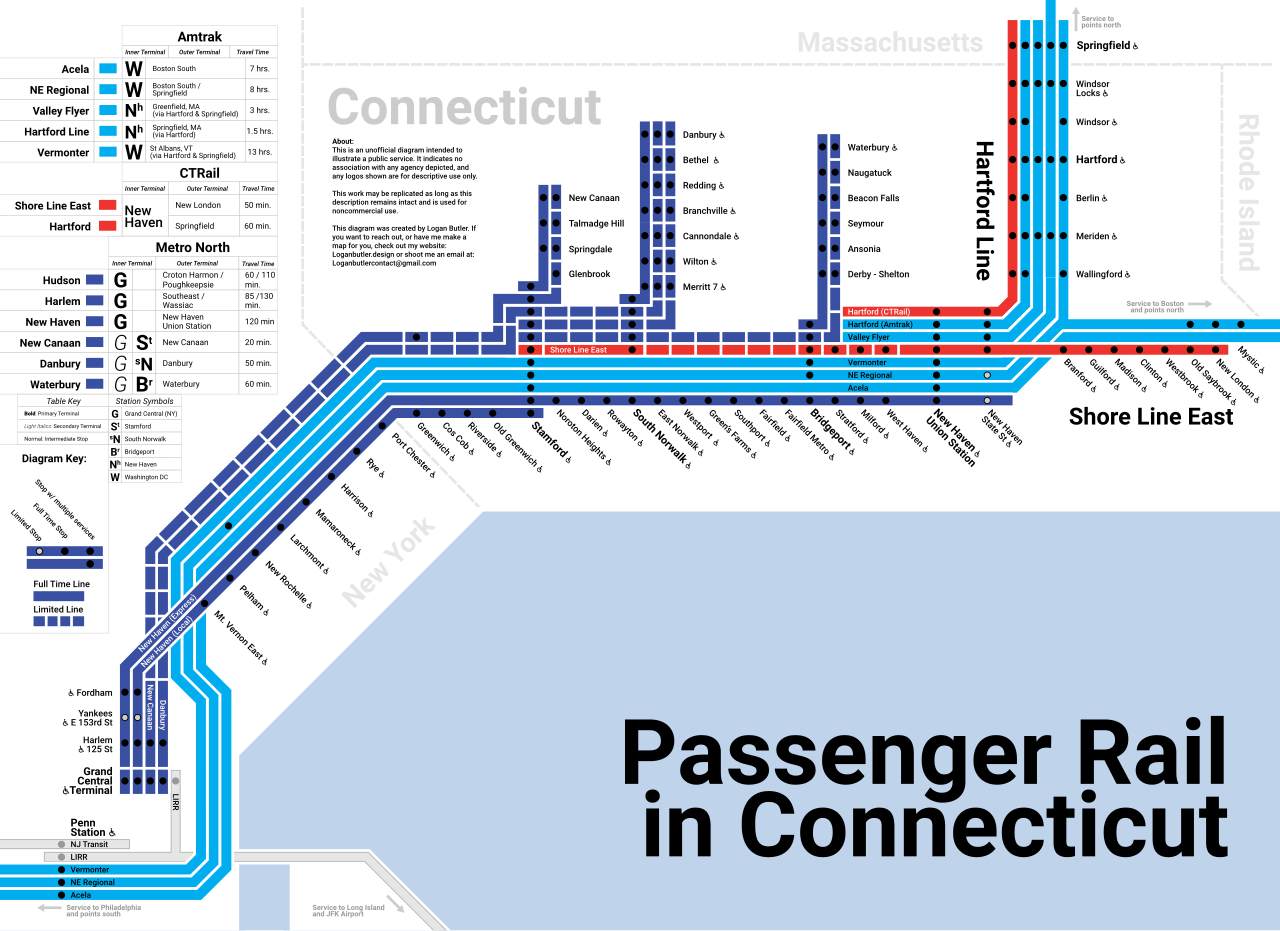
Diagram of all passenger rail in Connecticut , including Amtrak in light blue, Metro-North in dark blue, and CTRail in Red.
Summary
[edit]
| Description |
English: Diagram of all passenger rail in Connecticut , including Amtrak in light blue, Metro-North in dark blue, and CTRail in Red. |
| Date | |
| Source | Own work |
| Author | Loganbutler3 |
Licensing
[edit]
I, the copyright holder of this work, hereby publish it under the following license:
This file is licensed under the Creative Commons Attribution 4.0 International license.
- You are free:
- to share – to copy, distribute and transmit the work
- to remix – to adapt the work
- Under the following conditions:
- attribution – You must give appropriate credit, provide a link to the license, and indicate if changes were made. You may do so in any reasonable manner, but not in any way that suggests the licensor endorses you or your use.
File history
Click on a date/time to view the file as it appeared at that time.
| Date/Time | Thumbnail | Dimensions | User | Comment | |
|---|---|---|---|---|---|
| current | 00:25, 13 May 2024 | | 512 × 372 (798 KB) | Loganbutler3 (talk | contribs) | Minor Fixes |
| 01:52, 3 May 2024 |  | 512 × 372 (805 KB) | Loganbutler3 (talk | contribs) | Removed Corporate Logos | |
| 01:44, 3 May 2024 |  | 512 × 372 (807 KB) | Loganbutler3 (talk | contribs) | Uploaded own work with UploadWizard |
You cannot overwrite this file.
File usage on Commons
The following 7 pages use this file:
- User:Chumwa/OgreBot/Public transport information/2024 May 1-10
- User:Chumwa/OgreBot/Public transport information/2024 May 11-20
- User:Chumwa/OgreBot/Transport Maps/2024 May 1-10
- User:Chumwa/OgreBot/Transport Maps/2024 May 11-20
- User:Chumwa/OgreBot/Travel and communication maps/2024 May 1-10
- User:Chumwa/OgreBot/Travel and communication maps/2024 May 11-20
- User:GeorgR (de)/Rail Transport in the US/2024 May
File usage on other wikis
The following other wikis use this file:
- Usage on de.wikipedia.org