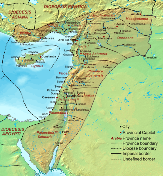
File:Dioecesis Orientis 400 AD.png
از Wikimedia Commons
پرش به ناوبری
پرش به جستجو

اندازهٔ این پیشنمایش: ۵۵۴ × ۶۰۰ پیکسل. کیفیتهای دیگر: ۲۲۲ × ۲۴۰ پیکسل | ۶۲۰ × ۶۷۱ پیکسل.
پروندهٔ اصلی (۶۲۰ × ۶۷۱ پیکسل، اندازهٔ پرونده: ۳۷۳ کیلوبایت، نوع MIME پرونده: image/png)
اطلاعات پرونده
دادههای ساختاریافته
گزینهها
عنوان
شرحی یکخطی از محتوای این فایل اضافه کنید
the Levant (in Latin) or Syria (in Greek) or AlSham (in Arabic/Semitic)
خلاصه[ویرایش]
| توضیحDioecesis Orientis 400 AD.png | Map of the Diocese of the East (Dioecesis Orientis) ca. 400 AD, showing the subordinate provinces and the major cities. |
| تاریخ | |
| منبع |
Base map found at en:Topographic map#Global 1-kilometer map, otherwise self-made. Data based on maps in atlases and the internet and on contemporary sources, primarily the Notitia Dignitatum and the Synecdemus. Note: the exact course of the provincial boundaries is very uncertain and in many cases only approximate. |
| پدیدآور | Cplakidas |
اجازهنامه[ویرایش]
| Public domainPublic domainfalsefalse |
| من، دارنده حق تکثیر این اثر، این اثر را به مالکیت عمومی منتشر میکنم. این قابل اجرا در تمام نقاط جهان است. در برخی از کشورها ممکن است به صورت قانونی این امکانپذیر نباشد؛ اگر چنین است: من اجازهٔ استفاده از این اثر را برای هر مقصودی، بدون هیچگونه شرایطی میدهم، تا وقتی که این شرایط توسط قانون مستلزم نشده باشد. |
تاریخچهٔ پرونده
روی تاریخ/زمانها کلیک کنید تا نسخهٔ مربوط به آن هنگام را ببینید.
| تاریخ/زمان | بندانگشتی | ابعاد | کاربر | توضیح | |
|---|---|---|---|---|---|
| کنونی | ۱۹ سپتامبر ۲۰۰۷، ساعت ۱۷:۴۸ |  | ۶۲۰ در ۶۷۱ (۳۷۳ کیلوبایت) | Cplakidas (بحث | مشارکتها) | {{Information |Description=Map of the en:Diocese of the East (''Dioecesis Orientis'') ca. 400 AD, showing the subordinate provinces and the major cities. |Source=Base map found at en:Topographic map#Global 1-kilometer map, otherwise self-made. |
شما نمیتوانید این پرونده را رونویسی کنید.
کاربرد پرونده
صفحههای زیر از این تصویر استفاده میکنند:
کاربرد سراسری پرونده
ویکیهای دیگر زیر از این پرونده استفاده میکنند:
- کاربرد در ar.wikipedia.org
- کاربرد در ast.wikipedia.org
- کاربرد در azb.wikipedia.org
- کاربرد در ba.wikipedia.org
- کاربرد در be.wikipedia.org
- کاربرد در bg.wikipedia.org
- کاربرد در bn.wikipedia.org
- کاربرد در br.wikipedia.org
- کاربرد در ca.wikipedia.org
- کاربرد در cy.wikipedia.org
- کاربرد در de.wikipedia.org
- کاربرد در el.wikipedia.org
- کاربرد در en.wikipedia.org
- Decapolis
- Orient
- Bilad al-Sham
- Arab Christians
- Coele-Syria
- Al-Harith ibn Jabalah
- Antiochia ad Cragum
- Limes Arabicus
- List of revolutions and rebellions
- Mesopotamia (Roman province)
- Diocese of the East
- History of the Roman Empire
- History of Palestine
- Syria Prima
- Al-Mundhir III ibn al-Harith
- History of the Romans in Arabia
- Samaritan revolts
- Euphratensis
- Palaestina Salutaris
- Classical Anatolia
- Transjordan (region)
نمایش استفادههای سراسری از این پرونده.