File:Disastrous floods in Brazil.jpg

Original file (4,407 × 2,541 pixels, file size: 5.17 MB, MIME type: image/jpeg)
Captions
Captions
Summary
[edit]
| Description |
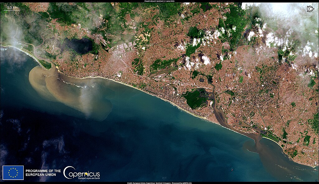
English: Heavy rains lashed north-eastern Brazil last week, triggering multiple landslides on Friday 27 May 2022. The local population was heavily affected: as of 2 June, 120 causalities have been reported and more than 7,300 people have been left homeless. Operations to track down missing people are still ongoing and heavy rains are forecasted to further affect the region. This image, acquired on 1 June 2022 by one of the Copernicus Sentinel-2 satellites, shows the significant river discharge caused by the heavy rains near Recife in the State of Pernambuco, one of the most severely affected areas. Deadly flooding and mudslides have already affected Brazil over the past year: in February, more than 100 people were killed in Petropolis, in the State of Rio de Janeiro. Climate change is widely believed to contribute to more intense rainfall, and the Intergovernmental Panel on Climate Change has classified Recife’s metropolitan region as one of the world’s most vulnerable urban areas. Copernicus data and services are key to monitoring flooding events and assessing their consequences. For example, the Emergency Response Coordination Centre (ERCC) of the Directorate-General for European Civil Protection and Humanitarian Aid (DG ECHO) has published this map of the ongoing Brazilian floods and landslides. It was produced using the Global Human Settlement Layer (GHSL) product of the Copernicus Emergency Management Service (CEMS). |
| Date | Taken on 1 June 2022 |
| Source | Disastrous floods in Brazil |
| Author | European Union, Copernicus Sentinel-2 imagery |
Licensing
[edit]

|
This image contains data from a satellite in the Copernicus Programme, such as Sentinel-1, Sentinel-2 or Sentinel-3. Attribution is required when using this image.
Attribution: Contains modified Copernicus Sentinel data 2022
The use of Copernicus Sentinel Data is regulated under EU law (Commission Delegated Regulation (EU) No 1159/2013 and Regulation (EU) No 377/2014). Relevant excerpts:
Free access shall be given to GMES dedicated data [...] made available through GMES dissemination platforms [...].
Access to GMES dedicated data [...] shall be given for the purpose of the following use in so far as it is lawful:
GMES dedicated data [...] may be used worldwide without limitations in time.
GMES dedicated data and GMES service information are provided to users without any express or implied warranty, including as regards quality and suitability for any purpose. |
File history
Click on a date/time to view the file as it appeared at that time.
| Date/Time | Thumbnail | Dimensions | User | Comment | |
|---|---|---|---|---|---|
| current | 16:32, 20 August 2023 | | 4,407 × 2,541 (5.17 MB) | OptimusPrimeBot (talk | contribs) | #Spacemedia - Upload of https://www.copernicus.eu/system/files/2022-06/image_day/20220603_FloodsBrazil_0.jpg via Commons:Spacemedia |
You cannot overwrite this file.
File usage on Commons
There are no pages that use this file.