File:Djerba Island.jpeg
Jump to navigation
Jump to search

Size of this preview: 600 × 600 pixels. Other resolutions: 240 × 240 pixels | 480 × 480 pixels | 768 × 768 pixels | 1,024 × 1,024 pixels | 2,333 × 2,333 pixels.
Original file (2,333 × 2,333 pixels, file size: 3.86 MB, MIME type: image/jpeg)
Captions
Captions
Add a one-line explanation of what this file represents
Summary
[edit]
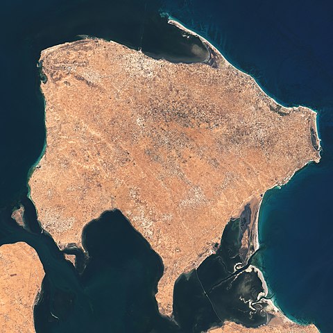
| Description | The Operational Land Imager (OLI) on Landsat 8 acquired these natural-color images of Ajim on May 4, 2020. |
| Date | |
| Source | https://earthobservatory.nasa.gov/images/146772/a-falcon-over-ajim |
| Author | NASA Earth Observatory images by Lauren Dauphin, using Landsat data from the U.S. Geological Survey. Story by Adam Voiland. |
Licensing
[edit]
| This file is in the public domain in the United States because it was solely created by NASA. NASA copyright policy states that "NASA material is not protected by copyright unless noted". (See Template:PD-USGov, NASA copyright policy page or JPL Image Use Policy.) | ||
 |
Warnings:
|
File history
Click on a date/time to view the file as it appeared at that time.
| Date/Time | Thumbnail | Dimensions | User | Comment | |
|---|---|---|---|---|---|
| current | 02:39, 26 May 2021 | | 2,333 × 2,333 (3.86 MB) | StellarHalo (talk | contribs) | {{Information |Description=The Operational Land Imager (OLI) on Landsat 8 acquired these natural-color images of Ajim on May 4, 2020. |Source=https://earthobservatory.nasa.gov/images/146772/a-falcon-over-ajim |Date=4 May 2020 |Author=NASA Earth Observatory images by Lauren Dauphin, using Landsat data from the U.S. Geological Survey. Story by Adam Voiland. |Permission= |other_versions= }} Category:Satellite pictures by Landsat 8 Category:Satellite pictures of Tunisia Category:Djerba |
You cannot overwrite this file.
File usage on Commons
There are no pages that use this file.
File usage on other wikis
The following other wikis use this file:
- Usage on en.wikipedia.org
- Usage on fi.wikipedia.org
- Usage on fr.wikipedia.org
- Usage on mt.wikipedia.org
- Usage on pl.wikipedia.org
- Usage on si.wikipedia.org
- Usage on th.wikipedia.org