File:Doha, Qatar.JPG

原始檔案 (2,850 × 4,288 像素,檔案大小:2.91 MB,MIME 類型:image/jpeg)
說明
說明
摘要[編輯]
| 描述 |
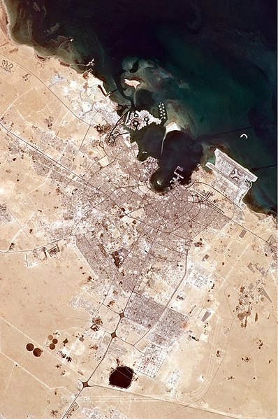
English: The old and new zones of Doha, the capital city of Qatar, are clearly visible from the International Space Station. The old city comprises the ancient bazaar, or Souq, near the dhow harbor, which is still used today for traditional Arab sailing vessels. Modern port facilities have sprung up to the east of the Souq.
Subsequent developments have sprouted progressively further from the ancient center, with ring roads concentrically arranged around it. The diplomatic quarter is reached via the waterfront Corniche promenade, north of the old city. Further away, an extensive marina known as West Bay Lagoon, with boating access to the Persian Gulf, stands out (image top). Qatar’s new artificial island, known as the Pearl-Qatar, is under construction with 32 kilometres of new coastline just offshore of West Bay Lagoon. This development is intended mainly as a residential zone, with themes based on Arabic, Mediterranean, and European cultures. The Pearl-Qatar is so named because it is being built on one of Qatar’s historical pearl diving sites. A string of small islands built along the outer margin is intended to recall the pearl-diving culture of the nation’s past. When compared to maps of the proposed project, the basic outline of the islands appears to be substantially complete. The distance from the entry causeway to the end of the string of small islands is 5 kilometres in a straight line. This image also shows the network of deep access channels—marked by darker blue water—leading to The Pearl-Qatar and West Bay Lagoon. The population of Qatar is almost 1.7 million, with nearly 75 percent being migrant workers from south and south-east Asia. Ninety percent of Qatari citizens live in Doha. Qatar enjoys vast hydrocarbon wealth, thanks to the third largest gas reserves in the world. Consequently, the emirate has one of the highest per capita gross domestic products (GDP) in the world. Qataris are known to be cricket, tennis, and soccer enthusiasts. On December 2, 2010, Qatar won the bid to host the 2022 FIFA World Cup. An underground soccer (football) stadium is being built, the first of its kind. The existing sports complex is based at the Khalifa Stadium, visible to the south-west of the city. |
| 日期 | |
| 來源 | NASA Earth Observatory |
| 作者 | ISS Expedition 25 crew |
| 拍攝地點 | | 位於此地的本圖片與其他圖片: OpenStreetMap |
|---|
本圖像或影音收錄於美國國家航空暨太空總署 (NASA)休士頓太空中心(Johnson Space Center),其照片編號為: ISS025-E-6121 此標籤不表示文件的著作權狀態。任何文件在附有此標籤的同時還需要一個有效的著作權標籤。請參閱許可協議說明頁面以了解更多資訊。 其他語言:
|
Image acquired with a Nikon D2Xs digital camera using an 180 mm lens, and is provided by the ISS Crew Earth Observations experiment and Image Science & Analysis Laboratory, Johnson Space Center.
授權條款[編輯]
| 本作品由NASA創作,屬於公有領域。根據NASA的版權政策:“NASA的創作除非另有聲明否則不受版權保護。”(參見:Template:PD-USGov/zh,NASA版權政策或JPL圖像使用政策) | ||
 |
警告:
|
| 註解 | 該圖片含有註解:在維基媒體共享資源上查看註解 |
檔案歷史
點選日期/時間以檢視該時間的檔案版本。
| 日期/時間 | 縮圖 | 尺寸 | 使用者 | 備註 | |
|---|---|---|---|---|---|
| 目前 | 2010年12月20日 (一) 11:35 | | 2,850 × 4,288(2.91 MB) | Originalwana(留言 | 貢獻) | {{Information |Description={{en|1=The old and new zones of Doha, the capital city of Qatar, are clearly visible from the International Space Station. The old city comprises the ancient bazaar, or Souq, near the dhow harbor, which is still used today f |
無法覆蓋此檔案。
檔案用途
下列頁面有用到此檔案:
全域檔案使用狀況
以下其他 wiki 使用了這個檔案:
- azb.wikipedia.org 的使用狀況
- ca.wikipedia.org 的使用狀況
- da.wikipedia.org 的使用狀況
- en.wikipedia.org 的使用狀況
- es.wikipedia.org 的使用狀況
- kn.wikipedia.org 的使用狀況
- nl.wikipedia.org 的使用狀況
- nn.wikipedia.org 的使用狀況
- pt.wikipedia.org 的使用狀況
- ro.wikipedia.org 的使用狀況
- ru.wikipedia.org 的使用狀況
- th.wikipedia.org 的使用狀況
- vi.wikipedia.org 的使用狀況
- zh.wikipedia.org 的使用狀況