File:Dolnoslaskie mapa administracyjna.png
Jump to navigation
Jump to search

Size of this preview: 661 × 600 pixels. Other resolutions: 265 × 240 pixels | 529 × 480 pixels | 846 × 768 pixels | 1,128 × 1,024 pixels | 2,507 × 2,275 pixels.
Original file (2,507 × 2,275 pixels, file size: 796 KB, MIME type: image/png)
Captions
Captions
Add a one-line explanation of what this file represents
Summary
[edit]
| Description |
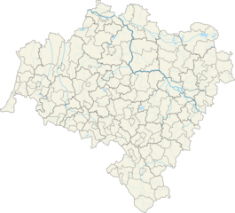
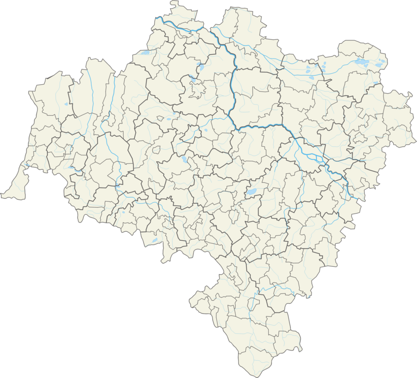
Polski: Województwo dolnośląskie – powiaty i gminy Współrzędne graniczne mapy:
|
| Date | |
| Source | Own work |
| Author | Aotearoa |
Licensing
[edit]
I, the copyright holder of this work, hereby publish it under the following license:
This file is licensed under the Creative Commons Attribution 3.0 Unported license.
- You are free:
- to share – to copy, distribute and transmit the work
- to remix – to adapt the work
- Under the following conditions:
- attribution – You must give appropriate credit, provide a link to the license, and indicate if changes were made. You may do so in any reasonable manner, but not in any way that suggests the licensor endorses you or your use.
File history
Click on a date/time to view the file as it appeared at that time.
| Date/Time | Thumbnail | Dimensions | User | Comment | |
|---|---|---|---|---|---|
| current | 13:38, 26 October 2012 | | 2,507 × 2,275 (796 KB) | Aotearoa (talk | contribs) | User created page with UploadWizard |
You cannot overwrite this file.
File usage on Commons
There are no pages that use this file.
File usage on other wikis
The following other wikis use this file:
- Usage on be.wikipedia.org
- Уроцлаў
- Лягніца
- Міліч
- Любань (Ніжнесілезскае ваяводства)
- Валбжых
- Яленя Гура
- Любін
- Свідніца
- Хойнаў
- Болькаў
- Барда (Польшча)
- Бярутаў
- Глогаў
- Бжэг Дольны
- Хацянаў
- Баляславец
- Мірск
- Улень
- Любомеж
- Ельч-Ляскавіцы
- Алава (Польшча)
- Грыфаў Слёнскі
- Шаблон:На карце/Польшча Ніжнесілезскае ваяводства
- Алясніца
- Волаў
- Гура (горад)
- Палькавіцы
- Львовак Слёнскі
- Сьрода Слёнска
- Каменна Гура
- Замбкавіцы Слёнске
- Дзяржонеў
- Клодзка
- Стшэлін
- Явар (горад)
- Тшэбніца
- Згажэлец
- Златарыя
- Кудова-Здруй
- Паляніца-Здруй
- Душнікі-Здруй
- Нова Руда
- Быстшыца Клодзка
- Шчытна (Ніжнесілезскае ваяводства)
- Строне Слёнске
- Радкаў (горад)
- Лёндак-Здруй
- Мендзылессе
- Шклярска Парэмба
- Кавары
View more global usage of this file.