File:Dominee Charles Chais, Carte du Premier age, ou Situation du Iardin d'Eden et du Mont Ararat ou l'Arche s'arreta apres le deluge (FL45612065 3957204).jpg
Jump to navigation
Jump to search
Size of this preview: 672 × 600 pixels. Other resolutions: 269 × 240 pixels | 538 × 480 pixels | 860 × 768 pixels | 1,147 × 1,024 pixels | 2,294 × 2,048 pixels | 3,321 × 2,965 pixels.
Original file (3,321 × 2,965 pixels, file size: 2.56 MB, MIME type: image/jpeg)
Captions
Captions
Add a one-line explanation of what this file represents
Summary
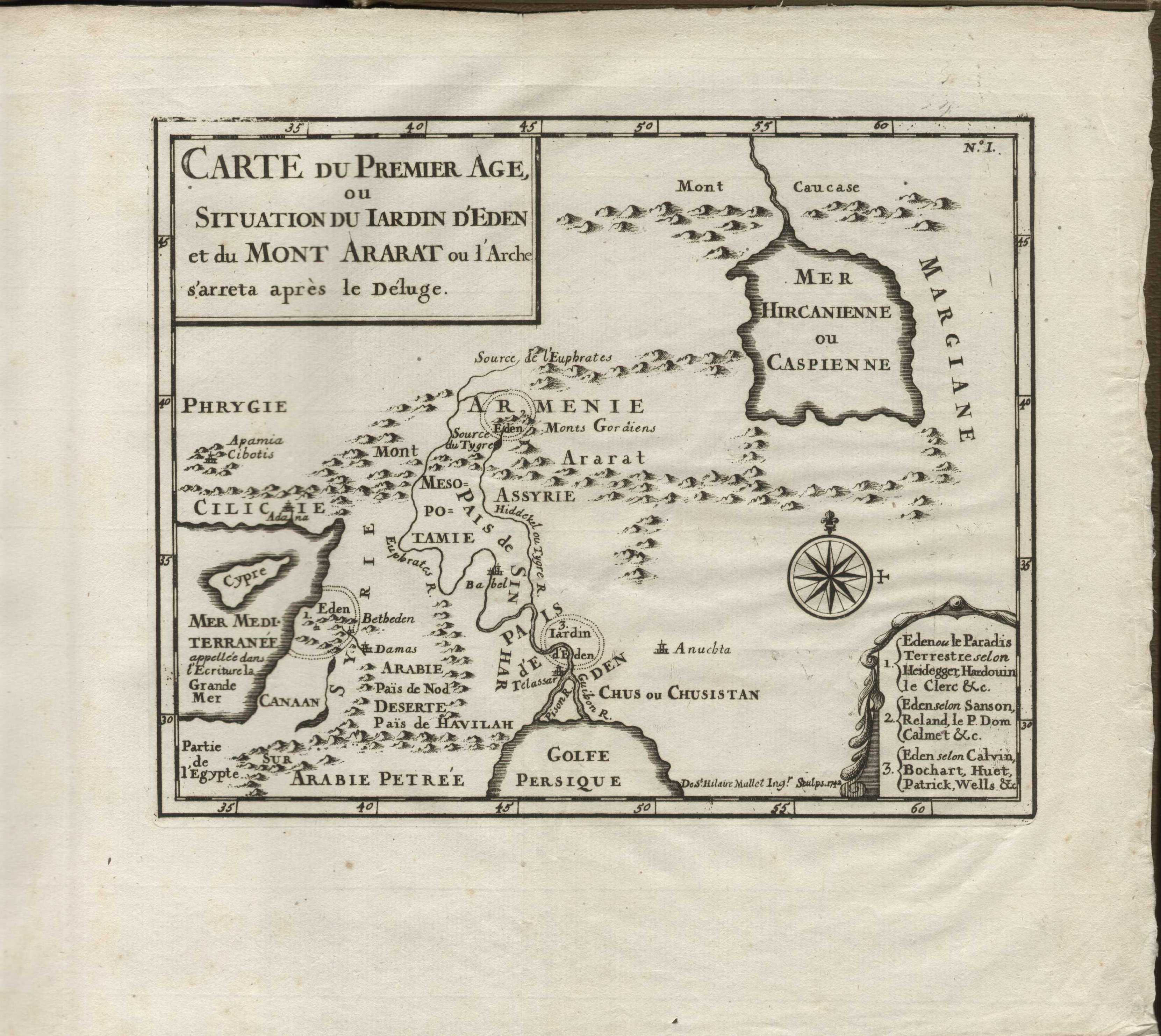
[edit]| Dominee Charles Chais: Carte du Premier age, ou Situation du Iardin d'Eden et du Mont Ararat ou l'Arche s'arreta apres le deluge
( |
||||||||||||||||||||||||
|---|---|---|---|---|---|---|---|---|---|---|---|---|---|---|---|---|---|---|---|---|---|---|---|---|
| Artist |
|
|||||||||||||||||||||||
| Title |
Carte du Premier age, ou Situation du Iardin d'Eden et du Mont Ararat ou l'Arche s'arreta apres le deluge |
|||||||||||||||||||||||
| Publisher |
Pierre Paupie |
|||||||||||||||||||||||
| Description |
Carte du Premier age, ou Situation du Iardin d'Eden et du Mont Ararat ou l'Arche s'arreta apres le deluge. De St. Hilaire Mallet Ingr. Sculps. 1742. |
|||||||||||||||||||||||
| Language | French | |||||||||||||||||||||||
| Publication date | 1743 | |||||||||||||||||||||||
| Medium | 1 online resource (1 map). | |||||||||||||||||||||||
| Collection |
|
|||||||||||||||||||||||
| Current location |
|
|||||||||||||||||||||||
| Place of publication | France | |||||||||||||||||||||||
| search Merhav catalog | France | |||||||||||||||||||||||
| Notes | Digital image of the original in Amir Cahanovitc Collection, Israel. ACC 2462-1.; Digital image received from donor.; From: La sainte bible, ou le vieux et le nouveau testament; avec un commentaire littéral, composé de notes choisies & tirées de divers auteurs anglois. Tome premier. | |||||||||||||||||||||||
| IE PID | IE45612063 | |||||||||||||||||||||||
| Rosetta filename | FL45612065 | |||||||||||||||||||||||
| NNL item ID (P3959) | 990039572040205171 | |||||||||||||||||||||||
| search Merhav catalog | French, Dominee Charles Chais | |||||||||||||||||||||||
| search Merhav catalog | EdenMapsPierre Paupie | |||||||||||||||||||||||
| Source/Photographer |
|
|||||||||||||||||||||||
| Other versions | ||||||||||||||||||||||||
| Jpg / Tif version |
|
|||||||||||||||||||||||
_-_C1507_-_Cultural_Heritage_Agency_of_the_Netherlands_Art_Collection.jpg)

.jpg)

.jpg&action=edit§ion=1)
Licensing
[edit].jpg&action=edit§ion=2)
The copyright situation of this work is theoretically uncertain, because in the country of origin copyright lasts 70 years after the death of the author, and the date of the author's death is unknown. However, the date of creation of the work was over 120 years ago, and it is thus a reasonable assumption that the copyright has expired (see here for the community discussion). Do not use this template if the date of death of the author is known.
| |
| This file has been identified as being free of known restrictions under copyright law, including all related and neighboring rights. | |
File history
Click on a date/time to view the file as it appeared at that time.
| Date/Time | Thumbnail | Dimensions | User | Comment | |
|---|---|---|---|---|---|
| current | 22:56, 3 September 2023 | | 3,321 × 2,965 (2.56 MB) | Geagea (talk | contribs) | pattypan 22.03 |
You cannot overwrite this file.
File usage on Commons
The following page uses this file:
.jpg&oldid=798621158)