File:Dominion of Pakistan & Indian Controlled Kashmir (orthographic projection).svg
Siirry navigaatioon
Siirry hakuun

Tämän PNG-esikatselun koko koskien SVG-tiedostoa: 541 × 541 kuvapistettä. Muut resoluutiot: 240 × 240 kuvapistettä | 480 × 480 kuvapistettä | 768 × 768 kuvapistettä | 1 024 × 1 024 kuvapistettä | 2 048 × 2 048 kuvapistettä.
Alkuperäinen tiedosto (SVG-tiedosto; oletustarkkuus 541 × 541 kuvapistettä; tiedostokoko 396 KiB)
Kuvatekstit
Kuvatekstit
Lisää yhden rivin pituinen kuvaus tästä tiedostosta
Yhteenveto
[muokkaa]| Kuvaus |
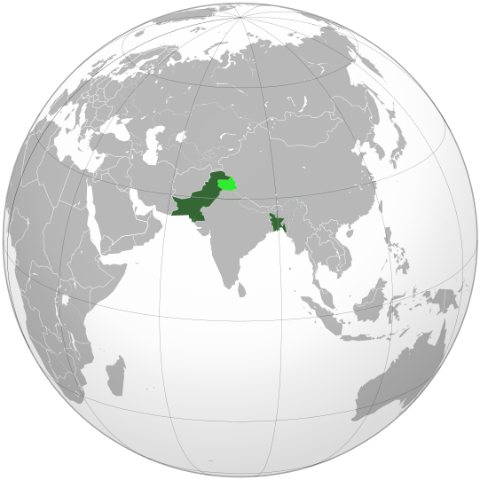
English: Dominion of Pakistan is highlighted in dark green and Indian Controlled Kashmir in light green. This map shows the borders of every countries, political entities and other territories between July 2006 to June 2011, which makes a big mistake. Here is the reason: Dominion of Pakistan existed from 14 August 1947, when it became independent from British India, to 23 March 1956, when it was succeeded by Islamic Republic of Pakistan. Thus, this map should show the borders of every countries, political entities, colonies and other territories at the end of 1955 (see the English Wikipedia articles "List of sovereign states in 1955" and "List of national border changes since World War I"). हिन्दी: पाकिस्तान अधिराज्य अधीन भूमि को गाढ़े हरे रंग में रेखांकित किया गया है, वहीँ भारत शासित कश्मीर हलके हरे रंग में है |
| Päiväys | Sunday 31 May 2009 (01:06 GMT+1) |
| Lähde | Oma teos |
| Tekijä | SelfQ |
| Muut versiot |
.svg) |
.svg)
.svg)
.svg)
.svg)
.svg)
.svg)
.svg)
.svg)
.svg)
.svg)
.svg)
.svg)
.svg)
.svg)
.svg)
.svg)
.svg)
.svg)
.svg)
.svg)
.svg)
.svg)
.svg)
.svg)
.svg)
.svg)
.svg)
.svg)
.svg)
.svg)
.svg)
.svg)
.svg)
.svg)
.svg)
.svg)
.svg)
.svg)
.svg)
.svg)
.svg)
.svg)
.svg)
.svg)
.svg)
.svg)
.svg)
.svg)
.svg)
.svg)
.svg)
.svg)
.svg)
.svg)
.svg)
.svg)
.svg)
.svg)
.svg)
.svg)
.svg)
.svg)
.svg)
.svg)
.svg)
.svg)
.svg)
.svg)
.svg)
.svg)
.svg)
.svg)
.svg)

.svg)

.svg)

.svg)
.svg)
.svg)
.svg)
.svg)
.svg)
.svg)


.svg)
.svg)
.svg)
.svg)
.svg)
.svg)
.svg)

.svg)
.svg)
.svg)
.svg)
.svg)
.svg)
.svg)
.svg)
.svg)
.svg)

.svg)
.svg)
.svg)
.svg)
.svg)
.svg)
.svg)
_without_national_boundaries.svg)
.svg)
.svg)
.svg)
.svg)
.svg)
.svg)

.svg)
.svg)
.png)
.svg)
.svg)
.svg)
.svg)

.svg)
.svg)
.svg)
.svg)
.svg)
.svg)
.svg)
.svg)
.svg)
.svg)
.svg)

.svg)
.svg)
.svg)
.svg)
.svg)
.svg)
.svg)
.svg)
.svg)

.svg)
.svg)

.svg)
.svg)
.svg)
.svg)
.svg)
.svg)
.svg)
.svg)
.svg)
.svg)
.svg)
.svg)
.svg)
.svg)
.svg)
.svg)
.svg)
.svg)
.svg)
.svg)
.svg)
.svg)
.svg)
.svg)
.svg)
.svg)
.svg)
_-_Crimea_disputed.svg)
.svg)
.svg)
.svg)
.svg)
.svg)
.svg)
.svg)
.svg)
.svg)
.svg)
.svg)
_political.svg)
.svg)
.svg)
.svg)
.svg)
_-_Crimea_disputed_-_no_borders.svg)
.svg)
.svg)
.svg)
.svg)
.svg)
.svg)
.svg)
.svg)
.svg)
.svg)
.svg)

.svg)
.svg)
.svg)

.png)
.svg)
.svg)
.svg)
.svg)
.svg)
.svg)
.svg)
.svg)
.svg)
.svg)
.svg)
.svg)
.svg)
.svg)
.svg)
.svg)
.svg)
.svg)
.svg)
.svg)
.svg)
.svg)
.svg)
.svg)
.svg)
.svg)
.svg)
.svg)
.svg)
.svg)
.svg)
.svg)
.svg)
.svg)
.png)
.svg)
.svg)
.svg)
_(orthographic_projection).png)
.svg&action=edit§ion=1)
Lisenssi
[muokkaa].svg&action=edit§ion=2)
Minä, tämän teoksen tekijänoikeuksien haltija, julkaisen täten tämän teoksen seuraavilla lisensseillä:
Tämä tiedosto on lisensoitu Creative Commons Nimeä-JaaSamoin 3.0 Ei sovitettu -lisenssillä.
- Voit:
- jakaa – kopioida, levittää ja esittää teosta
- remiksata – valmistaa muutettuja teoksia
- Seuraavilla ehdoilla:
- nimeäminen – Sinun on mainittava lähde asianmukaisesti, tarjottava linkki lisenssiin sekä merkittävä, mikäli olet tehnyt muutoksia. Voit tehdä yllä olevan millä tahansa kohtuullisella tavalla, mutta et siten, että annat ymmärtää lisenssinantajan suosittelevan sinua tai teoksen käyttöäsi.
- jaa samoin – Jos muutat tai perustat tähän työhön, voit jakaa tuloksena syntyvää työtä vain tällä tai tämän kaltaisella lisenssillä.

|
Voit kopioida, levittää ja/tai muuttaa tätä asiakirjaa GNU Free Documentation License -lisenssin version 1.2 tai minkä tahansa Free Software Foundationin julkaiseman myöhemmän version ehtojen alaisena; ei koske muuttumattomia kohtia, etukannen tekstejä eikä takakannen tekstejä. Kopio tästä lisenssistä on saatavilla osiossa GNU Free Documentation License. |
Voit valita haluamasi lisenssin.
Tiedoston historia
Päiväystä napsauttamalla näet, millainen tiedosto oli kyseisellä hetkellä.
| Päiväys | Pienoiskuva | Koko | Käyttäjä | Kommentti | |
|---|---|---|---|---|---|
| nykyinen | 29. heinäkuuta 2020 kello 14.15 | | 541 × 541 (396 KiB) | Hogweard (keskustelu | muokkaukset) | Set the borders to 1955 |
| 19. joulukuuta 2019 kello 15.54 |  | 541 × 541 (339 KiB) | Goran tek-en (keskustelu | muokkaukset) | Added border for South Sudan as requested by {{u|Maphobbyist}} | |
| 30. toukokuuta 2009 kello 23.08 |  | 541 × 541 (548 KiB) | SelfQ~commonswiki (keskustelu | muokkaukset) | {{Information |Description=Location of the Dominion of Pakistan, also include Jammu and Kashmir (in light green), which is disputed by Pakistan, though it currently part of India. |Source=self-made |Date=Sunday 31 May 2009 (01:06 GMT+1) |Author= [[User:Se |
Et voi tallentaa uutta tiedostoa tämän tilalle.
Tiedoston käyttö
Enemmän kuin 100 sivua linkittävät tähän tiedostoon. Seuraava lista näyttää 100 ensimmäistä sivua, jotka käyttävät vain tätä tiedostoa. Koko lista on saatavilla.
.svg)
- Grey–green orthographic projections maps
- User:Heraldry/Projections
- User:SelfQ~commonswiki/Gallery
- User:Ssolbergj/orthographic
- File:ALBA (orthographic projection).png
- File:Africa (orthographic projection).svg
- File:African Union (orthographic projection).svg
- File:Almoravid map.svg
- File:America do Sul (orthographic projection).jpg
- File:Americas (orthographic projection).svg
- File:Andean Community (orthographic projection).svg
- File:Antarctica (orthographic projection).svg
- File:Antillas (orthographic projection).svg
- File:Arctic (orthographic projection).svg
- File:Argentina (orthographic projection).png
- File:Argentina (orthographic projection).svg
- File:Aridoamerica (orthographic projection).svg
- File:Armenia (orthographic projection).svg
- File:Asia (orthographic projection).svg
- File:Association of Southeast Asian Nations (orthographic projection).svg
- File:Australia-New Guinea (orthographic projection).svg
- File:Australia (orthographic projection).svg
- File:Australia map with outlying islands.svg
- File:Bhutan (orthographic projection).svg
- File:Brazil (orthographic projection).svg
- File:CECAFA-Map.svg
- File:Canada (orthographic projection).svg
- File:Cape Verde (orthographic projection).svg
- File:Captaincy General of Chile (orthographic projection).svg
- File:Central America (orthographic projection).svg
- File:Central Asia (orthographic projection).svg
- File:Chile (orthographic projection).svg
- File:Colombia (orthographic projection).svg
- File:Democratic Republic of the Congo (orthographic projection).svg
- File:Dominion of Pakistan & Indian Controlled Kashmir (orthographic projection).svg
- File:Dominion of Pakistan (orthographic projection).svg (tiedosto-ohjaus)
- File:East Asia (orthographic projection).svg
- File:Ecuador (orthographic projection).svg
- File:Europe (orthographic projection).svg
- File:European Union (orthographic projection).svg
- File:Federal Republic of Central America (orthographic projection).svg
- File:First Brazilian Empire (orthographic projection).svg
- File:First Mexican Empire (orthographic projection).svg
- File:Georgia (orthographic projection).svg
- File:Germany (orthographic projection).svg
- File:Global European Union.svg
- File:Great Colombia (orthographic projection).svg
- File:Greater Middle East (orthographic projection).svg
- File:Haiti (orthographic projection).svg
- File:India (orthographic projection).svg
- File:Indonesia (orthographic projection).svg
- File:Iran (orthographic projection).svg
- File:Iraq (orthographic projection).svg
- File:Jamaica (orthographic projection).svg
- File:Japan (orthographic projection).svg
- File:Kazakhstan (orthographic projection).svg
- File:Latin America (orthographic projection).svg
- File:Lusophone America (orthographic projection).svg
- File:MERCOSUR (orthographic projection).svg
- File:Madagascar (orthographic projection).svg
- File:Maghreb (orthographic projection).svg
- File:Malaysia (orthographic projection).svg
- File:Mayan languages (orthographic projection).svg
- File:Mesoamerica (orthographic projection) with borders.svg
- File:Mexico (orthographic projection).svg
- File:Mexico and Central America (orthographic projection).svg
- File:Middle East (orthographic projection).svg
- File:Mongolia (orthographic projection).svg
- File:New Spain (orthographic projection).svg
- File:New Zealand (orthographic projection).svg
- File:Nigeria (orthographic projection).svg
- File:North Africa (orthographic projection).svg
- File:North America (orthographic projection).svg
- File:North American Agreement (orthographic projection).svg
- File:North Korea (orthographic projection).svg
- File:Papua New Guinea (orthographic projection).svg
- File:Paraguay (orthographic projection).svg
- File:People's Republic of China (orthographic projection).svg
- File:Peru (orthographic projection).svg
- File:Peru–Bolivia Confederation (orthographic projection).svg
- File:Philippines (orthographic projection).svg
- File:Republic of Artsakh (orthographic projection).svg
- File:Republic of China (orthographic projection).svg
- File:Rio Group (orthographic projection).svg
- File:Roman Empire (orthographic projection).svg
- File:Russian Federation (orthographic projection).svg
- File:Second Mexican Empire (orthographic projection).svg
- File:South Asia (orthographic projection) without national boundaries.svg
- File:South Korea (orthographic projection).svg
- File:Southern Europe (orthographic projection).svg
- File:Tawantinsuyu (orthographic projection).svg
- File:The Philippines and ASEAN (orthographic projection).svg
- File:Third Reich (orthographic projection).svg
- File:Tunisia (orthographic projection).svg
- File:Turkey (orthographic projection).svg
- File:Union of South American Nations (orthographic projection).svg
- File:Union of Soviet Socialist Republics (orthographic projection).svg
- File:United Provinces of Central America (orthographic projection).svg
- File:Venezuela (orthographic projection).svg
- File:Viceroyalty of Peru (orthographic projection).svg
.png)
.svg)
.jpg)
.svg)
.svg)
.png)
.svg)
.svg)
.svg)
.svg)
.svg&redirect=no)
.svg)
.svg)
.svg)
.svg)
_with_borders.svg)
.svg)
.svg)
.svg)
.svg)
.svg)
.svg)
.svg)
Näytä lisää linkkejä tähän tiedostoon.
Tiedoston järjestelmänlaajuinen käyttö
Seuraavat muut wikit käyttävät tätä tiedostoa:
- Käyttö kohteessa ar.wikipedia.org
- Käyttö kohteessa ast.wikipedia.org
- Käyttö kohteessa az.wikipedia.org
- Käyttö kohteessa be.wikipedia.org
- Käyttö kohteessa bg.wikipedia.org
- Käyttö kohteessa bn.wikipedia.org
- Käyttö kohteessa ca.wikipedia.org
- Käyttö kohteessa cs.wikipedia.org
- Käyttö kohteessa el.wikipedia.org
- Käyttö kohteessa en.wikipedia.org
- Käyttö kohteessa eo.wikipedia.org
- Käyttö kohteessa es.wikipedia.org
- Käyttö kohteessa eu.wikipedia.org
- Käyttö kohteessa fa.wikipedia.org
- Käyttö kohteessa fi.wikipedia.org
- Käyttö kohteessa fr.wikipedia.org
- Käyttö kohteessa he.wikipedia.org
- Käyttö kohteessa hi.wikipedia.org
- Käyttö kohteessa id.wikipedia.org
- Käyttö kohteessa it.wikipedia.org
- Käyttö kohteessa ja.wikipedia.org
- Käyttö kohteessa ko.wikipedia.org
- Käyttö kohteessa ks.wikipedia.org
- Käyttö kohteessa ms.wikipedia.org
- Käyttö kohteessa mt.wikipedia.org
- Käyttö kohteessa ne.wikipedia.org
- Käyttö kohteessa nl.wikipedia.org
- Käyttö kohteessa pl.wikipedia.org
- Käyttö kohteessa pt.wikipedia.org
- Käyttö kohteessa ru.wikipedia.org
- Käyttö kohteessa simple.wikipedia.org
- Käyttö kohteessa sv.wikipedia.org
- Käyttö kohteessa tg.wikipedia.org
- Käyttö kohteessa th.wikipedia.org
- Käyttö kohteessa uk.wikipedia.org
- Käyttö kohteessa ur.wikipedia.org
- Käyttö kohteessa uz.wikipedia.org
Näytä lisää tämän tiedoston järjestelmänlaajuista käyttöä.
.svg)
.svg&oldid=747647220)