File:Dominion of Pakistan & Indian Controlled Kashmir (orthographic projection).svg
跳转到导航
跳转到搜索

此SVG文件的PNG预览的大小:541 × 541像素。 其他分辨率:240 × 240像素 | 480 × 480像素 | 768 × 768像素 | 1,024 × 1,024像素 | 2,048 × 2,048像素。
原始文件 (SVG文件,尺寸为541 × 541像素,文件大小:396 KB)
说明
说明
添加一行文字以描述该文件所表现的内容
摘要
[编辑]| 描述 |
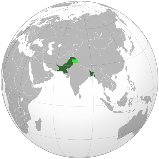
English: Dominion of Pakistan is highlighted in dark green and Indian Controlled Kashmir in light green. This map shows the borders of every countries, political entities and other territories between July 2006 to June 2011, which makes a big mistake. Here is the reason: Dominion of Pakistan existed from 14 August 1947, when it became independent from British India, to 23 March 1956, when it was succeeded by Islamic Republic of Pakistan. Thus, this map should show the borders of every countries, political entities, colonies and other territories at the end of 1955 (see the English Wikipedia articles "List of sovereign states in 1955" and "List of national border changes since World War I"). हिन्दी: पाकिस्तान अधिराज्य अधीन भूमि को गाढ़े हरे रंग में रेखांकित किया गया है, वहीँ भारत शासित कश्मीर हलके हरे रंग में है |
| 日期 | Sunday 31 May 2009 (01:06 GMT+1) |
| 来源 | 自己的作品 |
| 作者 | SelfQ |
| 其他版本 |
.svg) |
.svg)
.svg)
.svg)
.svg)
.svg)
.svg)
.svg)
.svg)
.svg)
.svg)
.svg)
.svg)
.svg)
.svg)
.svg)
.svg)
.svg)
.svg)
.svg)
.svg)
.svg)
.svg)
.svg)
.svg)
.svg)
.svg)
.svg)
.svg)
.svg)
.svg)
.svg)
.svg)
.svg)
.svg)
.svg)
.svg)
.svg)
.svg)
.svg)
.svg)
.svg)
.svg)
.svg)
.svg)
.svg)
.svg)
.svg)
.svg)
.svg)
.svg)
.svg)
.svg)
.svg)
.svg)
.svg)
.svg)
.svg)
.svg)
.svg)
.svg)
.svg)
.svg)
.svg)
.svg)
.svg)
.svg)
.svg)
.svg)
.svg)
.svg)
.svg)
.svg)
.svg)

.svg)

.svg)

.svg)
.svg)
.svg)
.svg)
.svg)
.svg)
.svg)


.svg)
.svg)
.svg)
.svg)
.svg)
.svg)
.svg)

.svg)
.svg)
.svg)
.svg)
.svg)
.svg)
.svg)
.svg)
.svg)
.svg)

.svg)
.svg)
.svg)
.svg)
.svg)
.svg)
.svg)
_without_national_boundaries.svg)
.svg)
.svg)
.svg)
.svg)
.svg)
.svg)

.svg)
.svg)
.png)
.svg)
.svg)
.svg)
.svg)

.svg)
.svg)
.svg)
.svg)
.svg)
.svg)
.svg)
.svg)
.svg)
.svg)
.svg)

.svg)
.svg)
.svg)
.svg)
.svg)
.svg)
.svg)
.svg)
.svg)

.svg)
.svg)

.svg)
.svg)
.svg)
.svg)
.svg)
.svg)
.svg)
.svg)
.svg)
.svg)
.svg)
.svg)
.svg)
.svg)
.svg)
.svg)
.svg)
.svg)
.svg)
.svg)
.svg)
.svg)
.svg)
.svg)
.svg)
.svg)
.svg)
_-_Crimea_disputed.svg)
.svg)
.svg)
.svg)
.svg)
.svg)
.svg)
.svg)
.svg)
.svg)
.svg)
.svg)
_political.svg)
.svg)
.svg)
.svg)
.svg)
_-_Crimea_disputed_-_no_borders.svg)
.svg)
.svg)
.svg)
.svg)
.svg)
.svg)
.svg)
.svg)
.svg)
.svg)
.svg)

.svg)
.svg)
.svg)

.png)
.svg)
.svg)
.svg)
.svg)
.svg)
.svg)
.svg)
.svg)
.svg)
.svg)
.svg)
.svg)
.svg)
.svg)
.svg)
.svg)
.svg)
.svg)
.svg)
.svg)
.svg)
.svg)
.svg)
.svg)
.svg)
.svg)
.svg)
.svg)
.svg)
.svg)
.svg)
.svg)
.svg)
.svg)
.png)
.svg)
.svg)
.svg)
_(orthographic_projection).png)
.svg&action=edit§ion=1)
许可协议
[编辑].svg&action=edit§ion=2)
我,本作品著作权人,特此采用以下许可协议发表本作品:
本文件采用知识共享署名-相同方式共享 3.0 未本地化版本许可协议授权。
- 您可以自由地:
- 共享 – 复制、发行并传播本作品
- 修改 – 改编作品
- 惟须遵守下列条件:
- 署名 – 您必须对作品进行署名,提供授权条款的链接,并说明是否对原始内容进行了更改。您可以用任何合理的方式来署名,但不得以任何方式表明许可人认可您或您的使用。
- 相同方式共享 – 如果您再混合、转换或者基于本作品进行创作,您必须以与原先许可协议相同或相兼容的许可协议分发您贡献的作品。

|
已授权您依据自由软件基金会发行的无固定段落及封面封底文字(Invariant Sections, Front-Cover Texts, and Back-Cover Texts)的GNU自由文件许可协议1.2版或任意后续版本的条款,复制、传播和/或修改本文件。该协议的副本请见“GNU Free Documentation License”。 |
您可以选择您需要的许可协议。
文件历史
点击某个日期/时间查看对应时刻的文件。
| 日期/时间 | 缩略图 | 大小 | 用户 | 备注 | |
|---|---|---|---|---|---|
| 当前 | 2020年7月29日 (三) 14:15 | | 541 × 541(396 KB) | Hogweard(留言 | 贡献) | Set the borders to 1955 |
| 2019年12月19日 (四) 15:54 |  | 541 × 541(339 KB) | Goran tek-en(留言 | 贡献) | Added border for South Sudan as requested by {{u|Maphobbyist}} | |
| 2009年5月30日 (六) 23:08 |  | 541 × 541(548 KB) | SelfQ~commonswiki(留言 | 贡献) | {{Information |Description=Location of the Dominion of Pakistan, also include Jammu and Kashmir (in light green), which is disputed by Pakistan, though it currently part of India. |Source=self-made |Date=Sunday 31 May 2009 (01:06 GMT+1) |Author= [[User:Se |
您不可以覆盖此文件。
文件用途
超过100个页面使用本文件。 下面的列表只显示使用本文件的前100个页面。完整列表可用。
.svg)
- Grey–green orthographic projections maps
- User:Heraldry/Projections
- User:SelfQ~commonswiki/Gallery
- User:Ssolbergj/orthographic
- File:ALBA (orthographic projection).png
- File:Africa (orthographic projection).svg
- File:African Union (orthographic projection).svg
- File:Almoravid map.svg
- File:America do Sul (orthographic projection).jpg
- File:Americas (orthographic projection).svg
- File:Andean Community (orthographic projection).svg
- File:Antarctica (orthographic projection).svg
- File:Antillas (orthographic projection).svg
- File:Arctic (orthographic projection).svg
- File:Argentina (orthographic projection).png
- File:Argentina (orthographic projection).svg
- File:Aridoamerica (orthographic projection).svg
- File:Armenia (orthographic projection).svg
- File:Asia (orthographic projection).svg
- File:Association of Southeast Asian Nations (orthographic projection).svg
- File:Australia-New Guinea (orthographic projection).svg
- File:Australia (orthographic projection).svg
- File:Australia map with outlying islands.svg
- File:Bhutan (orthographic projection).svg
- File:Brazil (orthographic projection).svg
- File:CECAFA-Map.svg
- File:Canada (orthographic projection).svg
- File:Cape Verde (orthographic projection).svg
- File:Captaincy General of Chile (orthographic projection).svg
- File:Central America (orthographic projection).svg
- File:Central Asia (orthographic projection).svg
- File:Chile (orthographic projection).svg
- File:Colombia (orthographic projection).svg
- File:Democratic Republic of the Congo (orthographic projection).svg
- File:Dominion of Pakistan & Indian Controlled Kashmir (orthographic projection).svg
- File:Dominion of Pakistan (orthographic projection).svg(文件重定向)
- File:East Asia (orthographic projection).svg
- File:Ecuador (orthographic projection).svg
- File:Europe (orthographic projection).svg
- File:European Union (orthographic projection).svg
- File:Federal Republic of Central America (orthographic projection).svg
- File:First Brazilian Empire (orthographic projection).svg
- File:First Mexican Empire (orthographic projection).svg
- File:Georgia (orthographic projection).svg
- File:Germany (orthographic projection).svg
- File:Global European Union.svg
- File:Great Colombia (orthographic projection).svg
- File:Greater Middle East (orthographic projection).svg
- File:Haiti (orthographic projection).svg
- File:India (orthographic projection).svg
- File:Indonesia (orthographic projection).svg
- File:Iran (orthographic projection).svg
- File:Iraq (orthographic projection).svg
- File:Jamaica (orthographic projection).svg
- File:Japan (orthographic projection).svg
- File:Kazakhstan (orthographic projection).svg
- File:Latin America (orthographic projection).svg
- File:Lusophone America (orthographic projection).svg
- File:MERCOSUR (orthographic projection).svg
- File:Madagascar (orthographic projection).svg
- File:Maghreb (orthographic projection).svg
- File:Malaysia (orthographic projection).svg
- File:Mayan languages (orthographic projection).svg
- File:Mesoamerica (orthographic projection) with borders.svg
- File:Mexico (orthographic projection).svg
- File:Mexico and Central America (orthographic projection).svg
- File:Middle East (orthographic projection).svg
- File:Mongolia (orthographic projection).svg
- File:New Spain (orthographic projection).svg
- File:New Zealand (orthographic projection).svg
- File:Nigeria (orthographic projection).svg
- File:North Africa (orthographic projection).svg
- File:North America (orthographic projection).svg
- File:North American Agreement (orthographic projection).svg
- File:North Korea (orthographic projection).svg
- File:Papua New Guinea (orthographic projection).svg
- File:Paraguay (orthographic projection).svg
- File:People's Republic of China (orthographic projection).svg
- File:Peru (orthographic projection).svg
- File:Peru–Bolivia Confederation (orthographic projection).svg
- File:Philippines (orthographic projection).svg
- File:Republic of Artsakh (orthographic projection).svg
- File:Republic of China (orthographic projection).svg
- File:Rio Group (orthographic projection).svg
- File:Roman Empire (orthographic projection).svg
- File:Russian Federation (orthographic projection).svg
- File:Second Mexican Empire (orthographic projection).svg
- File:South Asia (orthographic projection) without national boundaries.svg
- File:South Korea (orthographic projection).svg
- File:Southern Europe (orthographic projection).svg
- File:Tawantinsuyu (orthographic projection).svg
- File:The Philippines and ASEAN (orthographic projection).svg
- File:Third Reich (orthographic projection).svg
- File:Tunisia (orthographic projection).svg
- File:Turkey (orthographic projection).svg
- File:Union of South American Nations (orthographic projection).svg
- File:Union of Soviet Socialist Republics (orthographic projection).svg
- File:United Provinces of Central America (orthographic projection).svg
- File:Venezuela (orthographic projection).svg
- File:Viceroyalty of Peru (orthographic projection).svg
.png)
.svg)
.jpg)
.svg)
.svg)
.png)
.svg)
.svg)
.svg)
.svg)
.svg&redirect=no)
.svg)
.svg)
.svg)
.svg)
_with_borders.svg)
.svg)
.svg)
.svg)
.svg)
.svg)
.svg)
.svg)
查看连接到这个文件的更多链接。
全域文件用途
以下其他wiki使用此文件:
- ar.wikipedia.org上的用途
- ast.wikipedia.org上的用途
- az.wikipedia.org上的用途
- be.wikipedia.org上的用途
- bg.wikipedia.org上的用途
- bn.wikipedia.org上的用途
- ca.wikipedia.org上的用途
- cs.wikipedia.org上的用途
- el.wikipedia.org上的用途
- en.wikipedia.org上的用途
- eo.wikipedia.org上的用途
- es.wikipedia.org上的用途
- eu.wikipedia.org上的用途
- fa.wikipedia.org上的用途
- fi.wikipedia.org上的用途
- fr.wikipedia.org上的用途
- he.wikipedia.org上的用途
- hi.wikipedia.org上的用途
- id.wikipedia.org上的用途
- it.wikipedia.org上的用途
- ja.wikipedia.org上的用途
- ko.wikipedia.org上的用途
- ks.wikipedia.org上的用途
- ms.wikipedia.org上的用途
- mt.wikipedia.org上的用途
- ne.wikipedia.org上的用途
- nl.wikipedia.org上的用途
- pl.wikipedia.org上的用途
- pt.wikipedia.org上的用途
- ru.wikipedia.org上的用途
- simple.wikipedia.org上的用途
- sv.wikipedia.org上的用途
- tg.wikipedia.org上的用途
- th.wikipedia.org上的用途
- uk.wikipedia.org上的用途
查看此文件的更多全域用途。
.svg)
.svg&oldid=747647220)