File:Douglas County Georgia Winston Highlighted.png
(Redirected from File:Douglas County Georgia Winston Highlighted.svg.png)
No higher resolution available.
Douglas_County_Georgia_Winston_Highlighted.png (250 × 184 pixels, file size: 35 KB, MIME type: image/png)
Captions
Captions
Add a one-line explanation of what this file represents
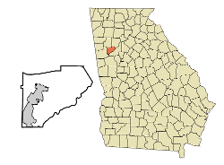
| Description | This map shows the unincorporated area, Winston, in Douglas County, Georgia, highlighted in red. It was edited using GIMP using an original image created with a custom script with US Census Bureau data and modified with Inkscape. |
| Date | (UTC) |
| Source | |
| Author |
| This is a retouched picture, which means that it has been digitally altered from its original version. Modifications: Replaced Douglasville and Unincorporated Areas in Douglas County, GA with the unincorporated area of Winston, GA. The original can be viewed here: Douglas County Georgia Incorporated and Unincorporated areas Douglasville Highlighted.svg:
|
I, the copyright holder of this work, hereby publish it under the following licenses:
This file is licensed under the Creative Commons Attribution-Share Alike 2.5 Generic, 2.0 Generic and 1.0 Generic license.
- You are free:
- to share – to copy, distribute and transmit the work
- to remix – to adapt the work
- Under the following conditions:
- attribution – You must give appropriate credit, provide a link to the license, and indicate if changes were made. You may do so in any reasonable manner, but not in any way that suggests the licensor endorses you or your use.
- share alike – If you remix, transform, or build upon the material, you must distribute your contributions under the same or compatible license as the original.
| This file is licensed under the Creative Commons Attribution-Share Alike 3.0 Unported license. | ||
| ||
| This licensing tag was added to this file as part of the GFDL licensing update. |

|
Permission is granted to copy, distribute and/or modify this document under the terms of the GNU Free Documentation License, Version 1.2 or any later version published by the Free Software Foundation; with no Invariant Sections, no Front-Cover Texts, and no Back-Cover Texts. A copy of the license is included in the section entitled GNU Free Documentation License. |
You may select the license of your choice.
Original upload log[edit]
This image is a derivative work of the following images:
- File:Douglas_County_Georgia_Incorporated_and_Unincorporated_areas_Douglasville_Highlighted.svg licensed with Cc-by-sa-2.5,2.0,1.0, Cc-by-sa-3.0-migrated, GFDL
- 2007-09-19T20:46:53Z ArkyBot 750x550 (203164 Bytes) {{Information |Description=This map shows the [[:en:Municipality|incorporated]] and unincorporated areas in [[:en:Douglas County, Georgia|Douglas County]], [[:en:Georgia|Georgia]], highlighting [[:w:Douglasville, Georgia|
Uploaded with derivativeFX
File history
Click on a date/time to view the file as it appeared at that time.
| Date/Time | Thumbnail | Dimensions | User | Comment | |
|---|---|---|---|---|---|
| current | 06:40, 29 November 2010 | | 250 × 184 (35 KB) | Jonslate~commonswiki (talk | contribs) | {{Information |Description=This map shows the unincorporated area, Winston, in Douglas County, Georgia, highlighted in red. It was edited using GIMP using an original image created w |
You cannot overwrite this file.
File usage on Commons
The following 2 pages use this file:
File usage on other wikis
The following other wikis use this file:
- Usage on azb.wikipedia.org
- Usage on en.wikipedia.org
- Usage on fa.wikipedia.org
- Usage on www.wikidata.org
- Usage on zh.wikipedia.org