File:Dozois 77.07W 47.46N.jpg
跳转到导航
跳转到搜索

本预览的尺寸:740 × 599像素。 其他分辨率:296 × 240像素 | 593 × 480像素 | 1,016 × 823像素。
原始文件 (1,016 × 823像素,文件大小:265 KB,MIME类型:image/jpeg)
说明
说明
添加一行文字以描述该文件所表现的内容
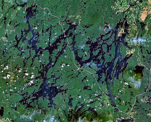
| 描述 | Reservoir Dozois, Quebec, Canada. Quebec Route 117 is also visible running from north to south in the centre of the image. |
| 来源 | NASA WorldWind |
| 作者 | NASA |
| 本圖像屬於公有領域,因其為NASA的World Wind衛星地圖瀏覽器的一張截圖,且使用了公有領域圖層,如Blue Marble、MODIS、Landsat、SRTM、USGS、GLOBE等。
|
 |
文件历史
点击某个日期/时间查看对应时刻的文件。
| 日期/时间 | 缩略图 | 大小 | 用户 | 备注 | |
|---|---|---|---|---|---|
| 当前 | 2008年10月7日 (二) 13:52 | | 1,016 × 823(265 KB) | P199(留言 | 贡献) | {{Information |Description=Reservoir Dozois, Quebec, Canada |Source=NASA WorldWind |Date= |Author=NASA |Permission= |other_versions= }} {{PD-WorldWind}} Category:Reservoirs of Quebec |
您不可以覆盖此文件。
文件用途
没有页面使用本文件。
全域文件用途
以下其他wiki使用此文件:
- bg.wikipedia.org上的用途
- ceb.wikipedia.org上的用途
- de.wikipedia.org上的用途
- en.wikipedia.org上的用途
- es.wikipedia.org上的用途
- fr.wikipedia.org上的用途
- www.wikidata.org上的用途
- zh.wikipedia.org上的用途