File:Drought Mitigation Decision Support System.png
Jump to navigation
Jump to search
No higher resolution available.
Drought_Mitigation_Decision_Support_System.png (650 × 442 pixels, file size: 30 KB, MIME type: image/png)
Captions
Captions
Add a one-line explanation of what this file represents
Summary
[edit]
| Description |
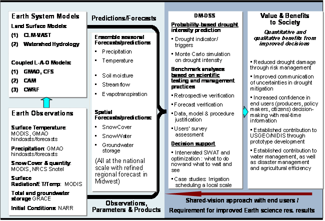
English: The goal of this project is to develop seasonal predictive capacity for the Drought Monitor-Decision Support System (DM-DSS), using Earth science models and satellite products. The DM-DSS was produced jointly by several national institutes, led by the National Drought Mitigation Center ( NDMC ) at the University of Nebraska-Lincoln. The Monitor presents a single, easy-to-read color map that summarizes current information from numerous drought indices and indicators. The enhanced DM-DSS with a predictive capacity will allow society's response to a drought from a traditional "crisis management" scenario, which emphasizes emergency response, to a "risk management" approach, which places greater emphasis on preparedness planning and mitigation actions. |
| Date | Last Modified: 04/15/09 |
| Source | http://wmp.gsfc.nasa.gov/projects/project_DroughtSeasPred.php |
| Author | NASA |
Licensing
[edit]
| This file is in the public domain in the United States because it was solely created by NASA. NASA copyright policy states that "NASA material is not protected by copyright unless noted". (See Template:PD-USGov, NASA copyright policy page or JPL Image Use Policy.) | ||
 |
Warnings:
|
File history
Click on a date/time to view the file as it appeared at that time.
| Date/Time | Thumbnail | Dimensions | User | Comment | |
|---|---|---|---|---|---|
| current | 11:33, 17 June 2009 | | 650 × 442 (30 KB) | Mdd (talk | contribs) | {{Information |Description={{en|1=The goal of this project is to develop seasonal predictive capacity for the Drought Monitor-Decision Support System (DM-DSS), using Earth science models and satellite products. The DM-DSS was produced jointly by several n |
You cannot overwrite this file.
File usage on Commons
There are no pages that use this file.
File usage on other wikis
The following other wikis use this file:
- Usage on ar.wikipedia.org
- Usage on el.wikipedia.org
- Usage on en.wikipedia.org
- Usage on ja.wikipedia.org
- Usage on sr.wikipedia.org