File:Drumheller Channels National Natural Landmark.jpg
Skočit na navigaci
Skočit na vyhledávání

Velikost tohoto náhledu: 800 × 461 pixelů. Jiná rozlišení: 320 × 184 pixelů | 640 × 369 pixelů | 1 024 × 590 pixelů | 1 280 × 738 pixelů | 3 541 × 2 041 pixelů.
Původní soubor (3 541 × 2 041 pixelů, velikost souboru: 1,09 MB, MIME typ: image/jpeg)
Popisky
Popisky
Přidejte jednořádkové vysvětlení, co tento soubor představuje
Popis[editovat]
| Popis |
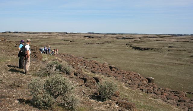
English: Drumheller Channels National Natural Landmark showcases the Drumheller Channels, which are the most significant example in the Columbia Plateau of basalt butte-and-basin channeled scablands. This National Natural Landmark is an extensively eroded landscape, located in south central Washington state characterized by hundreds of isolated, steep-sided hills (buttes) surrounded by a braided network of numerous channels, all but one of which are currently dry. It is a classic example of the tremendous erosive powers of extremely large floods such as those that reformed the Columbia Plateau volcanic terrain during the late Pleistocene glacial Missoula Floods. |
| Datum | Snímek pořízen 18. dubna 2009 |
| Zdroj | Vlastní dílo |
| Autor | Williamborg (diskuse · příspěvky) |
| Svolení (Užití tohoto souboru) |
All rights released. |
Licence[editovat]
| Já, autor tohoto díla, jej tímto uvolňuji jako volné dílo, a to celosvětově. V některých zemích to není podle zákona možné; v takovém případě: Poskytuji komukoli právo užívat toto dílo za libovolným účelem, a to bezpodmínečně s výjimkou podmínek vyžadovaných zákonem. |
Historie souboru
Kliknutím na datum a čas se zobrazí tehdejší verze souboru.
| Datum a čas | Náhled | Rozměry | Uživatel | Komentář | |
|---|---|---|---|---|---|
| současná | 19. 4. 2009, 00:47 | | 3 541 × 2 041 (1,09 MB) | Williamborg (diskuse | příspěvky) | {{Information |Description={{en|1=w:Drumheller Channels National Natural Landmark showcases the '''Drumheller Channels''', which are the most significant example in the w:Columbia Plateau of basalt butte-and-basin w:channeled scablands. This [ |
Tento soubor nemůžete přepsat.
Využití souboru
Na Commons na soubor odkazují tyto stránky:
Globální využití souboru
Tento soubor využívají následující wiki:
- Využití na ar.wikipedia.org
- Využití na cs.wikipedia.org
- Využití na de.wikipedia.org
- Využití na en.wikipedia.org
- Využití na www.wikidata.org