File:Dry line-Satellite view.jpg
Jump to navigation
Jump to search
No higher resolution available.
Dry_line-Satellite_view.jpg (481 × 348 pixels, file size: 103 KB, MIME type: image/jpeg)
Captions
Captions
Add a one-line explanation of what this file represents
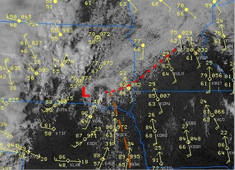
| Description | Satellite view in visible range of convection along a Dry line (yellow line) and surface station data showing temperature around 86F in the whole sector but dew points in the 60's east of it and in the 50' West of it. | |||
| Date | ||||
| Source | National Weather Service (NOAA) in a case Study of the Southeast South Dakota Tornadoes of 16 September 2006 | |||
| Author | Pierre cb | |||
| Permission (Reusing this file) |
|
File history
Click on a date/time to view the file as it appeared at that time.
| Date/Time | Thumbnail | Dimensions | User | Comment | |
|---|---|---|---|---|---|
| current | 13:30, 27 June 2016 | | 481 × 348 (103 KB) | Pierre cb (talk | contribs) | Cropped version |
| 23:52, 18 October 2007 |  | 500 × 493 (152 KB) | Pierre cb (talk | contribs) | {{Information |Description=Satellite view in visible range of convection along a Dry line (yellow line) and surface station data showing temperature around 86F in the whole sector but dew points in the 60's east of it and in the 50' West of it. |Source=[h |
You cannot overwrite this file.
File usage on Commons
There are no pages that use this file.
File usage on other wikis
The following other wikis use this file:
- Usage on fr.wikipedia.org
- Usage on ja.wikipedia.org