File:Dublin East & Ctr w Roads & Trams w Termini inc centre pt Nelsons Pillar.jpg

Original file (1,255 × 2,042 pixels, file size: 1.88 MB, MIME type: image/jpeg)
Captions
Captions
Summary
[edit]
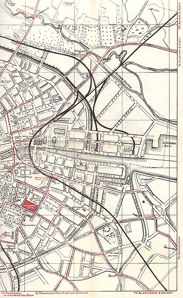
| Description | Sketch-style map of Dublin (Ireland), east and centre, N and S of R Liffey, with land use (note green areas), key buildings, rivers, roads, railways, and also tram lines, inc stops and termini, inc system central point, Nelson's Pillar, and power plant |
| Date | |
| Source | Map (perhaps E half of a set of 2?), apparently from a Guide to Dublin, dated on reverse 1912 |
| Author | Unknown (publishing house graphic) |
| Permission (Reusing this file) |
copyright expired (in Russia, 50 yrs from publication; in EU, for unknown author, 70 years from publication; in USA, all works pre-1923) |
Licensing
[edit]
|
This work is in the public domain in its country of origin and other countries and areas where the copyright term is the author's life plus 70 years or fewer.
| |
| This file has been identified as being free of known restrictions under copyright law, including all related and neighboring rights. | |
Notes
[edit]
- The exiting rail and road lines marked for "Raheny and Howth" are only ordinary road and mainline rail - unlike other exit points, there is no tram line, though one was originally planned (Nelson's Pillar-Fairview-Killester-Raheny-Howth) but abandoned in favour of the cheaper-but-longer Dublin-Clontarf-Dollymount-RahenyByTheSea-Sutton-Howth line operated by the Clontarf and Hill of Howth Trams) Car32moscow (talk) 06:47, 11 August 2008 (UTC)
- Note also the shape of the mouth of the R Tolka, the number of main rail stations in the port area and the parkland, as well as the prominence of the Shelbourn Hotel.
File history
Click on a date/time to view the file as it appeared at that time.
| Date/Time | Thumbnail | Dimensions | User | Comment | |
|---|---|---|---|---|---|
| current | 06:42, 11 August 2008 | | 1,255 × 2,042 (1.88 MB) | Car32moscow (talk | contribs) | {{Information |Description=Sketch-style map of Dublin, Ireland, east and centre, North and South of R Liffey, with roads and also tram lines, inc stops and termini, inc system central point, Nelson's Pillar, and power plant |Source=Map (perhaps E half of |
You cannot overwrite this file.
File usage on Commons
There are no pages that use this file.
File usage on other wikis
The following other wikis use this file:
- Usage on en.wikipedia.org