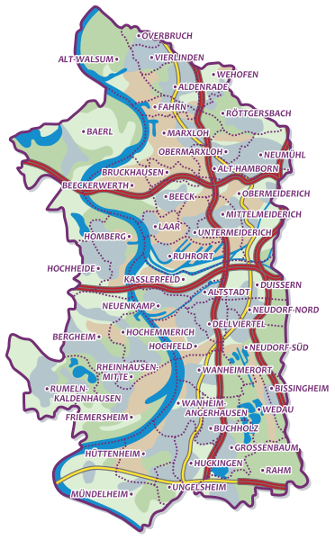
File:Duisburg Karte Allgemein.svg
From Wikimedia Commons, the free media repository
Jump to navigation
Jump to search

Size of this PNG preview of this SVG file: 372 × 599 pixels. Other resolutions: 149 × 240 pixels | 298 × 480 pixels | 477 × 768 pixels | 636 × 1,024 pixels | 1,271 × 2,048 pixels | 624 × 1,005 pixels.
Original file (SVG file, nominally 624 × 1,005 pixels, file size: 967 KB)
File information
Structured data
Captions
Captions
Add a one-line explanation of what this file represents
Deutsch: Falls sich etwas geändert haben sollte, und du die Änderungen nicht selbst vornehmen kannst, schreib mir auf meine Diskussionsseite.
English: If something has changed and you are not able to edit it yourself, leave me a message on my User talk page.
Summary[edit]
| DescriptionDuisburg Karte Allgemein.svg |
|
| Date | |
| Source |
|
| Author | Markus Baumer |
| Permission (Reusing this file) |
I, the author of this work, hereby publish it under the following license: This file is licensed under the Creative Commons Attribution-Share Alike 2.0 Germany license.
 |
File history
Click on a date/time to view the file as it appeared at that time.
| Date/Time | Thumbnail | Dimensions | User | Comment | |
|---|---|---|---|---|---|
| current | 11:34, 12 February 2010 |  | 624 × 1,005 (967 KB) | Markus1983 (talk | contribs) | Missing dot before "Ungelsheim" fixed |
| 09:31, 3 February 2010 |  | 624 × 1,005 (976 KB) | Markus1983 (talk | contribs) | map fix (rhein) | |
| 16:20, 2 February 2010 |  | 624 × 1,005 (972 KB) | Markus1983 (talk | contribs) | map fix | |
| 16:05, 2 February 2010 |  | 624 × 1,005 (973 KB) | Markus1983 (talk | contribs) | Better Positions of Labels | |
| 13:47, 2 February 2010 |  | 614 × 1,005 (983 KB) | Markus1983 (talk | contribs) | {{de|Falls sich etwas geändert haben sollte, und du die Änderungen nicht selbst vornehmen kannst, schreib mir auf meine Diskussionsseite.}} {{en|If something has changed and you are not able to edit it yourself, le |
You cannot overwrite this file.
File usage on Commons
There are no pages that use this file.
File usage on other wikis
The following other wikis use this file:
- Usage on de.wikipedia.org
Hidden category: