File:Dundas Street Route Map.jpg
Jump to navigation
Jump to search

Size of this preview: 800 × 550 pixels. Other resolutions: 320 × 220 pixels | 640 × 440 pixels | 804 × 553 pixels.
Original file (804 × 553 pixels, file size: 346 KB, MIME type: image/jpeg)
Captions
Captions
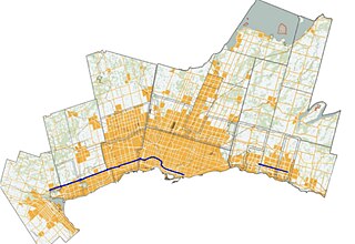
Route of Dundas Street in the Greater Toronto-Hamilton Area (GTHA), is highlighted in blue on the map.
Summary
[edit]
| Description |
English: Route of Dundas Street in the Greater Toronto-Hamilton Area (GTHA), is highlighted in blue on the map. |
| Date | |
| Source | Wikimedia Commons |
| Author | SusanRichards85 - Modification of original by Awmcphee and Transportfan70 |
Licensing
[edit]
| This file is made available under the Creative Commons CC0 1.0 Universal Public Domain Dedication. | |
| The person who associated a work with this deed has dedicated the work to the public domain by waiving all of their rights to the work worldwide under copyright law, including all related and neighboring rights, to the extent allowed by law. You can copy, modify, distribute and perform the work, even for commercial purposes, all without asking permission.
|
File history
Click on a date/time to view the file as it appeared at that time.
| Date/Time | Thumbnail | Dimensions | User | Comment | |
|---|---|---|---|---|---|
| current | 21:52, 3 August 2024 | | 804 × 553 (346 KB) | SusanRichards85 (talk | contribs) | Uploaded a work by SusanRichards85 - Modification of original by Awmcphee and Transportfan70 from Wikimedia Commons with UploadWizard |
You cannot overwrite this file.
File usage on Commons
There are no pages that use this file.