File:Durango distrito 04.png
Jump to navigation
Jump to search

Size of this preview: 565 × 600 pixels. Other resolutions: 226 × 240 pixels | 588 × 624 pixels.
Original file (588 × 624 pixels, file size: 70 KB, MIME type: image/png)
Captions
Captions
Add a one-line explanation of what this file represents
Summary[edit]
| Description |
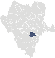
Español: Mapa del IV Distrito Electoral Federal del estado de Durango, México.
English: Map of the Fourth Federal Electoral District of the State of Durango, México. |
||
| Date | |||
| Source | Own work | ||
| Author | Battroid | ||
| Permission (Reusing this file) |
|
File history
Click on a date/time to view the file as it appeared at that time.
| Date/Time | Thumbnail | Dimensions | User | Comment | |
|---|---|---|---|---|---|
| current | 06:38, 25 August 2007 | | 588 × 624 (70 KB) | Battroid (talk | contribs) | == Summary == {{Information| |Description=*{{es icon}} Mapa del IV Distrito Electoral Federal del estado de Durango, México. *{{en icon}} Map of the Fourth Federal Electoral District of the State of Durango, México. |Source=own work |Date=August 25, 200 |
You cannot overwrite this file.
File usage on Commons
There are no pages that use this file.
File usage on other wikis
The following other wikis use this file:
- Usage on es.wikipedia.org