File:EB1 Plate XCI.png
Jump to navigation
Jump to search

Size of this preview: 791 × 600 pixels. Other resolutions: 317 × 240 pixels | 633 × 480 pixels | 1,013 × 768 pixels | 1,280 × 970 pixels | 2,560 × 1,940 pixels | 2,751 × 2,085 pixels.
Original file (2,751 × 2,085 pixels, file size: 2.6 MB, MIME type: image/png)
Captions
Captions
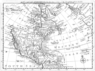
A map of North America c. 1763
Summary[edit]
| Description |
English: Plate XCI from the Encyclopaedia Britannica, 1st ed. A map of North America c. 1761 with changes added to reflect the terms of treaties ending the French and Indian Wars. For the EB1 version, Europe added to the right side of the map. |
| Date | Drawn 1761, edited 1763, edited & reengraved 1771. |
| Source | Encyclopaedia Britannica, 1st ed., Vol. II, p. 680 ff. |
| Author | Andrew Dury, cartographer, and John Spilsbury, engraver. Credited to Andrew Bell. |
| Other versions |
|

Licensing[edit]
|
This work is in the public domain in its country of origin and other countries and areas where the copyright term is the author's life plus 70 years or fewer. This work is in the public domain in the United States because it was published (or registered with the U.S. Copyright Office) before January 1, 1929. | |
| This file has been identified as being free of known restrictions under copyright law, including all related and neighboring rights. | |
File history
Click on a date/time to view the file as it appeared at that time.
| Date/Time | Thumbnail | Dimensions | User | Comment | |
|---|---|---|---|---|---|
| current | 20:15, 15 January 2023 | | 2,751 × 2,085 (2.6 MB) | LlywelynII (talk | contribs) | Uploaded a work by Andrew Bell, engraver. from ''Encyclopaedia Britannica'', 1st ed., Vol. II, [https://archive.org/details/1771EncyclopediaBritannicaNLS/First%20edition%2C%201771%20-%20Encyclopaedia%20Britannica%3B%20or%2C%20A%20dictionary%20of%20arts%20and%20sciences%2C%20compiled%20upon%20a%20new%20plan%20%E2%80%A6%2C%20Volume%202%2C%20C-L/page/n649/mode/2up p. 680 ff.] with UploadWizard |
You cannot overwrite this file.
File usage on Commons
The following page uses this file:
File usage on other wikis
The following other wikis use this file:
- Usage on en.wikisource.org