File:EFS highres STS066 STS066-101-39.JPG
ナビゲーションに移動
検索に移動

このプレビューのサイズ: 600 × 600 ピクセル。 その他の解像度: 240 × 240 ピクセル | 480 × 480 ピクセル | 768 × 768 ピクセル | 1,024 × 1,024 ピクセル | 2,048 × 2,048 ピクセル | 4,030 × 4,030 ピクセル。
元のファイル (4,030 × 4,030 ピクセル、ファイルサイズ: 14.71メガバイト、MIME タイプ: image/jpeg)
キャプション
キャプション
このファイルの内容を1行で記述してください
概要[編集]
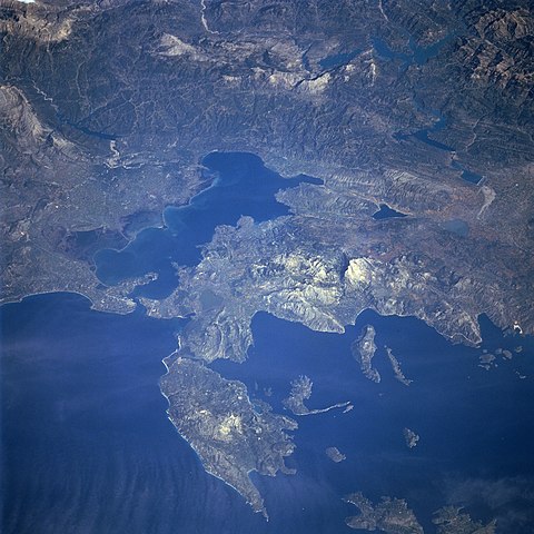
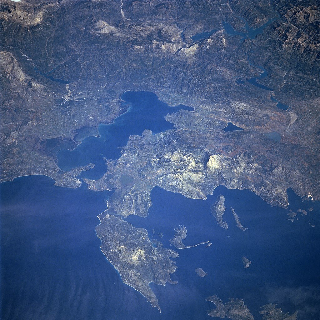
Photograph of the Ambracian Gulf, taken by space-shuttle mission STS-66 in November 1994.
Original caption, from [1] アーカイブされたコピー at the Wayback Machine:
- STS066-101-039 Levkas Island, Ambracian Bay, Greece November, 1994
- The Ambracian Bay, an inlet of the Ionian Sea (bottom left) can be seen in this northeast-looking view. The bay, sometimes referred to as a gulf, is 25 miles 40 km) long and from 4 to 10 miles (6 to 16 km) wide. On the shores of Ambracian Bay are the ruins of several cities important to ancient Greece. Levkas (Leucas) Island is visible in the lower left quadrant of the image. Levkas Island is a mountainous island that covers an area of 115 square miles (300 square km). Olive oil, wine, and tobacco are produced on the island. Covering almost a third of the top portion of the image is the western half of the Pindus Mountains. The Pindus, trending northwest to southeast are a continuation of the Dinaric Alps, but are made up of reduced limestone content compared to the range further to the north. Extending for 100 miles (160 km), the sparsely populated, rugged range is rich in timber. Lake Takhniti, a recreational lake, is discernible in the upper right portion of the image. Ithaki Island is visible near the bottom right of the image.
| このタグは、添付された著作物の著作権状況を示すものではありません。通常の著作権タグも必要です。Commons:ライセンシングもご覧ください。 他言語での翻訳:
|
ライセンス[編集]
| このファイルはアメリカ航空宇宙局(NASA)によって作成されたものです。NASAの著作権の方針では、特記事項が無い場合、NASAの資料はパブリックドメインとなります。 (詳しくはTemplate:PD-USGov、NASAの著作権の方針について(英語)又はジェット推進研究所(JPL)の画像使用に関するガイドライン(英語)をご覧ください。) |
||
 |
注意事項:
|
ファイルの履歴
過去の版のファイルを表示するには、その版の日時をクリックしてください。
| 日付と時刻 | サムネイル | 寸法 | 利用者 | コメント | |
|---|---|---|---|---|---|
| 現在の版 | 2005年8月28日 (日) 06:21 | | 4,030 × 4,030 (14.71メガバイト) | Delirium (トーク | 投稿記録) | Photograph of the Ambracian Gulf, taken by space-shuttle mission STS-66 in November 1994. Original caption, from [http://earth.jsc.nasa.gov/sseop/efs/photoinfo.pl?PHOTO=STS066-101-39]: :STS066-101-039 Levkas Island, Ambracian Bay, Greece November, 1994 T |
このファイルは上書きできません。
ファイルの使用状況
以下のページがこのファイルを使用しています:
グローバルなファイル使用状況
以下に挙げる他のウィキがこの画像を使っています:
- ar.wikipedia.org での使用状況
- be-tarask.wikipedia.org での使用状況
- bg.wikipedia.org での使用状況
- ca.wikipedia.org での使用状況
- ceb.wikipedia.org での使用状況
- da.wikipedia.org での使用状況
- de.wikipedia.org での使用状況
- el.wikipedia.org での使用状況
- en.wikipedia.org での使用状況
- es.wikipedia.org での使用状況
- eu.wikipedia.org での使用状況
- fa.wikipedia.org での使用状況
- fr.wikipedia.org での使用状況
- gl.wikipedia.org での使用状況
- he.wikipedia.org での使用状況
- hr.wikipedia.org での使用状況
- hu.wikipedia.org での使用状況
- id.wikipedia.org での使用状況
- it.wikipedia.org での使用状況
- ja.wikipedia.org での使用状況
- ko.wikipedia.org での使用状況
- la.wikipedia.org での使用状況
- nl.wikipedia.org での使用状況
- nn.wikipedia.org での使用状況
- no.wikipedia.org での使用状況
- pl.wikipedia.org での使用状況
- pl.wiktionary.org での使用状況
- ru.wikipedia.org での使用状況
- sh.wikipedia.org での使用状況
- sq.wikipedia.org での使用状況
- sv.wikipedia.org での使用状況
- tr.wikipedia.org での使用状況
- uk.wikipedia.org での使用状況
- vi.wikipedia.org での使用状況
- www.wikidata.org での使用状況