File:ESP 017119 2040 (42224202290).jpg
Jump to navigation
Jump to search

Size of this preview: 800 × 450 pixels. Other resolutions: 320 × 180 pixels | 640 × 360 pixels | 1,024 × 576 pixels | 1,280 × 720 pixels | 2,560 × 1,440 pixels | 7,680 × 4,320 pixels.
Original file (7,680 × 4,320 pixels, file size: 7.65 MB, MIME type: image/jpeg)
Captions
Captions
Add a one-line explanation of what this file represents
Summary
[edit].jpg&action=edit§ion=1)
| Description |
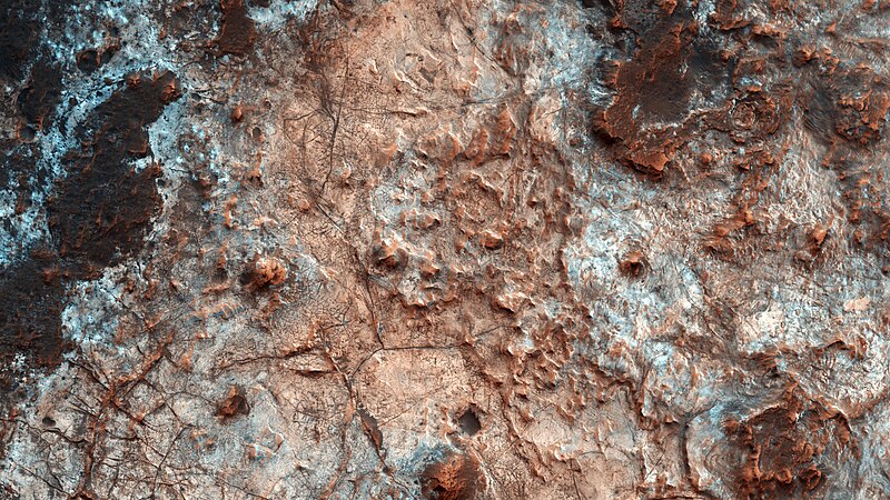
Outcrops in Mawrth Vallis — Situated between the Southern Highlands and Northern Lowlands, Mawrth Vallis is a channel formed by massive flooding which occurred in Mars’ ancient past. Additional fun fact: “Mawrth” is the Welsh word for Mars. NASA/JPL/University of Arizona (287 km above the surface, less than 1 km top to bottom and north is to the right.) Source: www.uahirise.org/ESP_017119_2040 |
| Date | |
| Source | ESP_017119_2040 |
| Author | UAHiRISE (NASA) |
Licensing
[edit].jpg&action=edit§ion=2)
| This file is in the public domain in the United States because it was solely created by NASA. NASA copyright policy states that "NASA material is not protected by copyright unless noted". (See Template:PD-USGov, NASA copyright policy page or JPL Image Use Policy.) | ||
 |
Warnings:
|
File history
Click on a date/time to view the file as it appeared at that time.
| Date/Time | Thumbnail | Dimensions | User | Comment | |
|---|---|---|---|---|---|
| current | 14:28, 16 August 2018 | | 7,680 × 4,320 (7.65 MB) | Meisam (talk | contribs) | Transferred from Flickr via #flickr2commons |
You cannot overwrite this file.
File usage on Commons
The following 2 pages use this file:
File usage on other wikis
The following other wikis use this file:
- Usage on pl.wikipedia.org
.jpg&oldid=911469738)