File:EU OCT and OMR map en.png
跳至導覽
跳至搜尋
預覽大小:800 × 492 像素。 其他解析度:320 × 197 像素 | 640 × 394 像素 | 1,024 × 630 像素 | 1,280 × 788 像素 | 2,206 × 1,358 像素。
原始檔案 (2,206 × 1,358 像素,檔案大小:1,003 KB,MIME 類型:image/png)
說明
說明
添加單行說明來描述出檔案所代表的內容
European Union territories, prior to Brexit

|
File:Special member state territories and the European Union.svg是本檔案的向量版本。 如果品質不低,就應該優先使用該檔案,而非PNG檔案。
File:EU OCT and OMR map en.png → File:Special member state territories and the European Union.svg
更多資訊請參閱Help:SVG/zh。 |
 |
摘要[編輯]
| 描述 |
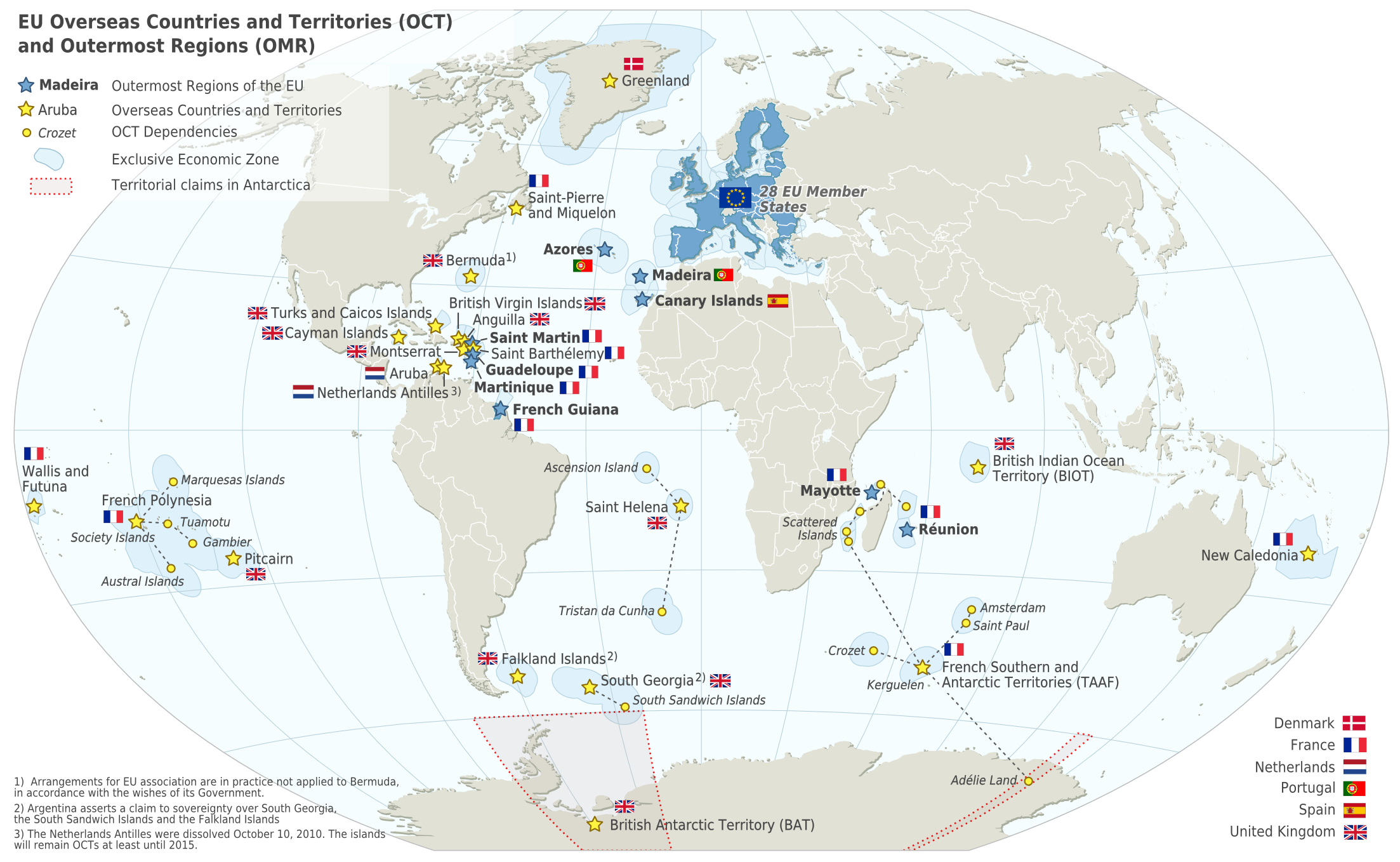
Deutsch: Karte der EU – Überseeische Länder und Hoheitsgebiete (OCT) und die Gebiete in äußerster Randlage (OMR). Diese Karte zeigt den räumlichen Geltungsbereich der Verträge der EU gemäß Artikel 52 des Vertrags über die Europäische Union und Artikel 355 des Vertrags über die Arbeitsweise der Europäischen Union.
Français : Carte de l’Union Européenne, en particulier les Pays et territoires d’outre-mer et les Régions ultrapériphériques. Cette carte montre la portée d’action territoriale des Traités de l’UE comme spécifié par l’Article 52 du Traité sur l’Union Européenne et l’Article 355 du Traité sur le Fonctionnement de l’Union Européenne.
English: Map of the EU – Overseas Countries and Territories (OCT) and Outermost Regions (OMR). This map shows the territorial scope of the Treaties of the EU as specified by Article 52 of the Treaty on European Union and Article 355 of the Treaty on the Functioning of the European Union. |
| 日期 | |
| 來源 | Natural Earth 1:50m (http://www.naturalearthdata.com) |
| 作者 | Alexrk2 |
| 其他版本 |
|
![[ar] Arabic version \ النسخة العربية](/wiki/File:Map-Europe-Outermost-regions-ar.PNG)
![[de] German version / deutsche Version](/wiki/File:Map-Europe-Outermost-regions-de.png)
![[fr] French version / version français](/wiki/File:Map-Europe-Outermost-regions-fr.png)


|
|
授權條款[編輯]
我,本作品的著作權持有者,決定用以下授權條款發佈本作品:
此檔案採用共享創意 姓名標示-相同方式分享 3.0 未在地化版本授權條款。
- 您可以自由:
- 分享 – 複製、發佈和傳播本作品
- 重新修改 – 創作演繹作品
- 惟需遵照下列條件:
- 姓名標示 – 您必須指名出正確的製作者,和提供授權條款的連結,以及表示是否有對內容上做出變更。您可以用任何合理的方式來行動,但不得以任何方式表明授權條款是對您許可或是由您所使用。
- 相同方式分享 – 如果您利用本素材進行再混合、轉換或創作,您必須基於如同原先的相同或兼容的條款,來分布您的貢獻成品。
檔案歷史
點選日期/時間以檢視該時間的檔案版本。
| 日期/時間 | 縮圖 | 尺寸 | 用戶 | 備註 | |
|---|---|---|---|---|---|
| 目前 | 2024年2月18日 (日) 06:14 | | 2,206 × 1,358(1,003 KB) | Sqrt of 2(對話 | 貢獻) | Reverted to version as of 18:05, 12 June 2023 (UTC) |
| 2024年1月15日 (一) 16:08 |  | 2,206 × 1,358(954 KB) | Multituberculata(對話 | 貢獻) | Reverted to version as of 08:53, 31 May 2023 (UTC) | |
| 2023年6月12日 (一) 18:05 |  | 2,206 × 1,358(1,003 KB) | DecafPotato(對話 | 貢獻) | Reverted to version as of 14:48, 27 February 2019 (UTC) – The image includes UK territories, and was made prior to Brexit; please keep the UK in the map as part of the European Union for this reason | |
| 2023年5月31日 (三) 08:53 |  | 2,206 × 1,358(954 KB) | Iktsokh(對話 | 貢獻) | Note | |
| 2023年5月21日 (日) 20:01 |  | 2,206 × 1,358(951 KB) | Iktsokh(對話 | 貢獻) | Correction | |
| 2023年5月18日 (四) 09:56 |  | 2,206 × 1,358(950 KB) | Iktsokh(對話 | 貢獻) | Updated | |
| 2019年2月27日 (三) 14:48 |  | 2,206 × 1,358(1,003 KB) | Radom1967(對話 | 貢獻) | Reverted to version as of 17:02, 22 March 2018 (UTC). No need | |
| 2019年2月25日 (一) 12:13 |  | 2,206 × 1,358(999 KB) | Odemirense(對話 | 貢獻) | Countries with overseas regions in dark blue | |
| 2018年3月22日 (四) 17:02 |  | 2,206 × 1,358(1,003 KB) | Maphobbyist(對話 | 貢獻) | South Sudan border | |
| 2014年1月1日 (三) 18:24 |  | 2,206 × 1,358(1 MB) | Alexrk2(對話 | 貢獻) | From 1 January 2014, the status of Mayotte will be that of an outermost region (COUNCIL DIRECTIVE 2013/61/EU of 17 December 2013) |
無法覆蓋此檔案。
檔案用途
下列4個頁面有用到此檔案:
全域檔案使用狀況
以下其他 wiki 使用了這個檔案:
- an.wikipedia.org 的使用狀況
- ar.wikipedia.org 的使用狀況
- ast.wikipedia.org 的使用狀況
- azb.wikipedia.org 的使用狀況
- bn.wikipedia.org 的使用狀況
- ca.wikipedia.org 的使用狀況
- cs.wikipedia.org 的使用狀況
- en.wikipedia.org 的使用狀況
- Aruba
- Canary Islands
- Greenland
- Guadeloupe
- Martinique
- Mayotte
- Madeira
- Netherlands Antilles
- Réunion
- Overseas departments and regions of France
- Decolonisation of Africa
- History of colonialism
- Sint Maarten
- French Guiana
- User:Kazkaskazkasako/Books/All
- Caribbean Netherlands
- User:Tom29739/The EU
- User:Abyssal/bla
- User:Falcaorib
- List of colonies
- en.wikiquote.org 的使用狀況
- en.wikivoyage.org 的使用狀況
- es.wikipedia.org 的使用狀況
- fa.wikipedia.org 的使用狀況
- fi.wikipedia.org 的使用狀況
- gl.wikipedia.org 的使用狀況
- id.wikipedia.org 的使用狀況
- ilo.wikipedia.org 的使用狀況
- it.wikipedia.org 的使用狀況
- ka.wikipedia.org 的使用狀況
- mk.wikipedia.org 的使用狀況
- nds-nl.wikipedia.org 的使用狀況
檢視此檔案的更多全域使用狀況。