File:Earth from Space- The Mekong Delta ESA268.jpg

Original file (3,787 × 5,049 pixels, file size: 26.83 MB, MIME type: image/jpeg)
Captions
Captions
Summary
[edit]| Description |
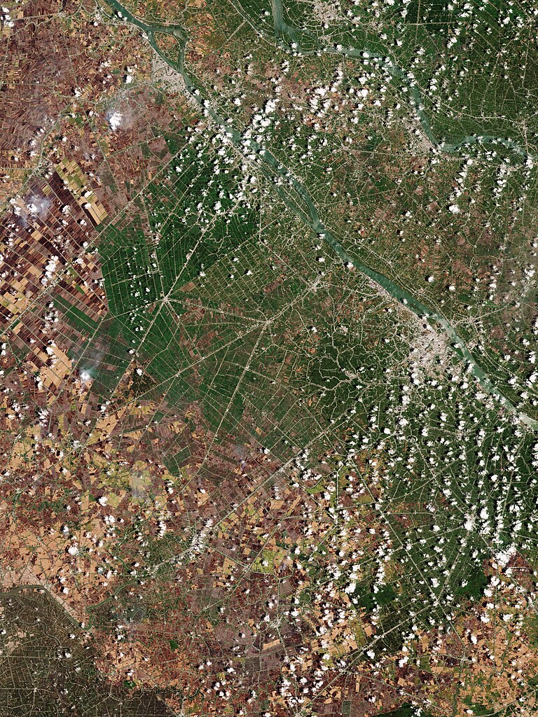
English: The Copernicus Sentinel-2 mission captured a rare, almost cloud-free image over the Mekong Delta and the city of Can Tho in southwest Vietnam. Zoom in to explore this image at its full 10 m resolution or click on the circles to learn more. The Mekong Delta is a vast flood plain formed by the longest river in southeast Asia, the Mekong, which can be seen in the top right corner of the image. Its exceptionally fertile soil has established the area as one of the world’s richest agricultural regions. The extensive patchwork of rice paddy fields can be seen across the image, intersected by an intricate web of irrigation and drainage canals. Vietnam is one of the world’s top rice producers and this region is often labelled Vietnam’s ‘rice bowl’. Different colours in the fields could signify either different stages in plant growth or different agriculture methods being used for the crops. The various colours could also be the result of a common agricultural practice in the area: post-harvest, many fields are burned to clear and prepare for the next planting cycle. Recently burned fields appear black, while those where some time has passed since burning appear in shades of brown. Notably, wisps of smoke can be spotted, particularly in the left of the image, over some plots that were being burned at the time the image was captured. There are very few roads in this area – the network of canals and waterways are used to transport people and products. All villages and cities in the area are therefore built along waterways. The large river in the image, south of the Mekong, is the Hau River, a major branch of the lower Mekong River. On its left bank lies Can Tho, the largest city of the delta region and visible as a large grey area. A large inland port, Can Tho is renowned for floating markets and for picturesque rural canals. Zooming in northwest of the city reveals the clear outline of the Can Tho International Airport. |
| Date | 19 April 2024 (upload date) |
| Source | Earth from Space: The Mekong Delta |
| Author | European Space Agency |
| Other versions |
|
| Activity | Observing the Earth |
| Mission | Sentinel-2 |
| Set | Earth from Space image collection |
| System | Copernicus |

Licensing
[edit]

|
This image contains data from a satellite in the Copernicus Programme, such as Sentinel-1, Sentinel-2 or Sentinel-3. Attribution is required when using this image.
Attribution: Contains modified Copernicus Sentinel data 2023
The use of Copernicus Sentinel Data is regulated under EU law (Commission Delegated Regulation (EU) No 1159/2013 and Regulation (EU) No 377/2014). Relevant excerpts:
Free access shall be given to GMES dedicated data [...] made available through GMES dissemination platforms [...].
Access to GMES dedicated data [...] shall be given for the purpose of the following use in so far as it is lawful:
GMES dedicated data [...] may be used worldwide without limitations in time.
GMES dedicated data and GMES service information are provided to users without any express or implied warranty, including as regards quality and suitability for any purpose. |
This media was created by the European Space Agency (ESA).
Where expressly so stated, images or videos are covered by the Creative Commons Attribution-ShareAlike 3.0 IGO (CC BY-SA 3.0 IGO) licence, ESA being an Intergovernmental Organisation (IGO), as defined by the CC BY-SA 3.0 IGO licence. The user is allowed under the terms and conditions of the CC BY-SA 3.0 IGO license to Reproduce, Distribute and Publicly Perform the ESA images and videos released under CC BY-SA 3.0 IGO licence and the Adaptations thereof, without further explicit permission being necessary, for as long as the user complies with the conditions and restrictions set forth in the CC BY-SA 3.0 IGO licence, these including that:
See the ESA Creative Commons copyright notice for complete information, and this article for additional details.
|
 | |
This file is licensed under the Creative Commons Attribution-ShareAlike 3.0 IGO license. Attribution: ESA, CC BY-SA IGO 3.0
| ||
File history
Click on a date/time to view the file as it appeared at that time.
| Date/Time | Thumbnail | Dimensions | User | Comment | |
|---|---|---|---|---|---|
| current | 06:05, 20 April 2024 | | 3,787 × 5,049 (26.83 MB) | OptimusPrimeBot (talk | contribs) | #Spacemedia - Upload of https://www.esa.int/var/esa/storage/images/esa_multimedia/images/2024/04/earth_from_space_the_mekong_delta/26037486-1-eng-GB/Earth_from_Space_The_Mekong_Delta.jpg via Commons:Spacemedia |
You cannot overwrite this file.
File usage on Commons
The following page uses this file: