File:El Toro Y.png
Jump to navigation
Jump to search
No higher resolution available.
El_Toro_Y.png (525 × 335 pixels, file size: 21 KB, MIME type: image/png)
Captions
Captions
Add a one-line explanation of what this file represents
Summary
[edit]

|
This file was moved to Wikimedia Commons from en.wikipedia using a bot script. All source information is still present. It requires review. Additionally, there may be errors in any or all of the information fields; information on this file should not be considered reliable and the file should not be used until it has been reviewed and any needed corrections have been made. Once the review has been completed, this template should be removed. For details about this file, see below. Check now! |
| Description |
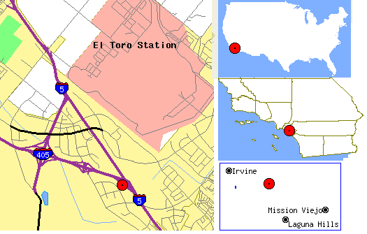
English: Map showing location of the El Toro "Y", the intersection of I-5 and I-405 near Irvine. |
| Date | 21 September 2005 (original upload date) |
| Source | Collected from U.S. Census Tiger Map Server. |
| Author | U.S. Government with contributions by me. |
Licensing
[edit]
| This work has been released into the public domain by its author, Rfc1394 at English Wikipedia. This applies worldwide. In some countries this may not be legally possible; if so: Rfc1394 grants anyone the right to use this work for any purpose, without any conditions, unless such conditions are required by law. |
Original upload log
[edit]
Transferred from en.wikipedia to Commons by Sfan00_IMG using CommonsHelper.
The original description page was here. All following user names refer to en.wikipedia.
- 2005-09-21 07:13 Rfc1394 525×335× (22007 bytes) Map showing location of the El Toro "Y", the intersection of I-5 and I-405 near [[Irvine, Califorinia]]. Collected from U.S. Census Tiger Map Server. {{Pd-user|Rfc1394}}
File history
Click on a date/time to view the file as it appeared at that time.
| Date/Time | Thumbnail | Dimensions | User | Comment | |
|---|---|---|---|---|---|
| current | 00:56, 24 July 2013 | | 525 × 335 (21 KB) | File Upload Bot (Magnus Manske) (talk | contribs) | Transfered from en.wikipedia by User:Sfan00_IMG using CommonsHelper |
You cannot overwrite this file.
File usage on Commons
There are no pages that use this file.