File:ElectoralCollege2000-Large.png
Ir a la navegación
Ir a la búsqueda
Tamaño de esta previsualización: 800 × 430 píxeles. Otras resoluciones: 320 × 172 píxeles | 640 × 344 píxeles | 1182 × 635 píxeles.
Archivo original (1182 × 635 píxeles; tamaño de archivo: 175 kB; tipo MIME: image/png)
Leyendas
Leyendas
Añade una explicación corta acerca de lo que representa este archivo
| U.S. presidential election maps from the National Atlas of the United States |
| See also: SVG maps |
| 1789 · 1792 · 1796 · 1800 · 1804 · 1808 · 1812 · 1816 · 1820 · 1824 · 1828 · 1832 · 1836 · 1840 · 1844 · 1848 · 1852 · 1856 · 1860 · 1864 · 1868 · 1872 · 1876 · 1880 · 1884 · 1888 · 1892 · 1896 · 1900 · 1904 · 1908 · 1912 · 1916 · 1920 · 1924 · 1928 · 1932 · 1936 · 1940 · 1944 · 1948 · 1952 · 1956 · 1960 · 1964 · 1968 · 1972 · 1976 · 1980 · 1984 · 1988 · 1992 · 1996 · 2000 · 2004 |
Resumen[editar]
| Descripción |
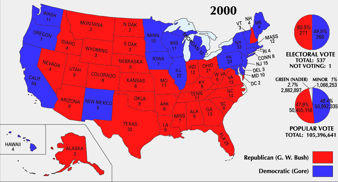
English: 2000 Electoral College Map |
|||
| Fuente | https://nationalmap.gov/small_scale/printable/elections.html | |||
| Autor | Servicio Geológico de los Estados Unidos | |||
| Otras versiones |
|


Licencia[editar]
This map was obtained from an edition of the National Atlas of the United States. Like almost all works of the U.S. federal government, works from the National Atlas are in the public domain in the United States.
Online access: NationalAtlas.gov | 1970 print edition: Library of Congress, Perry-Castañeda Library
|
Historial del archivo
Haz clic sobre una fecha y hora para ver el archivo tal como apareció en ese momento.
| Fecha y hora | Miniatura | Dimensiones | Usuario | Comentario | |
|---|---|---|---|---|---|
| actual | 23:51 25 jun 2008 | | 1182 × 635 (175 kB) | Tallicfan20 (discusión | contribs.) | better resolution |
| 01:02 14 feb 2008 |  | 1182 × 635 (83 kB) | SteveSims~commonswiki (discusión | contribs.) | Reverted to version as of 10:23, 25 July 2007. The version with Nader as green didn't look very good. | |
| 22:08 7 feb 2008 |  | 1182 × 635 (2,15 MB) | SteveSims~commonswiki (discusión | contribs.) | Ralph Nader's popular votes made green. Also public domain. | |
| 10:23 25 jul 2007 |  | 1182 × 635 (83 kB) | Cardsplayer4life~commonswiki (discusión | contribs.) | Reverted to earlier revision | |
| 09:46 25 jul 2007 |  | 1182 × 635 (62 kB) | Joseph Solis in Australia~commonswiki (discusión | contribs.) | {{PD-USGov-Atlas}} Category:2000 {{US presidential election maps}} | |
| 02:30 2 jul 2007 |  | 1182 × 635 (83 kB) | Cardsplayer4life~commonswiki (discusión | contribs.) | {{PD-USGov-Atlas}} Source: EN Wiki {{US presidential election maps}} | |
| 10:08 29 jun 2007 |  | 1182 × 635 (62 kB) | Joseph Solis in Australia~commonswiki (discusión | contribs.) | {{PD-USGov-Atlas}} Category:2000 {{US presidential election maps}} | |
| 21:04 21 jun 2007 |  | 1182 × 635 (83 kB) | Cardsplayer4life~commonswiki (discusión | contribs.) | {{PD-USGov-Atlas}} Category:2000 {{US presidential election maps}} | |
| 10:21 19 ago 2005 |  | 1182 × 635 (62 kB) | Ondrejk (discusión | contribs.) | {{PD-USGov-Atlas}} Source: EN Wiki |
No puedes sobrescribir este archivo.
Usos del archivo
Las siguientes páginas usan este archivo:
Uso global del archivo
Las wikis siguientes utilizan este archivo:
- Uso en el.wikipedia.org
- Uso en en.wikipedia.org
- Uso en fa.wikipedia.org
- Uso en sv.wikipedia.org
- Uso en uk.wikipedia.org