File:ElectoralCollege2000-Large.png
跳转到导航
跳转到搜索
本预览的尺寸:800 × 430像素。 其他分辨率:320 × 172像素 | 640 × 344像素 | 1,182 × 635像素。
原始文件 (1,182 × 635像素,文件大小:175 KB,MIME类型:image/png)
说明
说明
添加一行文字以描述该文件所表现的内容
| U.S. presidential election maps from the National Atlas of the United States |
| See also: SVG maps |
| 1789 · 1792 · 1796 · 1800 · 1804 · 1808 · 1812 · 1816 · 1820 · 1824 · 1828 · 1832 · 1836 · 1840 · 1844 · 1848 · 1852 · 1856 · 1860 · 1864 · 1868 · 1872 · 1876 · 1880 · 1884 · 1888 · 1892 · 1896 · 1900 · 1904 · 1908 · 1912 · 1916 · 1920 · 1924 · 1928 · 1932 · 1936 · 1940 · 1944 · 1948 · 1952 · 1956 · 1960 · 1964 · 1968 · 1972 · 1976 · 1980 · 1984 · 1988 · 1992 · 1996 · 2000 · 2004 |
摘要
[编辑]| 描述 |
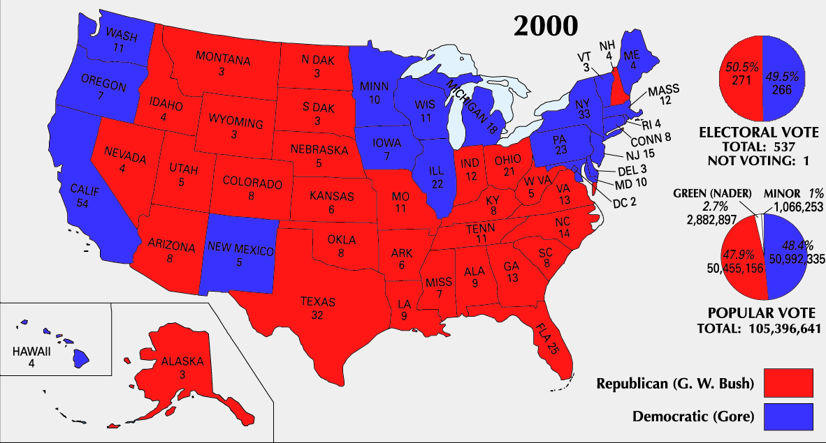
English: 2000 Electoral College Map |
|||
| 来源 | https://nationalmap.gov/small_scale/printable/elections.html | |||
| 作者 | 美国地质调查局 | |||
| 其他版本 |
|


许可协议
[编辑]
本地图取自美国国家地图集的某个版本。正如几乎所有美国联邦政府作品一样,来自国家地图集的作品在美国属于公有领域。
在线访问:NationalAtlas.gov | 1970年印刷版:国会图书馆、Perry-Castañeda图书馆
|
文件历史
点击某个日期/时间查看对应时刻的文件。
| 日期/时间 | 缩略图 | 大小 | 用户 | 备注 | |
|---|---|---|---|---|---|
| 当前 | 2008年6月25日 (三) 23:51 | | 1,182 × 635(175 KB) | Tallicfan20(留言 | 贡献) | better resolution |
| 2008年2月14日 (四) 01:02 |  | 1,182 × 635(83 KB) | SteveSims~commonswiki(留言 | 贡献) | Reverted to version as of 10:23, 25 July 2007. The version with Nader as green didn't look very good. | |
| 2008年2月7日 (四) 22:08 |  | 1,182 × 635(2.15 MB) | SteveSims~commonswiki(留言 | 贡献) | Ralph Nader's popular votes made green. Also public domain. | |
| 2007年7月25日 (三) 10:23 |  | 1,182 × 635(83 KB) | Cardsplayer4life~commonswiki(留言 | 贡献) | Reverted to earlier revision | |
| 2007年7月25日 (三) 09:46 |  | 1,182 × 635(62 KB) | Joseph Solis in Australia~commonswiki(留言 | 贡献) | {{PD-USGov-Atlas}} Category:2000 {{US presidential election maps}} | |
| 2007年7月2日 (一) 02:30 |  | 1,182 × 635(83 KB) | Cardsplayer4life~commonswiki(留言 | 贡献) | {{PD-USGov-Atlas}} Source: EN Wiki {{US presidential election maps}} | |
| 2007年6月29日 (五) 10:08 |  | 1,182 × 635(62 KB) | Joseph Solis in Australia~commonswiki(留言 | 贡献) | {{PD-USGov-Atlas}} Category:2000 {{US presidential election maps}} | |
| 2007年6月21日 (四) 21:04 |  | 1,182 × 635(83 KB) | Cardsplayer4life~commonswiki(留言 | 贡献) | {{PD-USGov-Atlas}} Category:2000 {{US presidential election maps}} | |
| 2005年8月19日 (五) 10:21 |  | 1,182 × 635(62 KB) | Ondrejk(留言 | 贡献) | {{PD-USGov-Atlas}} Source: EN Wiki |
您不可以覆盖此文件。
文件用途
以下3个页面使用本文件:
全域文件用途
以下其他wiki使用此文件:
- el.wikipedia.org上的用途
- en.wikipedia.org上的用途
- fa.wikipedia.org上的用途
- sv.wikipedia.org上的用途
- uk.wikipedia.org上的用途