File:Electric power distribution sector in Japan.svg
Jump to navigation
Jump to search

Size of this PNG preview of this SVG file: 800 × 533 pixels. Other resolutions: 320 × 213 pixels | 640 × 427 pixels | 1,024 × 683 pixels | 1,280 × 853 pixels | 2,560 × 1,707 pixels.
Original file (SVG file, nominally 900 × 600 pixels, file size: 186 KB)
Captions
Captions
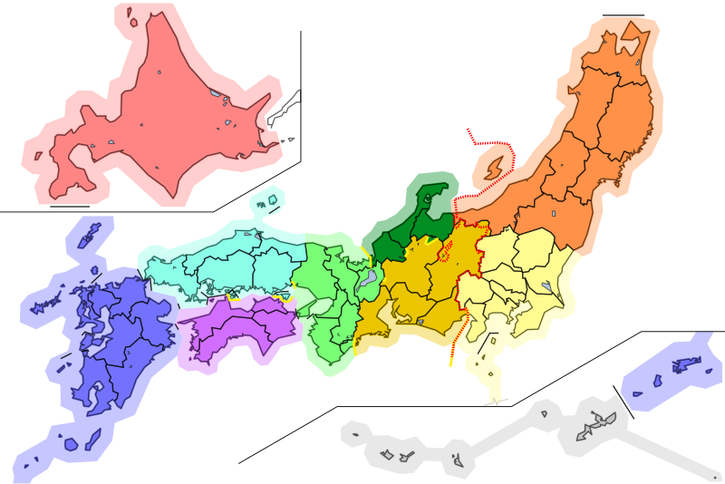
Map of Electric power distribution sector in Japan
Summary[edit]
| Description |
日本語: 日本の電力の一般送配電事業者(電力会社)の管轄区域を示した地図、都道府県境、電源周波数境界(50 または 60 Hz)つき。
管轄境界(※都道府県境界と異なる部分のみ) 電源周波数境界 画像左側(西日本)60Hz / 右側(東日本)および長野県の一部飛地(松本市西部など)50Hz 都道府県境界 海岸線 English: Map of jurisdiction of electric power transmission and distribution companies in Japan, with prefecture boundary, electric power frequency boundary(50 or 60 Hz).
boundary of company jurisdiction (only area distinct from boundary of prefecture) boundary of electric power frequency: left of line (west Japan) 60Hz / right of line(east Japan) and enclave in Nagano pref.(western Matsumoto City Area, etc,) 50Hz boundary of prefecture coastline |
| Date | |
| Source | Map based on File:Japan Map Lincun.svg |
| Author | Peka / a base map by Lincun |
Licensing[edit]
This file is licensed under the Creative Commons Attribution-Share Alike 3.0 Unported license.
- You are free:
- to share – to copy, distribute and transmit the work
- to remix – to adapt the work
- Under the following conditions:
- attribution – You must give appropriate credit, provide a link to the license, and indicate if changes were made. You may do so in any reasonable manner, but not in any way that suggests the licensor endorses you or your use.
- share alike – If you remix, transform, or build upon the material, you must distribute your contributions under the same or compatible license as the original.
File history
Click on a date/time to view the file as it appeared at that time.
| Date/Time | Thumbnail | Dimensions | User | Comment | |
|---|---|---|---|---|---|
| current | 14:40, 2 December 2021 | | 900 × 600 (186 KB) | Peka (talk | contribs) | append in Gifu pref. / 岐阜県郡上市石徹白を追加 |
| 12:30, 2 December 2021 |  | 900 × 600 (185 KB) | Peka (talk | contribs) | Uploaded a work by Peka / a base map by Lincun from Map based on File:Japan Map Lincun.svg with UploadWizard |
You cannot overwrite this file.
File usage on Commons
The following 5 pages use this file:
File usage on other wikis
The following other wikis use this file:
- Usage on de.wikipedia.org
- Usage on ja.wikipedia.org
- Usage on www.wikidata.org