File:Elizabeth Lake with Sunburst Valley.jpg
From Wikimedia Commons, the free media repository
Jump to navigation
Jump to search
![File:Elizabeth Lake with Sunburst Valley.jpg](https://upload.wikimedia.org/wikipedia/commons/thumb/f/ff/Elizabeth_Lake_with_Sunburst_Valley.jpg/800px-Elizabeth_Lake_with_Sunburst_Valley.jpg?20090524054414)
Size of this preview: 800 × 533 pixels. Other resolutions: 320 × 213 pixels | 640 × 427 pixels | 1,024 × 683 pixels | 1,280 × 853 pixels | 2,560 × 1,707 pixels | 4,224 × 2,816 pixels.
Original file (4,224 × 2,816 pixels, file size: 2.88 MB, MIME type: image/jpeg)
File information
Structured data
Captions
Captions
Add a one-line explanation of what this file represents
Summary
[edit]DescriptionElizabeth Lake with Sunburst Valley.jpg |
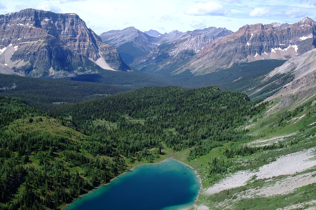
English: Elizabeth Lake with Sunburst Valley, seen from "The Nublet". The mountain on the left side is Mount Watson, in front of it Wedgwood Lake can be seen. Mitchell River Valley leads to the Kootenay. |
Date | |
Source | Own work |
Author | Kurt Stegmüller |
Camera location | 50° 55′ 15″ N, 115° 38′ 56″ W ![]() | View this and other nearby images on: OpenStreetMap | ![]() |
---|
Licensing
[edit]I, the copyright holder of this work, hereby publish it under the following licenses:
![w:en:Creative Commons](https://upload.wikimedia.org/wikipedia/commons/thumb/7/79/CC_some_rights_reserved.svg/90px-CC_some_rights_reserved.svg.png)
![attribution](https://upload.wikimedia.org/wikipedia/commons/thumb/1/11/Cc-by_new_white.svg/24px-Cc-by_new_white.svg.png)
![share alike](https://upload.wikimedia.org/wikipedia/commons/thumb/d/df/Cc-sa_white.svg/24px-Cc-sa_white.svg.png)
This file is licensed under the Creative Commons Attribution-Share Alike 3.0 Unported license.
- You are free:
- to share – to copy, distribute and transmit the work
- to remix – to adapt the work
- Under the following conditions:
- attribution – You must give appropriate credit, provide a link to the license, and indicate if changes were made. You may do so in any reasonable manner, but not in any way that suggests the licensor endorses you or your use.
- share alike – If you remix, transform, or build upon the material, you must distribute your contributions under the same or compatible license as the original.
![]() |
Permission is granted to copy, distribute and/or modify this document under the terms of the GNU Free Documentation License, Version 1.2 or any later version published by the Free Software Foundation; with no Invariant Sections, no Front-Cover Texts, and no Back-Cover Texts. A copy of the license is included in the section entitled GNU Free Documentation License.http://www.gnu.org/copyleft/fdl.htmlGFDLGNU Free Documentation Licensetruetrue |
You may select the license of your choice.
Annotations InfoField | This image is annotated: View the annotations at Commons |
32
85
1378
840
4224
2816
Mount Watson
3110
137
1109
692
4224
2816
Indian Peak
1632
317
253
217
4224
2816
Mount Sam
2698
338
296
116
4224
2816
Octopus Mountain
1980
380
127
95
4224
2816
Mt. Selkirk
File history
Click on a date/time to view the file as it appeared at that time.
Date/Time | Thumbnail | Dimensions | User | Comment | |
---|---|---|---|---|---|
current | 05:44, 24 May 2009 | ![]() | 4,224 × 2,816 (2.88 MB) | KurtSteg (talk | contribs) | {{Information |Description={{en|1=Elizabeth Lake with Sunburst Valley, seen from "The Nublet". The mountain on the left side is Mount Watson, in front of it Wedgwood Lake can be seen. Mitchell River Valley leads to the Kootenay.}} |Source=Own work by uplo |
You cannot overwrite this file.
File usage on Commons
The following page uses this file:
File usage on other wikis
The following other wikis use this file:
- Usage on ceb.wikipedia.org
- Usage on de.wikipedia.org
- Usage on en.wikipedia.org
- Usage on hr.wikipedia.org
- Usage on www.wikidata.org
Metadata
This file contains additional information such as Exif metadata which may have been added by the digital camera, scanner, or software program used to create or digitize it. If the file has been modified from its original state, some details such as the timestamp may not fully reflect those of the original file. The timestamp is only as accurate as the clock in the camera, and it may be completely wrong.
Image title |
|
---|---|
Camera manufacturer | FUJIFILM |
Camera model | FinePix F100fd |
Exposure time | 1/850 sec (0.0011764705882353) |
F-number | f/3.5 |
ISO speed rating | 100 |
Date and time of data generation | 12:12, 31 July 2008 |
Lens focal length | 8.1 mm |
Latitude | 50° 55′ 15″ N |
Longitude | 115° 38′ 56″ W |
Altitude | 0 meters above sea level |
Orientation | Normal |
Horizontal resolution | 72 dpi |
Vertical resolution | 72 dpi |
Software used | Picasa 3.0 |
File change date and time | 11:08, 29 December 2008 |
Y and C positioning | Co-sited |
Exposure Program | Normal program |
Exif version | 2.2 |
Date and time of digitizing | 12:12, 31 July 2008 |
Meaning of each component |
|
Image compression mode | 2 |
APEX shutter speed | 9.79 |
APEX aperture | 3.6 |
APEX brightness | 8.01 |
APEX exposure bias | 0 |
Maximum land aperture | 3.4 APEX (f/3.25) |
Metering mode | Pattern |
Light source | Unknown |
Flash | Flash did not fire, compulsory flash suppression |
Supported Flashpix version | 1 |
Color space | sRGB |
Focal plane X resolution | 5,298 |
Focal plane Y resolution | 5,298 |
Focal plane resolution unit | 3 |
Sensing method | One-chip color area sensor |
File source | Digital still camera |
Scene type | A directly photographed image |
Custom image processing | Custom process |
Exposure mode | Auto exposure |
White balance | Auto white balance |
Scene capture type | Standard |
Sharpness | Normal |
Subject distance range | Unknown |
Unique image ID | f53348d182e5a34c348a895ed473028f |
GPS tag version | 2.2.0.0 |
Supported Flashpix version | 0 |
Image width | 4,224 px |
Image height | 2,816 px |
Date metadata was last modified | 12:08, 29 December 2008 |
Keywords |
|