File:Emb Krishna.jpg
Aller à la navigation
Aller à la recherche
Taille de cet aperçu : 593 × 600 pixels. Autres résolutions : 237 × 240 pixels | 633 × 640 pixels.
Fichier d’origine (633 × 640 pixels, taille du fichier : 100 kio, type MIME : image/jpeg)
Légendes
Légendes
Ajoutez en une ligne la description de ce que représente ce fichier
Description
[modifier]
| Description |
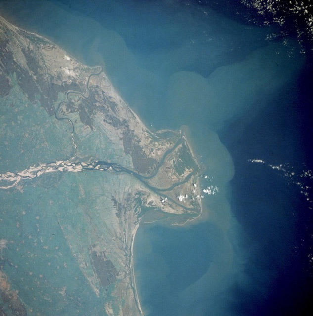
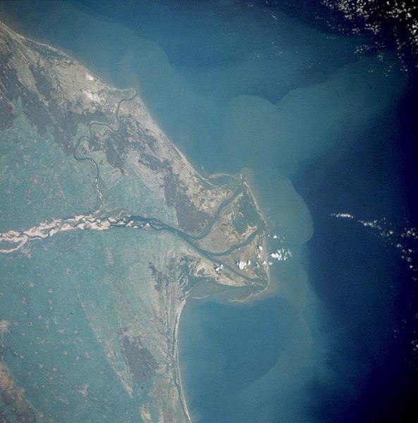
Français : le delta de la fr:Krishna.
English: Krishna River, India
The Krishna River flows eastward across the Deccan Plateau of southern India until it empties through four major distributaries into the Bay of Bengal. The river, with its headwaters in the eastern slopes of the Western Ghats, flows eastward for approximately 800 miles (1300 kilometers) until it bends southward for the last 50 miles (80 kilometers). The Krishna River delta is typical of the wider deltas along the southeast coast of India (also known as the Coromandel Coast). The braided stream channels, broad floodplain, and extensive sandbars suggest that this part of the Krishna River flows through relatively flat terrain and carries substantial amounts of sediment, especially during the monsoon season. The outline of the city of Guntur and nearby, smaller rice-producing towns are visible near the northwest edge of the photograph. |
| Date | |
| Source |
http://earth.jsc.nasa.gov/sseop/EFS/photoinfo.pl?PHOTO=STS032-72-61
|
| Auteur | Earth Sciences and Image Analysis, NASA-Johnson Space Center |
Cette image ou vidéo a été cataloguée par l’un des centres de la National Aeronautics and Space Administration (NASA) des États-Unis sous Photo ID : STS032-72-61.Ce bandeau n’indique rien sur le statut de l’œuvre au regard du droit d'auteur. Un bandeau de droit d’auteur est requis. Voir Commons:À propos des licences pour plus d’informations. Autres langues :
|
Conditions d’utilisation
[modifier]
| Ce fichier provient de la NASA. Sauf exception, les documents créés par la NASA ne sont pas soumis à copyright. Pour plus d'informations, voir la politique de copyright de la NASA. | ||
 |
Attention :
|
Journal des téléversements d’origine
[modifier]
La page de description originale était ici. Tous les noms d'utilisateur qui suivent se rapportent à fr.wikipedia.
- 2004-09-05 21:02 Nataraja 633×640× (102370 bytes) le delta de la Krishnâ
Historique du fichier
Cliquer sur une date et heure pour voir le fichier tel qu'il était à ce moment-là.
| Date et heure | Vignette | Dimensions | Utilisateur | Commentaire | |
|---|---|---|---|---|---|
| actuel | 21 octobre 2008 à 23:07 | | 633 × 640 (100 kio) | File Upload Bot (Magnus Manske) (d | contributions) | {{BotMoveToCommons|fr.wikipedia}} {{Information |Description={{fr|le delta de la fr:Krishnâ STS032-72-61 Krishna River, India The Krishna River flows eastward across the Deccan Plateau of southern India until it empties through four major distri |
Vous ne pouvez pas remplacer ce fichier.
Utilisations locales du fichier
La page suivante utilise ce fichier :
Utilisations du fichier sur d’autres wikis
Les autres wikis suivants utilisent ce fichier :
- Utilisation sur ca.wikipedia.org
- Utilisation sur es.wikipedia.org
- Utilisation sur hy.wikipedia.org
- Utilisation sur it.wikipedia.org
- Utilisation sur mr.wikipedia.org
- Utilisation sur nn.wikipedia.org