File:Empire of the Kökturks.png
跳至導覽
跳至搜尋

預覽大小:800 × 499 像素。 其他解析度:320 × 200 像素 | 640 × 399 像素 | 1,024 × 638 像素 | 1,280 × 798 像素 | 1,745 × 1,088 像素。
原始檔案 (1,745 × 1,088 像素,檔案大小:2.56 MB,MIME 類型:image/png)
說明
說明
添加單行說明來描述出檔案所代表的內容
摘要
[編輯]
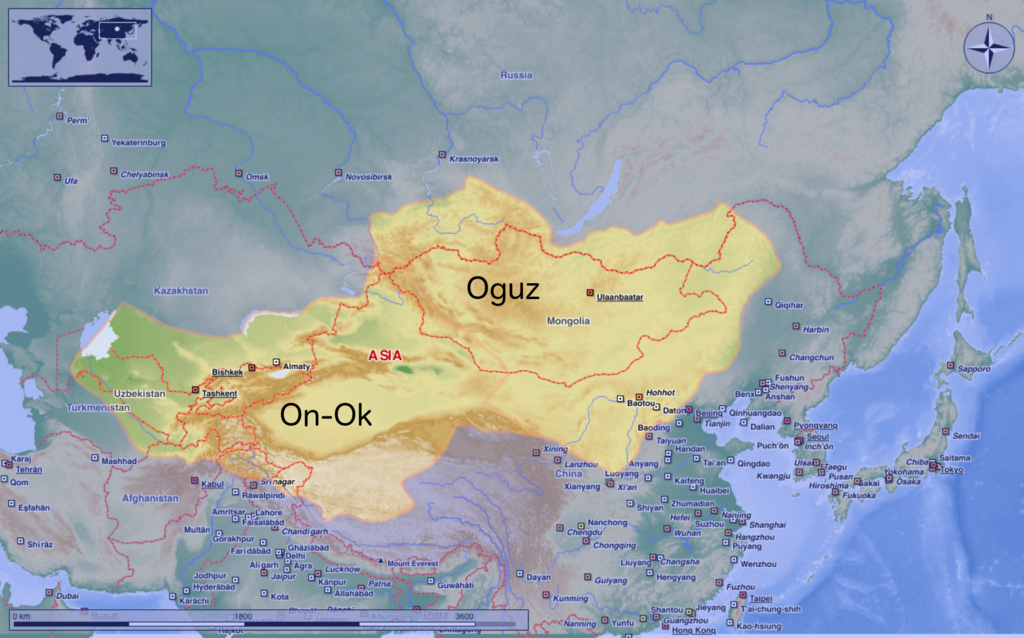
| 描述 | This map shows the kingdom of Kökturks after the division of the kingdom in 552. The grey area shows the area of On-Ok or the western Kökturks. The white area shows the area of the eastern Kökturk. This area was still in the sixth Century a Chinese protectorate. 745 the Kökturks were part of the Uyghur empire. After 840 Kökturks and the Uyghurs were conquered by the Kyrgyz. The source of this map: "Der große Atlas Weltgeschichte", Orbis Verlag 1990, ISBN 3-572-04755-2, P. 47 & 51 |
| 日期 | |
| 來源 | 自己的作品 |
| 作者 | Hardcore-Mike |
授權條款
[編輯]
我,本作品的著作權持有者,決定用以下授權條款發佈本作品:
此檔案採用創用CC 姓名標示 3.0 未在地化版本授權條款。
- 您可以自由:
- 分享 – 複製、發佈和傳播本作品
- 重新修改 – 創作演繹作品
- 惟需遵照下列條件:
- 姓名標示 – 您必須指名出正確的製作者,和提供授權條款的連結,以及表示是否有對內容上做出變更。您可以用任何合理的方式來行動,但不得以任何方式表明授權條款是對您許可或是由您所使用。
檔案歷史
點選日期/時間以檢視該時間的檔案版本。
| 日期/時間 | 縮圖 | 尺寸 | 使用者 | 備註 | |
|---|---|---|---|---|---|
| 目前 | 2020年8月10日 (一) 10:16 | | 1,745 × 1,088(2.56 MB) | MicBy67(留言 | 貢獻) | Leichte Überarbeitung der Grenzverläufe, Änderung des westl. Teilreiches in "On-Ok" |
| 2020年7月26日 (日) 00:48 |  | 1,745 × 1,088(2.56 MB) | MicBy67(留言 | 貢獻) | Überarbeitung | |
| 2012年11月1日 (四) 19:59 |  | 1,056 × 850(1.17 MB) | MicBy67(留言 | 貢獻) | Map fault repaired | |
| 2012年11月1日 (四) 18:17 |  | 1,056 × 850(1.17 MB) | MicBy67(留言 | 貢獻) | {{Information |Description=This map shows the kingdom of Kökturks after the division of the kingdom in 552. The grey area shows the area of On-Ok or the western Kökturks. The white area shows the area of the eastern Kökturk. This area was still in t... |
無法覆蓋此檔案。
檔案用途
沒有使用此檔案的頁面。
全域檔案使用狀況
以下其他 wiki 使用了這個檔案:
- ast.wikipedia.org 的使用狀況
- cs.wikipedia.org 的使用狀況
- de.wikipedia.org 的使用狀況
- en.wikipedia.org 的使用狀況
- es.wikipedia.org 的使用狀況
- fr.wikipedia.org 的使用狀況
- mn.wikipedia.org 的使用狀況
- pnb.wikipedia.org 的使用狀況
- sl.wikipedia.org 的使用狀況
- zh.wikipedia.org 的使用狀況