File:England 878.svg
跳至導覽
跳至搜尋

此 SVG 檔案的 PNG 預覽的大小:482 × 600 像素。 其他解析度:193 × 240 像素 | 386 × 480 像素 | 617 × 768 像素 | 823 × 1,024 像素 | 1,646 × 2,048 像素 | 988 × 1,229 像素。
原始檔案 (SVG 檔案,表面大小:988 × 1,229 像素,檔案大小:1.54 MB)
說明
說明
添加單行說明來描述出檔案所代表的內容
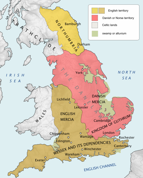
England and Wales at the time of the Treaty of Chippenham (AD 878)
摘要
[編輯]| 描述 |
English: England and Wales at the time of the Treaty of Chippenham (AD 878) |
| 日期 | |
| 來源 |
個人作品,使用:
|
| 作者 | Hel-hama |
| 其他版本 |
[]
|


.svg)


授權條款
[編輯]
我,本作品的著作權持有者,決定用以下授權條款發佈本作品:
此檔案採用共享創意 姓名標示-相同方式分享 3.0 未在地化版本授權條款。
- 您可以自由:
- 分享 – 複製、發佈和傳播本作品
- 重新修改 – 創作演繹作品
- 惟需遵照下列條件:
- 姓名標示 – 您必須指名出正確的製作者,和提供授權條款的連結,以及表示是否有對內容上做出變更。您可以用任何合理的方式來行動,但不得以任何方式表明授權條款是對您許可或是由您所使用。
- 相同方式分享 – 如果您利用本素材進行再混合、轉換或創作,您必須基於如同原先的相同或兼容的條款,來分布您的貢獻成品。
檔案歷史
點選日期/時間以檢視該時間的檔案版本。
| 日期/時間 | 縮圖 | 尺寸 | 用戶 | 備註 | |
|---|---|---|---|---|---|
| 目前 | 2020年8月14日 (五) 17:41 | | 988 × 1,229(1.54 MB) | Rob984(對話 | 貢獻) | fixed typo |
| 2020年8月12日 (三) 21:18 |  | 988 × 1,229(1.54 MB) | Þjarkur(對話 | 貢獻) | Reverting Rob984's change because it included a typo. If someone can reinstate his edit without the typo, that would be ideal. | |
| 2019年12月9日 (一) 16:31 |  | 988 × 1,229(1.54 MB) | Rob984(對話 | 貢獻) | "Northumberland" > "Northumbria". Not aware of usage of the modern-day's county's name in this historical context. | |
| 2019年5月22日 (三) 12:55 |  | 988 × 1,229(1.54 MB) | Þjarkur(對話 | 貢獻) | Make the colour of the area stand out more, the colours were too similar before to be able to discern | |
| 2012年7月8日 (日) 14:53 |  | 988 × 1,229(1.54 MB) | Hel-hama(對話 | 貢獻) | topography added | |
| 2012年6月13日 (三) 18:17 |  | 565 × 710(432 KB) | Hel-hama(對話 | 貢獻) | colours, borders | |
| 2012年6月13日 (三) 17:57 |  | 565 × 710(425 KB) | Hel-hama(對話 | 貢獻) | improved text | |
| 2012年6月13日 (三) 17:55 |  | 565 × 710(282 KB) | Hel-hama(對話 | 貢獻) |
無法覆蓋此檔案。
檔案用途
下列11個頁面有用到此檔案:
全域檔案使用狀況
以下其他 wiki 使用了這個檔案:
- ar.wikipedia.org 的使用狀況
- arz.wikipedia.org 的使用狀況
- azb.wikipedia.org 的使用狀況
- bg.wikipedia.org 的使用狀況
- cs.wikipedia.org 的使用狀況
- da.wikipedia.org 的使用狀況
- el.wikipedia.org 的使用狀況
- en.wikipedia.org 的使用狀況
- History of England
- Wessex
- 878
- Northumbria
- Danelaw
- Bernicia
- Battle of Edington
- Æthelwold ætheling
- Northern England
- History of Anglo-Saxon England
- Portal:England
- A Gest of Robyn Hode
- Kingdom of East Anglia
- Viking expansion
- Wikipedia:Graphics Lab/Map workshop/Archive/Jan 2014
- User:Dudley Miles/sandbox2
- English surnames of Norse origin
- Northumbria (modern)
- User:Alfielove14/sandbox
- History of monarchy in the United Kingdom
- Battle of Benfleet
- Government in Anglo-Saxon England
- en.wikiquote.org 的使用狀況
- es.wikipedia.org 的使用狀況
- et.wikipedia.org 的使用狀況
檢視此檔案的更多全域使用狀況。