File:Englebright Lake (6217894829).jpg
跳转到导航
跳转到搜索

本预览的尺寸:800 × 533像素。 其他分辨率:320 × 213像素 | 640 × 427像素 | 1,024 × 683像素 | 1,280 × 853像素 | 2,560 × 1,707像素 | 5,616 × 3,744像素。
原始文件 (5,616 × 3,744像素,文件大小:10.76 MB,MIME类型:image/jpeg)
说明
说明
添加一行文字以描述该文件所表现的内容
摘要
[编辑].jpg&action=edit§ion=1)
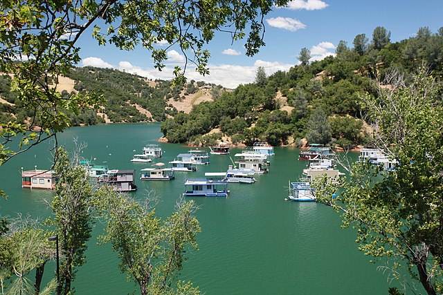
| 描述 | Boating, fishing and boat-in camping are some of the recreational opportunities at Englebright Lake near Marysville, Calif., shown on June 10, 2010. Formed by Englebright Dam the lake is 9 miles long with a surface area of 815 acres, an elevation of 527 feet and 24 miles of shoreline. Completed by the U.S. Army Corps of Engineers Sacramento District in 1941, the dam was authorized by Congress for the storage of hydraulic gold mining debris on the Yuba River. The concrete arch dam spans 1,142 feet across and is 260 feet high. The lake and dam are managed by the Sacramento District. (U.S. Army Photo/ Michael J. Nevins) |
| 日期 | |
| 来源 | Englebright Lake |
| 作者 | U.S. Army Corps of Engineers Sacramento District |
| 相机位置 | | 在以下服务上查看本图像和附近其他图像: OpenStreetMap |
|---|
.jpg¶ms=039.244352_N_-121.268463_E_globe:Earth_type:camera_source:Flickr_&language=zh-cn)
许可协议
[编辑].jpg&action=edit§ion=2)
This image or file is a work of a U.S. Army Corps of Engineers soldier or employee, taken or made as part of that person's official duties. As a work of the U.S. federal government, the image is in the public domain.
|
| 这幅图片原始出处为Flickr的https://flickr.com/photos/52057813@N07/6217894829 ,作者为USACE-Sacramento District 。经机器人FlickreviewR在2016年10月12日审查后确定为采用United States Government Work的协议授权使用。 |
文件历史
点击某个日期/时间查看对应时刻的文件。
| 日期/时间 | 缩略图 | 大小 | 用户 | 备注 | |
|---|---|---|---|---|---|
| 当前 | 2016年10月12日 (三) 06:19 | | 5,616 × 3,744(10.76 MB) | Vanished Account Byeznhpyxeuztibuo(留言 | 贡献) | Transferred from Flickr via Flickr2Commons |
您不可以覆盖此文件。
文件用途
没有页面使用本文件。
全域文件用途
以下其他wiki使用此文件:
- azb.wikipedia.org上的用途
- en.wikipedia.org上的用途
- eo.wikipedia.org上的用途
- fr.wikipedia.org上的用途
- it.wikipedia.org上的用途
- zh.wikipedia.org上的用途
.jpg&oldid=911892678)