File:English regions 2009.svg
跳至導覽
跳至搜尋

此 SVG 檔案的 PNG 預覽的大小:494 × 600 像素。 其他解析度:198 × 240 像素 | 395 × 480 像素 | 633 × 768 像素 | 843 × 1,024 像素 | 1,687 × 2,048 像素 | 1,108 × 1,345 像素。
原始檔案 (SVG 檔案,表面大小:1,108 × 1,345 像素,檔案大小:365 KB)
說明
說明
添加單行說明來描述出檔案所代表的內容
摘要
[編輯]
| 描述 |
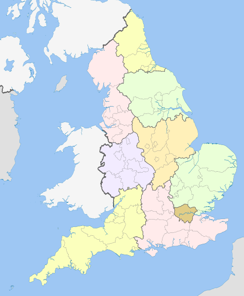
English: Map showing the Regions of England and the constituent metropolitan and non-metropolitan counties, in 2009.
Equirectangular map projection on WGS 84 datum, with N/S stretched 170% Geographic limits:
|
| 日期 | (UTC) |
| 來源 |
本檔案衍生自: English metropolitan and non-metropolitan counties 2010.svg:  |
| 作者 |
|
| 這是一張修飾過的圖片,即本圖片是用軟體修改過後的版本,修改的方式或內容有:recoloured with some thicker boundary lines。原版圖片來源:English metropolitan and non-metropolitan counties 2010.svg。修改者:Dr Greg。
|
授權條款
[編輯]
我,本作品的著作權持有者,決定用以下授權條款發佈本作品:
此檔案採用共享創意 姓名標示-相同方式分享 3.0 未在地化版本授權條款。
姓名標示: Nilfanion and Dr Greg
- 您可以自由:
- 分享 – 複製、發佈和傳播本作品
- 重新修改 – 創作演繹作品
- 惟需遵照下列條件:
- 姓名標示 – 您必須指名出正確的製作者,和提供授權條款的連結,以及表示是否有對內容上做出變更。您可以用任何合理的方式來行動,但不得以任何方式表明授權條款是對您許可或是由您所使用。
- 相同方式分享 – 如果您利用本素材進行再混合、轉換或創作,您必須基於如同原先的相同或兼容的條款,來分布您的貢獻成品。

|
已授權您依據自由軟體基金會發行的無固定段落、封面文字和封底文字GNU自由文件授權條款1.2版或任意後續版本,對本檔進行複製、傳播和/或修改。該協議的副本列在GNU自由文件授權條款中。 |
您可以選擇您需要的授權條款。
原始上傳日誌
[編輯]
This image is a derivative work of the following images:
- File:English_metropolitan_and_non-metropolitan_counties_2010.svg licensed with Cc-by-sa-3.0, GFDL
- 2010-11-23T22:01:59Z Nilfanion 1108x1345 (340057 Bytes) England only
- 2010-11-23T22:00:28Z Nilfanion 1108x1345 (376231 Bytes) {{Information |Description=Map showing the [[w:Metropolitan and non-metropolitan counties of England|Metropolitan and non-metropolitan counties of England]], in 2010. Equirectangular map projection on WGS 84 datum, with N/S
Uploaded with derivativeFX
檔案歷史
點選日期/時間以檢視該時間的檔案版本。
| 日期/時間 | 縮圖 | 尺寸 | 用戶 | 備註 | |
|---|---|---|---|---|---|
| 目前 | 2012年4月21日 (六) 20:04 | | 1,108 × 1,345(365 KB) | Dr Greg(對話 | 貢獻) | == {{int:filedesc}} == {{Information |Description={{en|Map showing the en:Regions of England and the constituent metropolitan and non-metropolitan counties, in 2009. Equirectangular m... |
無法覆蓋此檔案。
檔案用途
下列2個頁面有用到此檔案:
全域檔案使用狀況
以下其他 wiki 使用了這個檔案:
- ban.wikipedia.org 的使用狀況
- bg.wikipedia.org 的使用狀況
- bs.wikipedia.org 的使用狀況
- en.wikipedia.org 的使用狀況
- List of forests in the United Kingdom
- Subdivisions of England
- Regional assembly (England)
- Regional development agency
- Lists of schools in England
- User:Ric36/Sandbox
- Talk:Politics of England
- Template:England Labelled Map
- Health in England
- United Kingdom constitutional law
- Local authority leaders' board
- Regions of England
- Constitution of the United Kingdom
- Category:People by region in England
- Category:Cities in England by region
- Category:NUTS 1 statistical regions of England
- Devolution in the United Kingdom
- User talk:Iridescent/Archive 17
- Category:British school stubs
- User:Ric36/sandbox
- User:Bermicourt/Template:Lists of hills of English counties
- List of British regions by life expectancy
- es.wikipedia.org 的使用狀況
- fo.wikipedia.org 的使用狀況
- fr.wikipedia.org 的使用狀況
- hi.wikipedia.org 的使用狀況
- id.wikipedia.org 的使用狀況
- it.wikipedia.org 的使用狀況
- ja.wikipedia.org 的使用狀況
- ja.wikibooks.org 的使用狀況
- lv.wikipedia.org 的使用狀況
- mr.wikipedia.org 的使用狀況
- pl.wikipedia.org 的使用狀況
- pnb.wikipedia.org 的使用狀況
檢視此檔案的更多全域使用狀況。