File:English regions 2009.svg
跳转到导航
跳转到搜索

此SVG文件的PNG预览的大小:494 × 600像素。 其他分辨率:198 × 240像素 | 395 × 480像素 | 633 × 768像素 | 843 × 1,024像素 | 1,687 × 2,048像素 | 1,108 × 1,345像素。
原始文件 (SVG文件,尺寸为1,108 × 1,345像素,文件大小:365 KB)
说明
说明
添加一行文字以描述该文件所表现的内容
摘要
[编辑]
| 描述 |
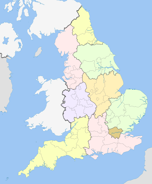
English: Map showing the Regions of England and the constituent metropolitan and non-metropolitan counties, in 2009.
Equirectangular map projection on WGS 84 datum, with N/S stretched 170% Geographic limits:
|
| 日期 | (UTC) |
| 来源 |
本文件衍生自: English metropolitan and non-metropolitan counties 2010.svg:  |
| 作者 |
|
| 这是一张修改过的图片,这意味着它已在原版本的基础上通过软件进行了编辑,改动内容:recoloured with some thicker boundary lines。其原始版本为:English metropolitan and non-metropolitan counties 2010.svg。修改者:Dr Greg。
|
许可协议
[编辑]
我,本作品著作权人,特此采用以下许可协议发表本作品:
本文件采用知识共享署名-相同方式共享 3.0 未本地化版本许可协议授权。
署名: Nilfanion and Dr Greg
- 您可以自由地:
- 共享 – 复制、发行并传播本作品
- 修改 – 改编作品
- 惟须遵守下列条件:
- 署名 – 您必须对作品进行署名,提供授权条款的链接,并说明是否对原始内容进行了更改。您可以用任何合理的方式来署名,但不得以任何方式表明许可人认可您或您的使用。
- 相同方式共享 – 如果您再混合、转换或者基于本作品进行创作,您必须以与原先许可协议相同或相兼容的许可协议分发您贡献的作品。

|
已授权您依据自由软件基金会发行的无固定段落及封面封底文字(Invariant Sections, Front-Cover Texts, and Back-Cover Texts)的GNU自由文件许可协议1.2版或任意后续版本的条款,复制、传播和/或修改本文件。该协议的副本请见“GNU Free Documentation License”。 |
您可以选择您需要的许可协议。
原始上传日志
[编辑]
This image is a derivative work of the following images:
- File:English_metropolitan_and_non-metropolitan_counties_2010.svg licensed with Cc-by-sa-3.0, GFDL
- 2010-11-23T22:01:59Z Nilfanion 1108x1345 (340057 Bytes) England only
- 2010-11-23T22:00:28Z Nilfanion 1108x1345 (376231 Bytes) {{Information |Description=Map showing the [[w:Metropolitan and non-metropolitan counties of England|Metropolitan and non-metropolitan counties of England]], in 2010. Equirectangular map projection on WGS 84 datum, with N/S
Uploaded with derivativeFX
文件历史
点击某个日期/时间查看对应时刻的文件。
| 日期/时间 | 缩略图 | 大小 | 用户 | 备注 | |
|---|---|---|---|---|---|
| 当前 | 2012年4月21日 (六) 20:04 | | 1,108 × 1,345(365 KB) | Dr Greg(留言 | 贡献) | == {{int:filedesc}} == {{Information |Description={{en|Map showing the en:Regions of England and the constituent metropolitan and non-metropolitan counties, in 2009. Equirectangular m... |
您不可以覆盖此文件。
文件用途
全域文件用途
以下其他wiki使用此文件:
- ban.wikipedia.org上的用途
- bg.wikipedia.org上的用途
- bs.wikipedia.org上的用途
- en.wikipedia.org上的用途
- List of forests in the United Kingdom
- Subdivisions of England
- Regional assembly (England)
- Regional development agency
- Lists of schools in England
- User:Ric36/Sandbox
- Talk:Politics of England
- Template:England Labelled Map
- Health in England
- United Kingdom constitutional law
- Local authority leaders' board
- Regions of England
- Constitution of the United Kingdom
- Category:People by region in England
- Category:Cities in England by region
- Category:NUTS 1 statistical regions of England
- Devolution in the United Kingdom
- User talk:Iridescent/Archive 17
- Category:British school stubs
- User:Ric36/sandbox
- User:Bermicourt/Template:Lists of hills of English counties
- List of British regions by life expectancy
- es.wikipedia.org上的用途
- fo.wikipedia.org上的用途
- fr.wikipedia.org上的用途
- hi.wikipedia.org上的用途
- id.wikipedia.org上的用途
- it.wikipedia.org上的用途
- ja.wikipedia.org上的用途
- ja.wikibooks.org上的用途
- lv.wikipedia.org上的用途
- mr.wikipedia.org上的用途
- pl.wikipedia.org上的用途
- pnb.wikipedia.org上的用途
查看此文件的更多全域用途。