File:Eratosthenes' method for determining the size of the Earth.svg
پرش به ناوبری
پرش به جستجو

حجم پیشنمایش PNG این SVG file:۴۳۱ × ۶۰۰ پیکسل کیفیتهای دیگر: ۱۷۲ × ۲۴۰ پیکسل | ۳۴۵ × ۴۸۰ پیکسل | ۵۵۲ × ۷۶۸ پیکسل | ۷۳۶ × ۱٬۰۲۴ پیکسل | ۱٬۴۷۲ × ۲٬۰۴۸ پیکسل | ۶۲۶ × ۸۷۱ پیکسل.
پروندهٔ اصلی (پروندهٔ اسویجی، با ابعاد ۶۲۶ × ۸۷۱ پیکسل، اندازهٔ پرونده: ۱۲۹ کیلوبایت)
گزینهها
عنوان
شرحی یکخطی از محتوای این فایل اضافه کنید
| توضیح |
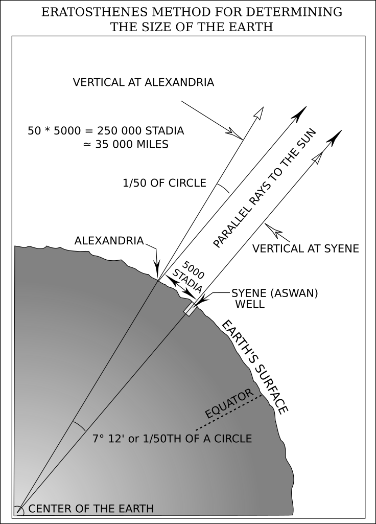
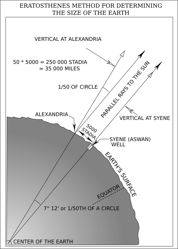
English: taken from the public domain source Geodesy for the Layman at http://www.ngs.noaa.gov/PUBS_LIB/Geodesy4Layman/TR80003A.HTM#ZZ4 Category:Images of Earth |
| تاریخ | (UTC) |
| منبع | |
| پدیدآور |
|
| این یک عکس دستکاری شده است به این معنی که به صورت دیجیتالی از نسخهٔ اصلی تغییر یافتهاست. تغییرها: Redraw of pixel (png) image as vector (svg). اصل آن را میتوان در اینجا مشاهده کرد: Eratosthenes' method for determining the size of the Earth.png. تغییرها توسط Gregors انجام شدهاست.
|
This image is in the public domain because it contains materials that originally came from the U.S. National Oceanic and Atmospheric Administration, taken or made as part of an employee's official duties.
|
سیاهه بارگذاری اصلی
[ویرایش]
This image is a derivative work of the following images:
- File:Eratosthenes'_method_for_determining_the_size_of_the_Earth.png licensed with PD-USGov-NOAA
- 2011-01-14T10:07:47Z Gregors 667x929 (133526 Bytes) {{Information |Description={{en|taken from the public domain source Geodesy for the Layman at http://www.ngs.noaa.gov/PUBS_LIB/Geodesy4Layman/TR80003A.HTM#ZZ4 [[:en:Category:Images of Earth|Category:Images of Earth]]}} |Sour
Uploaded with derivativeFX
تاریخچهٔ پرونده
روی تاریخ/زمانها کلیک کنید تا نسخهٔ مربوط به آن هنگام را ببینید.
| تاریخ/زمان | بندانگشتی | ابعاد | کاربر | توضیح | |
|---|---|---|---|---|---|
| کنونی | ۲۵ اوت ۲۰۱۱، ساعت ۱۳:۲۶ | | ۶۲۶ در ۸۷۱ (۱۲۹ کیلوبایت) | Gregors (بحث | مشارکتها) | {{Information |Description={{en|taken from the public domain source Geodesy for the Layman at http://www.ngs.noaa.gov/PUBS_LIB/Geodesy4Layman/TR80003A.HTM#ZZ4 Category:Images of Earth}} |Source=*[[:File:Eratosthenes'_meth |
نمیتوانید این پرونده را رونویسی کنید.
کاربرد پرونده
این پرونده در هیچ صفحهای به کار نرفته است.
کاربرد سراسری پرونده
ویکیهای دیگر زیر از این پرونده استفاده میکنند:
- کاربرد در ar.wikipedia.org
- کاربرد در en.wikipedia.org
- کاربرد در fa.wikipedia.org
- کاربرد در id.wikipedia.org
- کاربرد در my.wikipedia.org
- کاربرد در ro.wikipedia.org
- کاربرد در sl.wikipedia.org
- کاربرد در zh.wikipedia.org