File:Erdfunkstelle Raisting 5.jpg
跳转到导航
跳转到搜索

本预览的尺寸:800 × 286像素。 其他分辨率:320 × 114像素 | 640 × 229像素 | 1,024 × 366像素 | 1,280 × 457像素 | 4,200 × 1,500像素。
原始文件 (4,200 × 1,500像素,文件大小:5.29 MB,MIME类型:image/jpeg)
说明
说明
添加一行文字以描述该文件所表现的内容
Other versions:


| 相机位置 | | 在以下服务上查看本图像和附近其他图像: OpenStreetMap |
|---|
| 描述 |
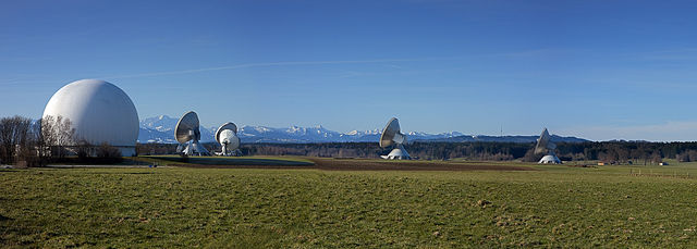
Deutsch: In Reisting, in der Nähe des Ammersees (Bayern), befindet sich deutschlandweit die größte Erdfunkstelle für Funkanwendungen Satellitenfunk. Die Parabolantennen zur Funkkommunikation mit den Weltraumfunkstellen sind als Wahrzeichen weithin sichtbar.
English: The biggest facility for satellite communication in Raisting, Bavaria, Germany.
Français : Le plus gros centre de communication satellitaire à Raisting, en Bavière (Allemagne). |
| 日期 | |
| 来源 | 自己的作品 |
| 作者 |
Richard Bartz, Munich aka Makro Freak |
| 授权 (二次使用本文件) |
本文件采用知识共享署名-相同方式共享 2.5 通用许可协议授权。
|
|
|
文件历史
点击某个日期/时间查看对应时刻的文件。
| 日期/时间 | 缩略图 | 大小 | 用户 | 备注 | |
|---|---|---|---|---|---|
| 当前 | 2008年4月1日 (二) 14:41 | 4,200 × 1,500(5.29 MB) | Richard Bartz(留言 | 贡献) | '''Other versions:''' <gallery> Image:Erdfunkstelle Raisting 1.jpg Image:Erdfunkstelle Raisting 2.jpg Image:Erdfunkstelle Raisting 3.jpg </gallery> {{Location|47|53|55|N|11|06|42|E}} {{Information |Description = {{de|Die größte Erdfunkstelle der We |
您不可以覆盖此文件。
文件用途
以下8个页面使用本文件:
- Erdfunkstelle Raisting
- User:Richard Bartz/Archive 1 09
- Commons:Quality images/Subject/Objects/Industrial/Archive 2008-2015
- Commons:Quality images candidates/Archives April 2008
- Commons:Quality images candidates/Archives February 2009
- File:Erdfunkstelle Raisting 1.jpg
- File:Erdfunkstelle Raisting 2.jpg
- File:Erdfunkstelle Raisting 3.jpg
全域文件用途
以下其他wiki使用此文件:
- ar.wikipedia.org上的用途
- de.wikipedia.org上的用途
- en.wikipedia.org上的用途
- eo.wikipedia.org上的用途
- fr.wikipedia.org上的用途
- lb.wikipedia.org上的用途
- nl.wikipedia.org上的用途
- ru.wikipedia.org上的用途
- uk.wikipedia.org上的用途
- www.wikidata.org上的用途
- zh.wikipedia.org上的用途