File:Erebus 360 L257atc-B652R1.jpg
跳至導覽
跳至搜尋

預覽大小:800 × 211 像素。 其他解析度:320 × 84 像素 | 640 × 168 像素 | 1,024 × 270 像素 | 1,280 × 337 像素 | 2,560 × 674 像素 | 22,780 × 5,996 像素。
原始檔案 (22,780 × 5,996 像素,檔案大小:74.36 MB,MIME 類型:image/jpeg)
說明
說明
添加單行說明來描述出檔案所代表的內容
| 警告 | 部分瀏覽器在瀏覽此圖片的完整大小時可能會遇到困難:該圖片中有數量巨大的像素點,可能無法完全載入或者導致您的瀏覽器停止回應。 |
|---|
摘要[編輯]
| 描述 |
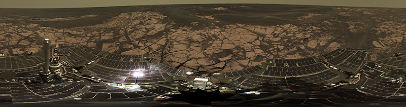
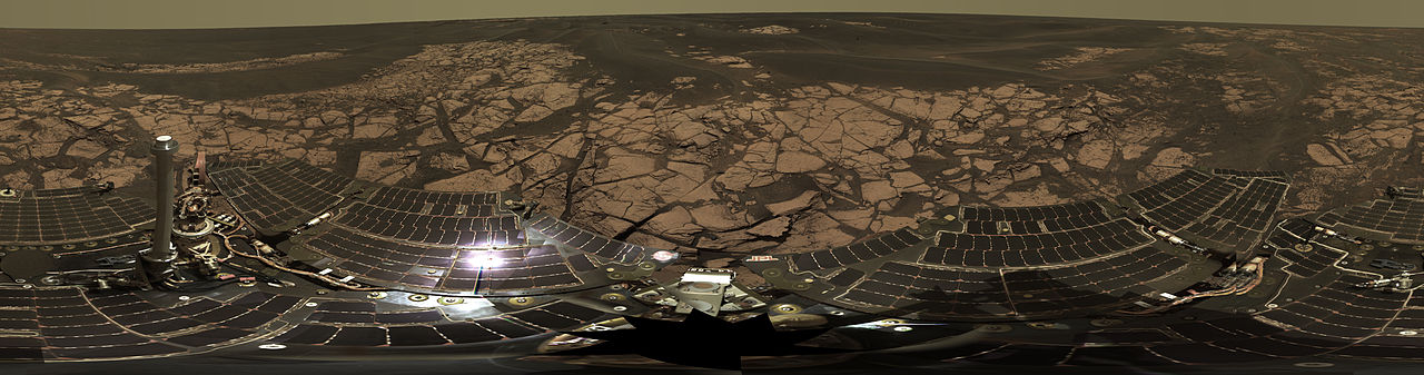
English: This is the Opportunity panoramic camera's "Erebus Rim" panorama, acquired on sols 652 to 663 (Nov. 23 to Dec. 5, 2005 ), as NASA's Mars Exploration Rover Opportunity was exploring sand dunes and outcrop rocks in Meridiani Planum. The panorama originally consisted of 635 separate images in four different Pancam filters, and covers 360 degrees of terrain around the rover and the full rover deck. Since the time that this panorama was acquired, and while engineers have been diagnosing and testing Opportunity's robotic arm, the panorama has been expanded to include more than 1,300 images of this terrain through all of the Pancam multispectral filters. It is the largest panorama acquired by either rover during the mission.
The panorama shown here is an approximate true-color rendering using Pancam's 750 nanometer, 530 nanometer and 430 nanometer filters. It is presented here as a cylindrical projection. Image-to-image seams have been eliminated from the sky portion of the mosaic to better simulate the vista a person standing on Mars would see. This panorama provides the team's highest resolution view yet of the finely-layered outcrop rocks, wind ripples, and small cobbles and grains along the rim of the wide but shallow "Erebus" crater. Once the arm diagnostics and testing are completed, the team hopes to explore other layered outcrop rocks at Erebus and then eventually continue southward toward the large crater known as "Victoria." |
| 日期 | 在2005年11月23日到2005年12月5日之間 |
| 來源 | http://marsrovers.jpl.nasa.gov/gallery/press/opportunity/20060104a.html / http://photojournal.jpl.nasa.gov/catalog/PIA03270 |
| 作者 | NASA/JPL-Caltech/Cornell |
| 360° | 瀏覽環景圖請使用360° 環景瀏覽器
|
|---|
| 此標籤不表示文件的著作權狀態。任何文件在附有此標籤的同時還需要一個有效的著作權標籤。請參閱許可協議說明頁面以了解更多資訊。 其他語言:
|
授權條款[編輯]
| 本作品由NASA創作,屬於公有領域。根據NASA的版權政策:“NASA的創作除非另有聲明否則不受版權保護。”(參見:Template:PD-USGov/zh,NASA版權政策或JPL圖像使用政策) | ||
 |
警告:
|
檔案歷史
點選日期/時間以檢視該時間的檔案版本。
| 日期/時間 | 縮圖 | 尺寸 | 使用者 | 備註 | |
|---|---|---|---|---|---|
| 目前 | 2013年2月22日 (五) 06:00 | 22,780 × 5,996(74.36 MB) | Huntster(留言 | 貢獻) | Original super-resolution version of image. | |
| 2006年1月15日 (日) 10:50 | 3,000 × 790(523 KB) | JamesHoadley(留言 | 貢獻) | w:Erebus crater. From [http://marsrovers.jpl.nasa.gov/gallery/press/opportunity/20060104a.html]. Original caption: <blockquote>'''On the Rim of 'Erebus'''' This is the Opportunity panoramic camera's "Erebus Rim" panorama, acquired on sols 652 to 66 |
無法覆蓋此檔案。
檔案用途
沒有使用此檔案的頁面。
全域檔案使用狀況
以下其他 wiki 使用了這個檔案:
- ast.wikipedia.org 的使用狀況
- bs.wikipedia.org 的使用狀況
- de.wikipedia.org 的使用狀況
- en.wikipedia.org 的使用狀況
- es.wikipedia.org 的使用狀況
- fr.wikipedia.org 的使用狀況
- hi.wikipedia.org 的使用狀況
- it.wikipedia.org 的使用狀況
- ja.wikipedia.org 的使用狀況
- ko.wikipedia.org 的使用狀況
- lb.wikipedia.org 的使用狀況
- mn.wikipedia.org 的使用狀況
- pt.wikipedia.org 的使用狀況
- ro.wikipedia.org 的使用狀況
- ru.wikipedia.org 的使用狀況
- uk.wikipedia.org 的使用狀況
- zh.wikipedia.org 的使用狀況