File:Erosionsrinnen (Millimeter, Sand).jpg
Jump to navigation
Jump to search

Size of this preview: 228 × 599 pixels. Other resolutions: 91 × 240 pixels | 182 × 480 pixels | 292 × 768 pixels | 390 × 1,024 pixels | 1,519 × 3,989 pixels.
Original file (1,519 × 3,989 pixels, file size: 4.41 MB, MIME type: image/jpeg)
Captions
Captions
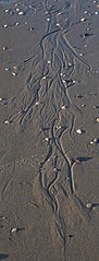
Erosion channels only millimetres wide on a sandy slope at low tide
Summary[edit]
.jpg&action=edit§ion=1)
| Description |
Deutsch: Man sieht Fließrinnenstrukturen im Sand. Die ganze Struktur hatte eine Länge im Meterbereich. Die Breite einzelner Rinnen lag bei wenigen Millimetern. Das starke Gefälle lief vom oberen zum unteren Bildrand hin. Auffällig ist, das kleinere Rinnen stets mit einem Sandhaufen enden und sich nicht als Rinne bis zum Meer fortsetzen. Möglicherweise floß hier stark sandhaltiges Wasser mit hoher Fließgeschwindigkeit. Das Wasser versickerte dann vielleicht im sandigen Untergrund. Der mitgeführte Sand blieb dann als Haufen zurück an der Stelle, an der nicht mehr genug fließendes Wasser für eine Mitnahme vorhanden war. Die Aufnahme entstand am 21. Juli 2020 am Westende der Nordseeinsel Wangeroogel. |
| Date | |
| Source | Own work |
| Author | Rhetos |
Licensing[edit]
.jpg&action=edit§ion=2)
I, the copyright holder of this work, hereby publish it under the following license:
| This file is made available under the Creative Commons CC0 1.0 Universal Public Domain Dedication. | |
| The person who associated a work with this deed has dedicated the work to the public domain by waiving all of their rights to the work worldwide under copyright law, including all related and neighboring rights, to the extent allowed by law. You can copy, modify, distribute and perform the work, even for commercial purposes, all without asking permission.
|
File history
Click on a date/time to view the file as it appeared at that time.
| Date/Time | Thumbnail | Dimensions | User | Comment | |
|---|---|---|---|---|---|
| current | 07:21, 6 June 2021 | 1,519 × 3,989 (4.41 MB) | Rhetos (talk | contribs) | Uploaded own work with UploadWizard |
You cannot overwrite this file.
File usage on Commons
The following page uses this file:
.jpg&oldid=858718745)