File:EtoshaPan 2005-06 comparison.jpg
跳转到导航
跳转到搜索

本预览的尺寸:414 × 600像素。 其他分辨率:166 × 240像素 | 540 × 782像素。
原始文件 (540 × 782像素,文件大小:103 KB,MIME类型:image/jpeg)
说明
说明
添加一行文字以描述该文件所表现的内容
摘要
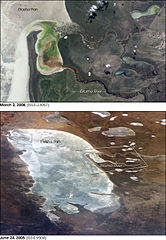
[编辑]| 描述 | Two images of the w:Etosha pan in Namibia. The upper view (March 2006) shows the point where the Ekuma River flows into the salt lake; the lower regional image (June 2005) shows the same inlet—but dry—on the north shore of Etosha Pan. Both photos taken from the International Space Station. |
| 日期 | |
| 来源 | http://earthobservatory.nasa.gov/Newsroom/NewImages/images.php3?img_id=17261 |
| 作者 | ISS Crew Earth Observations experiment and the Image Science & Analysis Group, Johnson Space Center. Images cropped, cleaned up, and labelled by NASA Earth Observatory. |
| 授权 (二次使用本文件) |
US government, public domain |
| 其他版本 | Links to original images available at source URL. |
.jpg)
许可协议
[编辑]
| 本文件完全由NASA创作,在美国属于公有领域。根据NASA的版权方针,NASA的材料除非另有声明否则不受版权保护。(参见Template:PD-USGov/zh、NASA版权方针页面或JPL图片使用方针。) | ||
 |
警告:
|
文件历史
点击某个日期/时间查看对应时刻的文件。
| 日期/时间 | 缩略图 | 大小 | 用户 | 备注 | |
|---|---|---|---|---|---|
| 当前 | 2006年5月1日 (一) 16:07 | | 540 × 782(103 KB) | Holly Cheng(留言 | 贡献) | {{Information | Description=Two images of the w:Etosha pan in Namibia. The upper view (March 2006) shows the point where the Ekuma River flows into the salt lake; the lower regional image (June 2005) shows the same inlet—but dry—on the north shore |
您不可以覆盖此文件。
文件用途
全域文件用途
以下其他wiki使用此文件:
- af.wikipedia.org上的用途
- bg.wikipedia.org上的用途
- ca.wikipedia.org上的用途
- ceb.wikipedia.org上的用途
- en.wikipedia.org上的用途
- eo.wikipedia.org上的用途
- es.wikipedia.org上的用途
- fa.wikipedia.org上的用途
- fr.wikipedia.org上的用途
- lb.wikipedia.org上的用途
- pl.wikipedia.org上的用途
- sk.wikipedia.org上的用途
- sl.wikipedia.org上的用途
- www.wikidata.org上的用途
- zh.wikipedia.org上的用途