File:Eure-et-Loir et provinces.svg
Jump to navigation
Jump to search

Size of this PNG preview of this SVG file: 554 × 600 pixels. Other resolutions: 222 × 240 pixels | 443 × 480 pixels | 709 × 768 pixels | 946 × 1,024 pixels | 1,892 × 2,048 pixels | 1,113 × 1,205 pixels.
Original file (SVG file, nominally 1,113 × 1,205 pixels, file size: 366 KB)
Captions
Captions
Add a one-line explanation of what this file represents
Summary[edit]
| Description |
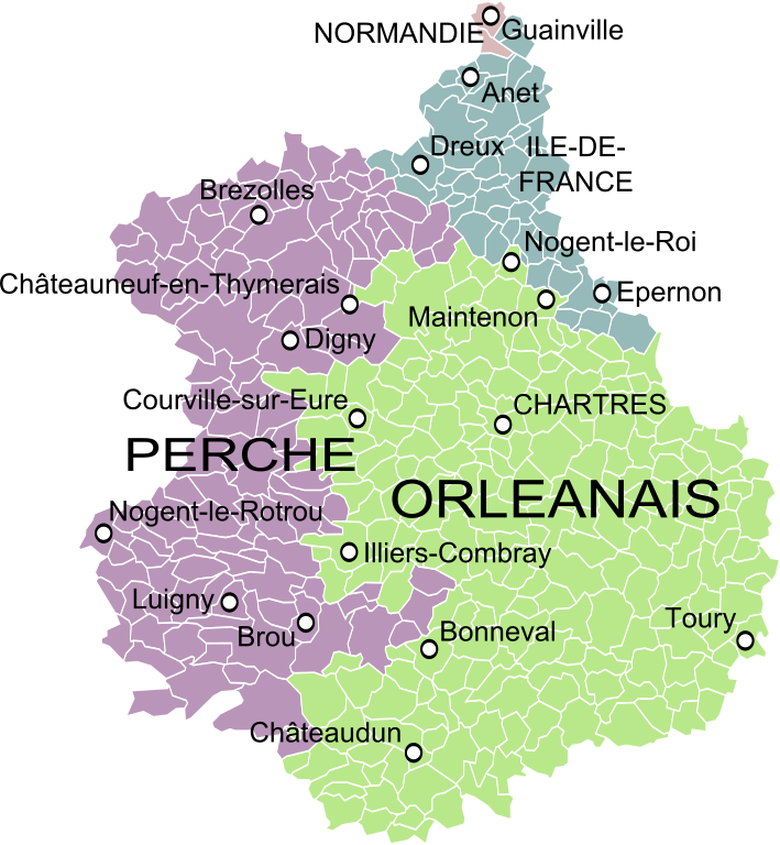
English: Map showing the French department of Eure-et-Loir and the former provinces that existed before 1790. Français : Carte de l'Eure-et-Loir montrant les provinces existant avant 1790. |
| Date | |
| Source |
Carte des Provinces du Maine et du Perche, Guillaume Delisle, 1719 ; Gouvernement général d'Orléanois, où se trouvent l'Orleanois propre, le Blaisois, le Gatinois, et la Beauce, qui comprend le Vendomois, le Dunois, et le pays chartrain, Robert de Vaugondy, 1753, et Gouvernement général de l'Isle de France divisé par pays, Robert de Vaugondy, 1754. Derivative works of this file: Blank Map of Eure-et-Loir Department, France, with Communes.svg by Poulpy |
| Author | Oie blanche |
Licensing[edit]
I, the copyright holder of this work, hereby publish it under the following license:
This file is licensed under the Creative Commons Attribution-Share Alike 3.0 Unported license.
- You are free:
- to share – to copy, distribute and transmit the work
- to remix – to adapt the work
- Under the following conditions:
- attribution – You must give appropriate credit, provide a link to the license, and indicate if changes were made. You may do so in any reasonable manner, but not in any way that suggests the licensor endorses you or your use.
- share alike – If you remix, transform, or build upon the material, you must distribute your contributions under the same or compatible license as the original.
File history
Click on a date/time to view the file as it appeared at that time.
| Date/Time | Thumbnail | Dimensions | User | Comment | |
|---|---|---|---|---|---|
| current | 06:29, 12 May 2013 | | 1,113 × 1,205 (366 KB) | Oie blanche (talk | contribs) | Minor edit. |
| 06:28, 12 May 2013 |  | 1,113 × 1,205 (339 KB) | Oie blanche (talk | contribs) | Text and size. | |
| 06:26, 12 May 2013 |  | 1,000 × 1,203 (259 KB) | Oie blanche (talk | contribs) | User created page with UploadWizard |
You cannot overwrite this file.
File usage on Commons
The following page uses this file:
File usage on other wikis
The following other wikis use this file:
- Usage on br.wikipedia.org
- Usage on el.wikipedia.org
- Usage on fr.wikipedia.org
- Usage on ja.wikipedia.org
- Usage on nl.wikipedia.org
- Usage on simple.wikipedia.org