File:Euro float map.png
Jump to navigation
Jump to search
No higher resolution available.
Euro_float_map.png (649 × 572 pixels, file size: 20 KB, MIME type: image/png)
Captions
Captions
Add a one-line explanation of what this file represents
Summary[edit]
| Description |
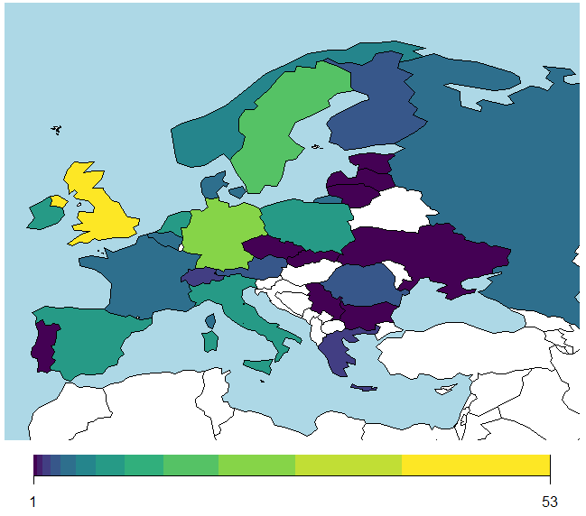
English: This map of recreational float centers in Europe was generated using data from https://floatationlocations.com/where-to-float/ in 2021. It is possible that some locations listed in the source data have gone out of business and also that some newer locations are unlisted. This map is intended to provide a summary of the population of floating in Europe. |
| Date | |
| Source | Own work |
| Author | Kleinhern |
Licensing[edit]
I, the copyright holder of this work, hereby publish it under the following license:
This file is licensed under the Creative Commons Attribution-Share Alike 4.0 International license.
- You are free:
- to share – to copy, distribute and transmit the work
- to remix – to adapt the work
- Under the following conditions:
- attribution – You must give appropriate credit, provide a link to the license, and indicate if changes were made. You may do so in any reasonable manner, but not in any way that suggests the licensor endorses you or your use.
- share alike – If you remix, transform, or build upon the material, you must distribute your contributions under the same or compatible license as the original.
File history
Click on a date/time to view the file as it appeared at that time.
| Date/Time | Thumbnail | Dimensions | User | Comment | |
|---|---|---|---|---|---|
| current | 15:56, 6 August 2023 | | 649 × 572 (20 KB) | Kleinhern (talk | contribs) | Uploaded while editing "Isolation tank" on en.wikipedia.org |
You cannot overwrite this file.
File usage on Commons
There are no pages that use this file.