File:Europe 1812 map ar.png
Jump to navigation
Jump to search
Size of this preview: 800 × 526 pixels. Other resolutions: 320 × 211 pixels | 640 × 421 pixels | 1,024 × 674 pixels | 1,280 × 842 pixels | 2,284 × 1,503 pixels.
Original file (2,284 × 1,503 pixels, file size: 1.18 MB, MIME type: image/png)
Captions
Captions
Add a one-line explanation of what this file represents
Summary[edit]
| Description |
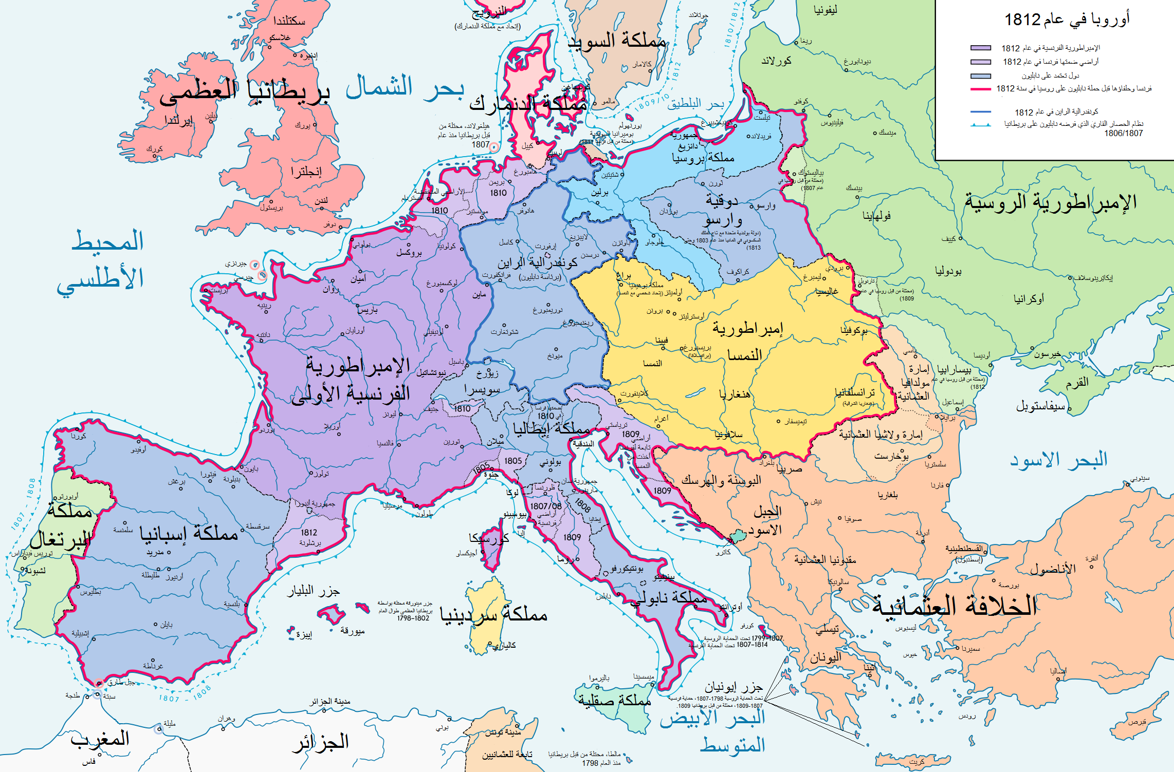
English: Europe in 1812 العربية : خريطة أوروبا في عام 1812 Deutsch: Europa 1812. Politische Ausgangslage vor Napeoleons Russlandfelzug. English: Europe in 1812. Political situation before Napoleon's Russian Campaign. |
| Date | |
| Source | Derivative from this file |
| Author | معتز الوحيشي |
| Other versions |
|


| This is a retouched picture, which means that it has been digitally altered from its original version. Modifications: Translated to Arabic - ﻋُﺮِﺑَﺖ. The original can be viewed here: Europe 1812 map en.png:
|
_en.png)
.png)
.jpg)
[[Category: ]]
Licensing[edit]
I, the copyright holder of this work, hereby publish it under the following license:
This file is licensed under the Creative Commons Attribution-Share Alike 3.0 Unported license.
- You are free:
- to share – to copy, distribute and transmit the work
- to remix – to adapt the work
- Under the following conditions:
- attribution – You must give appropriate credit, provide a link to the license, and indicate if changes were made. You may do so in any reasonable manner, but not in any way that suggests the licensor endorses you or your use.
- share alike – If you remix, transform, or build upon the material, you must distribute your contributions under the same or compatible license as the original.
File history
Click on a date/time to view the file as it appeared at that time.
| Date/Time | Thumbnail | Dimensions | User | Comment | |
|---|---|---|---|---|---|
| current | 06:59, 20 September 2020 | | 2,284 × 1,503 (1.18 MB) | معتز الوحيشي (talk | contribs) | =={{int:filedesc}}== {{Information |description= {{ar|1= خريطة أوروبا في عام 1812}} {{ar|1= تحت سيطرة نابليون بونابرت }} |date=2020-9-20 20:51:10 |source=Derivative from this file |source={{own}} |author= *Derivative: معتز الوحيشي |permission= |other versions= English }} {{RetouchedPicture|Translated to Arabic - ﻋُﺮِﺑَﺖ |editor= معتز الوحيشي |orig=Europe map 1812 en.png}} =={... |
You cannot overwrite this file.
File usage on Commons
The following page uses this file:
File usage on other wikis
The following other wikis use this file:
- Usage on ar.wikipedia.org