File:Europe 1812 map de.png
跳至導覽
跳至搜尋

預覽大小:800 × 526 像素。 其他解析度:320 × 211 像素 | 640 × 421 像素 | 1,024 × 674 像素 | 1,280 × 842 像素 | 2,284 × 1,503 像素。
原始檔案 (2,284 × 1,503 像素,檔案大小:1.13 MB,MIME 類型:image/png)
說明
說明
添加單行說明來描述出檔案所代表的內容
摘要
[編輯]| 描述 |
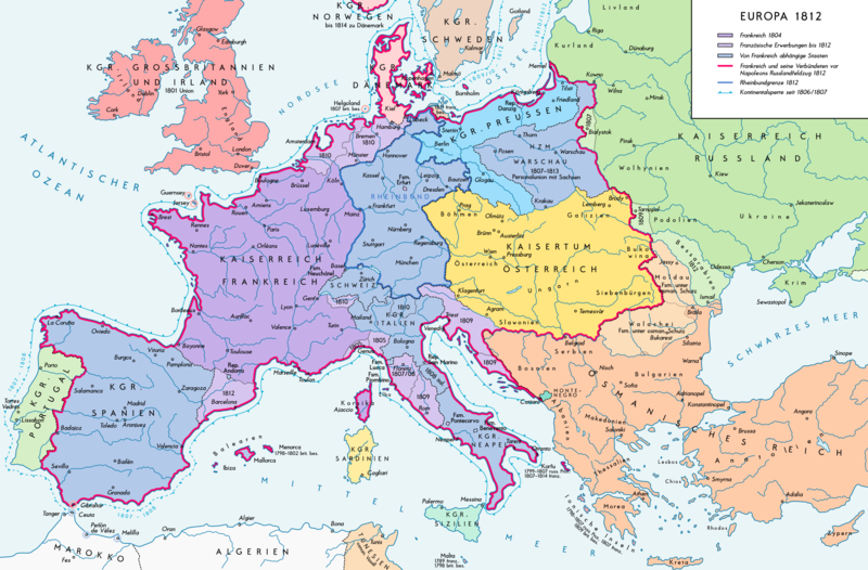
Deutsch: Europa 1812. Politische Ausgangslage vor Napeoleons Russlandfelzug. English: Europe in 1812. Political situation before Napoleon's Russian Campaign. |
| 日期 | |
| 來源 |
自己的作品. Source of Information: – Map «L’apogée de l’Empire Français (avant la campagne de Russie)» (Author unknown) Fehlerhafter Link: (Link) – Dr. Walter Leiserung (ed.): Historischer Weltatlas, Marix Verlag, Wiesbaden 2004, 國際標準書號 978-3-937715-59-9 – Zentralinstitut für Geschichte der Akademie der Wissenschaften der DDR (ed.): Atlas zur Geschichte, Band 1, VEB Hermann Haack, Gotha 1989, 國際標準書號 3-7301-0040-8 – Prof. Dr. Vadim Oswalt, Prof. Dr. Hans Ulrich Rudolf (ed.): Klett-Perthes Atlas zur Weltgeschichte, Ernst Klett Verlag, Stuttgart 2011, 國際標準書號 978-3-12-828194-0 – Ferenc Majoros u. Bernd Rill: Das Osmanische Reich 1300-1922. Die Geschichte einer Großmacht, Lzenzausgabe für Weltbild Verlag, Augsburg 2000, 國際標準書號 3-8289-0336-3 |
| 作者 | Alexander Altenhof |
| 其他版本 |
|

授權條款
[編輯]
我,本作品的著作權持有者,決定用以下授權條款發佈本作品:
此檔案採用創用CC 姓名標示-相同方式分享 3.0 未在地化版本授權條款。
- 您可以自由:
- 分享 – 複製、發佈和傳播本作品
- 重新修改 – 創作演繹作品
- 惟需遵照下列條件:
- 姓名標示 – 您必須指名出正確的製作者,和提供授權條款的連結,以及表示是否有對內容上做出變更。您可以用任何合理的方式來行動,但不得以任何方式表明授權條款是對您許可或是由您所使用。
- 相同方式分享 – 如果您利用本素材進行再混合、轉換或創作,您必須基於如同原先的相同或兼容的條款,來分布您的貢獻成品。
檔案歷史
點選日期/時間以檢視該時間的檔案版本。
| 日期/時間 | 縮圖 | 尺寸 | 使用者 | 備註 | |
|---|---|---|---|---|---|
| 目前 | 2016年9月11日 (日) 15:25 | | 2,284 × 1,503(1.13 MB) | KaterBegemot(留言 | 貢獻) | Border corrections at Thorn and Tarnopol area, minor kerning and positioning changes, smaller font at Swedish Pomerania |
| 2016年7月20日 (三) 00:48 |  | 2,284 × 1,503(1.14 MB) | KaterBegemot(留言 | 貢獻) | Added Bukovina / Marked Corfu as territory under French influence (red) / Correct position of city points of Basel, Geneva, Toulouse / Minor border corrections / Better kerning / Thinner map legend border | |
| 2016年7月14日 (四) 00:23 |  | 2,284 × 1,503(1.13 MB) | KaterBegemot(留言 | 貢獻) | Added P. of Neuchatel, Ekaterinoslav, Varna, Brăila / Corrected borders of Montenegro, Milan-Genoa area / Deleted border of map | |
| 2013年10月5日 (六) 21:33 |  | 2,293 × 1,512(1 MB) | KaterBegemot(留言 | 貢獻) | Corrected boundaries of Switzerland, Prussia and Circassia | |
| 2012年9月16日 (日) 17:56 |  | 2,293 × 1,512(1 MB) | KaterBegemot(留言 | 貢獻) | Minor fixes | |
| 2012年9月10日 (一) 15:50 |  | 2,293 × 1,512(1 MB) | KaterBegemot(留言 | 貢獻) | Corrections | |
| 2012年9月8日 (六) 16:31 |  | 2,293 × 1,512(1,019 KB) | KaterBegemot(留言 | 貢獻) | == {{int:filedesc}} == {{Information |Description= {{de|1=Europa 1812. Politische Ausgangslage vor Napeoleons Russlandfelzug.}}{{en|1=Europe in 1812. Political situation before Napoleon's Russian Campaign.}} |Source={{Own}}. Source of Information: </br... |
無法覆蓋此檔案。
檔案用途
下列2個頁面有用到此檔案:
全域檔案使用狀況
以下其他 wiki 使用了這個檔案:
- de.wikipedia.org 的使用狀況
- en.wikipedia.org 的使用狀況
- eu.wikipedia.org 的使用狀況
- zh.wikipedia.org 的使用狀況