File:Europe 1812 map de.png
跳转到导航
跳转到搜索

本预览的尺寸:800 × 526像素。 其他分辨率:320 × 211像素 | 640 × 421像素 | 1,024 × 674像素 | 1,280 × 842像素 | 2,284 × 1,503像素。
原始文件 (2,284 × 1,503像素,文件大小:1.13 MB,MIME类型:image/png)
说明
说明
添加一行文字以描述该文件所表现的内容
摘要
[编辑]| 描述 |
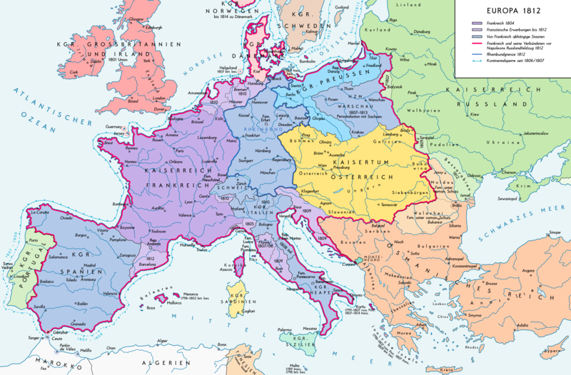
Deutsch: Europa 1812. Politische Ausgangslage vor Napeoleons Russlandfelzug. English: Europe in 1812. Political situation before Napoleon's Russian Campaign. |
| 日期 | |
| 来源 |
自己的作品. Source of Information: – Map «L’apogée de l’Empire Français (avant la campagne de Russie)» (Author unknown) Fehlerhafter Link: (Link) – Dr. Walter Leiserung (ed.): Historischer Weltatlas, Marix Verlag, Wiesbaden 2004, ISBN 978-3-937715-59-9 – Zentralinstitut für Geschichte der Akademie der Wissenschaften der DDR (ed.): Atlas zur Geschichte, Band 1, VEB Hermann Haack, Gotha 1989, ISBN 3-7301-0040-8 – Prof. Dr. Vadim Oswalt, Prof. Dr. Hans Ulrich Rudolf (ed.): Klett-Perthes Atlas zur Weltgeschichte, Ernst Klett Verlag, Stuttgart 2011, ISBN 978-3-12-828194-0 – Ferenc Majoros u. Bernd Rill: Das Osmanische Reich 1300-1922. Die Geschichte einer Großmacht, Lzenzausgabe für Weltbild Verlag, Augsburg 2000, ISBN 3-8289-0336-3 |
| 作者 | Alexander Altenhof |
| 其他版本 |
|

许可协议
[编辑]
我,本作品著作权人,特此采用以下许可协议发表本作品:
本文件采用知识共享署名-相同方式共享 3.0 未本地化版本许可协议授权。
- 您可以自由地:
- 共享 – 复制、发行并传播本作品
- 修改 – 改编作品
- 惟须遵守下列条件:
- 署名 – 您必须对作品进行署名,提供授权条款的链接,并说明是否对原始内容进行了更改。您可以用任何合理的方式来署名,但不得以任何方式表明许可人认可您或您的使用。
- 相同方式共享 – 如果您再混合、转换或者基于本作品进行创作,您必须以与原先许可协议相同或相兼容的许可协议分发您贡献的作品。
文件历史
点击某个日期/时间查看对应时刻的文件。
| 日期/时间 | 缩略图 | 大小 | 用户 | 备注 | |
|---|---|---|---|---|---|
| 当前 | 2016年9月11日 (日) 15:25 | | 2,284 × 1,503(1.13 MB) | KaterBegemot(留言 | 贡献) | Border corrections at Thorn and Tarnopol area, minor kerning and positioning changes, smaller font at Swedish Pomerania |
| 2016年7月20日 (三) 00:48 |  | 2,284 × 1,503(1.14 MB) | KaterBegemot(留言 | 贡献) | Added Bukovina / Marked Corfu as territory under French influence (red) / Correct position of city points of Basel, Geneva, Toulouse / Minor border corrections / Better kerning / Thinner map legend border | |
| 2016年7月14日 (四) 00:23 |  | 2,284 × 1,503(1.13 MB) | KaterBegemot(留言 | 贡献) | Added P. of Neuchatel, Ekaterinoslav, Varna, Brăila / Corrected borders of Montenegro, Milan-Genoa area / Deleted border of map | |
| 2013年10月5日 (六) 21:33 |  | 2,293 × 1,512(1 MB) | KaterBegemot(留言 | 贡献) | Corrected boundaries of Switzerland, Prussia and Circassia | |
| 2012年9月16日 (日) 17:56 |  | 2,293 × 1,512(1 MB) | KaterBegemot(留言 | 贡献) | Minor fixes | |
| 2012年9月10日 (一) 15:50 |  | 2,293 × 1,512(1 MB) | KaterBegemot(留言 | 贡献) | Corrections | |
| 2012年9月8日 (六) 16:31 |  | 2,293 × 1,512(1,019 KB) | KaterBegemot(留言 | 贡献) | == {{int:filedesc}} == {{Information |Description= {{de|1=Europa 1812. Politische Ausgangslage vor Napeoleons Russlandfelzug.}}{{en|1=Europe in 1812. Political situation before Napoleon's Russian Campaign.}} |Source={{Own}}. Source of Information: </br... |
您不可以覆盖此文件。
文件用途
以下2个页面使用本文件:
全域文件用途
以下其他wiki使用此文件:
- de.wikipedia.org上的用途
- en.wikipedia.org上的用途
- eu.wikipedia.org上的用途
- zh.wikipedia.org上的用途