File:Europe 814.png
Μετάβαση στην πλοήγηση
Πήδηση στην αναζήτηση

Μέγεθος αυτής της προεπισκόπησης: 777 × 600 εικονοστοιχεία . Άλλες αναλύσεις: 311 × 240 εικονοστοιχεία | 622 × 480 εικονοστοιχεία | 995 × 768 εικονοστοιχεία | 1.280 × 988 εικονοστοιχεία | 1.393 × 1.075 εικονοστοιχεία.
Πρωτότυπο αρχείο (1.393 × 1.075 εικονοστοιχεία, μέγεθος αρχείου: 169 KB, τύπος MIME: image/png)
Λεζάντες
Λεζάντες
Δεν ορίστηκε λεζάντα
I think this map is not clear and correct at all , where are the Moldavians and Transilvanians and other witch Romania now days is, plus the hungarians are from AVAR people

Σύνοψη
[επεξεργασία]| Περιγραφή |
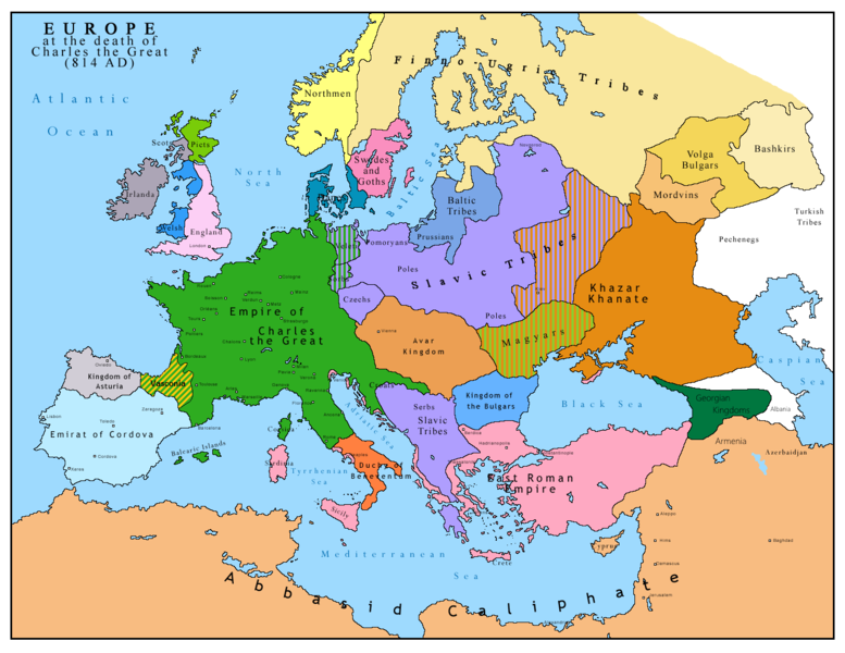
English: Map of Europe after the death of Charles the Great (814 AD). Original map made by Charles Colbeck, The Public Schools Historical Atlas (1905). |
|||
| Ημερομηνία | 2009-04-15. Source date: 1905 by Longmans, Green; New York, London, Bombay 1905. | |||
| Πηγή | Own work based on: Europe 814.jpg | |||
| Δημιουργός | Bukkia (συζήτηση · Συνεισφορά) | |||
| άλλες εκδόσεις |
|


Αδειοδότηση
[επεξεργασία]
| Εγώ, ο κάτοχος των πνευματικών δικαιωμάτων αυτού του έργου, δημοσιεύω αυτό το έργο ως κοινό κτήμα. Αυτό ισχύει σε παγκόσμια κλίμακα. Σε ορισμένες χώρες αυτό μπορεί να μην είναι νομικά εφικτό. Αν ναι: Παραχωρώ σε οποιονδήποτε το δικαίωμα να χρησιμοποιήσει αυτό το έργο "για οποιονδήποτε σκοπό", χωρίς κανέναν όρο, εκτός και αν τέτοιοι όροι τίθενται από την νομοθεσία |
_en.png)
.png)
.jpg)
Ιστορικό αρχείου
Πατήστε σε μια ημερομηνία/ώρα για να δείτε το αρχείο όπως εμφανιζόταν εκείνη την χρονική στιγμή.
| Ημερομηνία/Ώρα | Μικρογραφία | Διαστάσεις | Χρήστης | Σχόλιο | |
|---|---|---|---|---|---|
| τρέχον | 11:09, 26 Απριλίου 2023 | | 1.393 × 1.075 (169 KB) | OrionNimrod (συζήτηση | Συνεισφορά) | Reverted to version as of 13:52, 23 December 2015 (UTC) restore |
| 16:09, 2 Μαΐου 2019 |  | 1.370 × 1.047 (124 KB) | Julieta39 (συζήτηση | Συνεισφορά) | Slavs also in the Avars and Bulgars kingdoms | |
| 13:52, 23 Δεκεμβρίου 2015 |  | 1.393 × 1.075 (169 KB) | Ercwlff (συζήτηση | Συνεισφορά) | at that time armenia was already part of Arab caliphate.. and there were several Georgian kingdoms or principalities in the north of them | |
| 13:52, 8 Ιουνίου 2015 |  | 1.393 × 1.075 (157 KB) | Zorion (συζήτηση | Συνεισφορά) | Vasconia in rebellion | |
| 17:49, 28 Μαΐου 2015 |  | 1.393 × 1.075 (156 KB) | Zorion (συζήτηση | Συνεισφορά) | From 812 to 824, Vasconia was ruled by Vascons (sourced can be found anywhere in spanish, basque or french). This map was wrong for that specific year. Seems that historian wanted to credit a famous king but, he was dead when Wasconia got back under th... | |
| 15:58, 24 Αυγούστου 2014 |  | 1.393 × 1.075 (230 KB) | Martin H. (συζήτηση | Συνεισφορά) | Reverted to version as of 14:53, 31 January 2010: File is consistent with its source file File:Europe 814.jpg; change conflicts with en:Duchy_of_Vasconia#Carolingian duchy (769–864) | |
| 14:42, 24 Αυγούστου 2014 |  | 1.393 × 1.075 (156 KB) | Zorion (συζήτηση | Συνεισφορά) | Vasconia was independant from frankish kingdom until 824 | |
| 14:53, 31 Ιανουαρίου 2010 |  | 1.393 × 1.075 (230 KB) | Bukkia (συζήτηση | Συνεισφορά) | == {{int:filedesc}} == {{Information |Description={{it|1=Mappa dell'Europa alla morte di Carlo Magno (814 d.C.)}} {{en|1=Map of Europe after the death of Charles the Great (814 AD, in Italian)}} |Source=Based on File:Europe 814.jpg |Author=[[user:Buk |
Δεν μπορείτε να αντικαταστήσετε αυτό το αρχείο.
Χρήση αρχείου
Οι ακόλουθες 6 σελίδες χρησιμοποιούν προς αυτό το αρχείο:
Καθολική χρήση αρχείου
Τα ακόλουθα άλλα wiki χρησιμοποιούν αυτό το αρχείο:
- Χρήση σε arz.wikipedia.org
- Χρήση σε bo.wikipedia.org
- Χρήση σε da.wikipedia.org
- Χρήση σε de.wikipedia.org
- Χρήση σε el.wikipedia.org
- Χρήση σε en.wikipedia.org
- Χρήση σε es.wikipedia.org
- Χρήση σε fa.wikipedia.org
- Χρήση σε fr.wikipedia.org
- Χρήση σε gl.wikipedia.org
- Χρήση σε he.wikipedia.org
- Χρήση σε hu.wikipedia.org
- Χρήση σε hy.wikipedia.org
- Χρήση σε id.wikipedia.org
- Χρήση σε it.wikipedia.org
- Χρήση σε ko.wikipedia.org
- Χρήση σε lmo.wikipedia.org
- Χρήση σε lv.wikipedia.org
- Χρήση σε mk.wikipedia.org
- Χρήση σε pl.wikipedia.org
- Χρήση σε ro.wikipedia.org
- Χρήση σε sh.wikipedia.org
- Χρήση σε sr.wikipedia.org
- Χρήση σε sw.wikipedia.org
- Χρήση σε uk.wikipedia.org
Μεταδεδομένα
Κατηγορίες:
- Territorial evolution of Europe
- Maps of Eurasian Avars
- Avar Khaganate
- Maps of Slavic tribes
- Maps of the prehistory of Hungary
- Maps of the history of Romania in the Middle Ages
- Maps of the history of Chuvashia
- Maps of the history of Tatarstan
- Maps of the history of Bashkortostan
- Maps of the history of Mordovia
- Maps showing the 810s
- Maps of Khazar Khaganate
- Rus' people