File:Europe orthographic Caucasus Urals boundary.svg

Originaldatei (SVG-Datei, Basisgrößi: 537 × 536 Pixel, Dateigrößi: 77 KB)
Bildtexte
Kurzbeschreibungen
Bschryybig
[ändere]| BschryybigEurope orthographic Caucasus Urals boundary.svg |
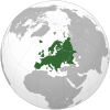
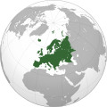
English: Map of Europe. The continental boundary to Asia as indicated is the standard convention following the Caucasus crest, the Ural River and the Urals Mountains to the Sea of Kara
العربية: الخريطة الهجائية لأوروبا |
||||
| Datum | |||||
| Quälle |
Diese Datei wurde von diesem Werk abgeleitet: Europe (orthographic projection).svg:  von Ssolbergj von Ssolbergj |
||||
| Urheber | abgeleitetes Werk von Dbachmann | ||||
| Anderi Versione |
|
||||
| SVG‑Erstellung InfoField |
|
Lizänzierig
[ändere]| Public domainPublic domainfalsefalse |
| This map is ineligible for copyright and therefore in the public domain, because it consists entirely of information that is common property and contains no original authorship. For more information, see Commons:Threshold of originality § Maps.
English | Español | Galego | Română | slovenščina | العربية | 简体中文 | 繁體中文 | +/− |
Orginal Logbuech vu uffegladene Datei
[ändere]This image is a derivative work of the following images:
- Europe (orthographic projection).svg licensed with Cc-by-sa-3.0, GFDL, GFDL-GMT
- 2011-04-04T18:44:34Z Green, White and Gold 541x541 (240232 Bytes) Reverted to version as of 22:37, 8 July 2009
- 2011-04-03T04:49:43Z ComtesseDeMingrelie 541x541 (240232 Bytes) correcting [[:en:Rioni river|Phasis]] riverbank
- 2011-04-03T04:49:20Z ComtesseDeMingrelie 541x541 (240232 Bytes) more common
- 2011-04-03T04:44:12Z ComtesseDeMingrelie 541x541 (240232 Bytes) most common definition
- 2009-07-08T22:37:54Z Bosonic dressing 541x541 (245157 Bytes) rv: yes - per Natl Geographic Atlas of the World, which trumps what might be an original concoction
- 2009-07-05T13:50:15Z Ssolbergj 541x541 (240232 Bytes) I based the border on http://en.wikipedia.org/wiki/File:Map_of_Europe_(political).png. Do you have a more reliable source?
- 2009-06-20T19:08:43Z Bosonic dressing 541x541 (245157 Bytes) Europe: orthographic projection - minor tweak of continental border in Caucasus
- 2009-01-07T02:40:28Z Ssolbergj 541x541 (240232 Bytes) {{Information |Description={{en|1=Europe}} |Source=Own work, [http://www.aquarius.geomar.de/omc/make_map.html Aquarius.geomar.de]{{GFDL-GMT}} |Author=[[User:Ssolbergj|Ssolbergj]] |Date=7 January 2009 |Permission=
Hochgeladen mit derivativeFX
Dateiversione
Klick uf e Zytpunkt zu aazeige, wie s dert usgsäh het.
| Version vom | Vorschaubild | Mäß | Benutzer | Kommentar | |
|---|---|---|---|---|---|
| aktuell | 13:32, 4. Sep. 2022 |  | 537 × 536 (77 KB) | M.Bitton (Diskussion | Byträg) | Reverted to version as of 12:03, 4 September 2022 (UTC): per COM:OVERWRITE |
| 13:30, 4. Sep. 2022 |  | 537 × 536 (177 KB) | Рагин1987 (Diskussion | Byträg) | Small correction | |
| 12:03, 4. Sep. 2022 |  | 537 × 536 (77 KB) | M.Bitton (Diskussion | Byträg) | Reverted to version as of 05:48, 12 March 2019 (UTC): per COM:OVERWRITE + fake svg | |
| 19:12, 30. Aug. 2022 |  | 2.052 × 2.048 (874 KB) | Рагин1987 (Diskussion | Byträg) | More correct visualization of the dividing line on the territory of the Caucasus Range | |
| 05:48, 12. Mär. 2019 |  | 537 × 536 (77 KB) | AndreyKva (Diskussion | Byträg) | Optimized. | |
| 19:25, 3. Mär. 2016 |  | 537 × 536 (197 KB) | Denniss (Diskussion | Byträg) | Reverted to version as of 13:27, 19 October 2014 (UTC) | |
| 18:37, 3. Mär. 2016 |  | 537 × 536 (239 KB) | Ercwlff (Diskussion | Byträg) | UC UC UC | |
| 13:27, 19. Okt. 2014 |  | 537 × 536 (197 KB) | Deni Mataev (Diskussion | Byträg) | Again, The entirety of Georgia is not in Europe geographically, only North Eastern parts are | |
| 20:05, 18. Okt. 2014 |  | 537 × 536 (238 KB) | Politologia (Diskussion | Byträg) | Reverted to version as of 10:57, 18 October 2014 In all maps Georgia is part of Georgia. There is at list 10 versions of borders of Europe in most of them Georgia is part of Europa | |
| 20:04, 18. Okt. 2014 |  | 537 × 536 (238 KB) | Politologia (Diskussion | Byträg) | Reverted to version as of 10:57, 18 October 2014 In all maps Georgia is part of Georgia. |
Du chasch die Datei nit iberschryybe.
Verwändig vu dr Datei
Meh wie 100 Syte verwyyse uf die Datei. Die Lischt zeigt nume di erschte 100 Link uf die Datei. E vollständigi Lischt isch verfiegbar.
- Grey–green orthographic projections maps
- User:Heraldry/Projections
- User:Ssolbergj/orthographic
- File:ALBA (orthographic projection).png
- File:Africa (orthographic projection).svg
- File:African Union (orthographic projection).svg
- File:Almoravid map.svg
- File:America do Sul (orthographic projection).jpg
- File:Americas (orthographic projection).svg
- File:Andean Community (orthographic projection).svg
- File:Antarctica (orthographic projection).svg
- File:Antillas (orthographic projection).svg
- File:Arctic (orthographic projection).svg
- File:Argentina (orthographic projection).png
- File:Argentina (orthographic projection).svg
- File:Aridoamerica (orthographic projection).svg
- File:Armenia (orthographic projection).svg
- File:Asia (orthographic projection).svg
- File:Association of Southeast Asian Nations (orthographic projection).svg
- File:Australia-New Guinea (orthographic projection).svg
- File:Australia (orthographic projection).svg
- File:Australia map with outlying islands.svg
- File:Bhutan (orthographic projection).svg
- File:Brazil (orthographic projection).svg
- File:CECAFA-Map.svg
- File:Canada (orthographic projection).svg
- File:Cape Verde (orthographic projection).svg
- File:Captaincy General of Chile (orthographic projection).svg
- File:Central America (orthographic projection).svg
- File:Central Asia (orthographic projection).svg
- File:Chile (orthographic projection).svg
- File:Colombia (orthographic projection).svg
- File:Democratic Republic of the Congo (orthographic projection).svg
- File:Denmark (orthographic projection).svg
- File:Dominion of Pakistan & Indian Controlled Kashmir (orthographic projection).svg
- File:East Asia (orthographic projection).svg
- File:Ecuador (orthographic projection).svg
- File:Europe (orthographic projection).svg
- File:European Union (orthographic projection).svg
- File:Federal Republic of Central America (orthographic projection).svg
- File:First Brazilian Empire (orthographic projection).svg
- File:First Mexican Empire (orthographic projection).svg
- File:Georgia (orthographic projection).svg
- File:Germany (orthographic projection).svg
- File:Global European Union.svg
- File:Great Colombia (orthographic projection).svg
- File:Greater Middle East (orthographic projection).svg
- File:Haiti (orthographic projection).svg
- File:India (orthographic projection).svg
- File:Indonesia (orthographic projection).svg
- File:Iran (orthographic projection).svg
- File:Iraq (orthographic projection).svg
- File:Jamaica (orthographic projection).svg
- File:Japan (orthographic projection).svg
- File:Kazakhstan (orthographic projection).svg
- File:Latin America (orthographic projection).svg
- File:Lusophone America (orthographic projection).svg
- File:MERCOSUR (orthographic projection).svg
- File:Madagascar (orthographic projection).svg
- File:Maghreb (orthographic projection).svg
- File:Malaysia (orthographic projection).svg
- File:Mayan languages (orthographic projection).svg
- File:Mesoamerica (orthographic projection) with borders.svg
- File:Mexico (orthographic projection).svg
- File:Mexico and Central America (orthographic projection).svg
- File:Middle East (orthographic projection).svg
- File:Mongolia (orthographic projection).svg
- File:New Spain (orthographic projection).svg
- File:New Zealand (orthographic projection).svg
- File:Nigeria (orthographic projection).svg
- File:North Africa (orthographic projection).svg
- File:North America (orthographic projection).svg
- File:North American Agreement (orthographic projection).svg
- File:North Korea (orthographic projection).svg
- File:Papua New Guinea (orthographic projection).svg
- File:Paraguay (orthographic projection).svg
- File:People's Republic of China (orthographic projection).svg
- File:Peru (orthographic projection).svg
- File:Peru–Bolivia Confederation (orthographic projection).svg
- File:Philippines (orthographic projection).svg
- File:Republic of Artsakh (orthographic projection).svg
- File:Republic of China (orthographic projection).svg
- File:Rio Group (orthographic projection).svg
- File:Roman Empire (orthographic projection).svg
- File:Russian Federation (orthographic projection).svg
- File:Second Mexican Empire (orthographic projection).svg
- File:South Asia (orthographic projection) without national boundaries.svg
- File:South Korea (orthographic projection).svg
- File:Southern Europe (orthographic projection).svg
- File:Tawantinsuyu (orthographic projection).svg
- File:The Philippines and ASEAN (orthographic projection).svg
- File:Third Reich (orthographic projection).svg
- File:Tunisia (orthographic projection).svg
- File:Turkey (orthographic projection).svg
- File:Union of South American Nations (orthographic projection).svg
- File:Union of Soviet Socialist Republics (orthographic projection).svg
- File:United Provinces of Central America (orthographic projection).svg
- File:Venezuela (orthographic projection).svg
- File:Viceroyalty of Peru (orthographic projection).svg
- File:Viceroyalty of the Río de la Plata (orthographic projection).svg
Meh Links fir die Datei.
Wältwyti Dateinutzig
Die andere Wikis bruche die Datei:
- Gebruch uf ab.wikipedia.org
- Gebruch uf ace.wikipedia.org
- Gebruch uf ady.wikipedia.org
- Gebruch uf af.wikipedia.org
- Gebruch uf ar.wikipedia.org
- بوابة:آسيا
- بوابة:أوروبا
- بوابة:إفريقيا
- بوابة:القارة القطبية الجنوبية
- بوابة:القارة القطبية الجنوبية/بوابات شقيقة
- قائمة جوازات السفر
- بوابة:تركيا
- بوابة:تركيا/بوابات شقيقة
- بوابة:جغرافيا/مقالة مختارة/أرشيف
- المرأة في تركيا
- بوابة:أوروبا/واجهة
- بوابة:تصفح
- بوابة:تصفح/جغرافيا
- قائمة مفاتيح الاتصال الدولية
- المرأة في ألمانيا
- بوابة:إسطنبول
- بوابة:آسيا/بوابات شقيقة
- ويكيبيديا:مقالة الصفحة الرئيسية المختارة/398
- بوابة:جغرافيا/مقالة مختارة/21
- معاملة المثليين في أوروبا
- المرأة في أوروبا
- المرأة في البرتغال
- المرأة في فنلندا
- المرأة في مقدونيا الشمالية
- المرأة في ترانسنيستريا
- المرأة في الفاتيكان
- المرأة في أذربيجان
- المرأة في اليونان
- المرأة في ألبانيا
- المرأة في إيطاليا
- المرأة في الجبل الأسود
Wältwyti Verwändig vu däre Datei aaluege.
Metadate
Die Datei het wyteri Informatione, allwäg vor Digitalkamera oder vom Scanner wo se het gschaffe.
We die Datei isch veränderet worde, de cha's sy, das die zuesätzlechi Information für di verändereti Datei nümm richtig zuetrifft.
| Breiti | 536.58 |
|---|---|
| Längi | 536.395 |
