File:European Union Iceland Locator.svg
跳至導覽
跳至搜尋

此 SVG 檔案的 PNG 預覽的大小:587 × 600 像素。 其他解析度:235 × 240 像素 | 470 × 480 像素 | 752 × 768 像素 | 1,002 × 1,024 像素 | 2,004 × 2,048 像素 | 593 × 606 像素。
原始檔案 (SVG 檔案,表面大小:593 × 606 像素,檔案大小:711 KB)
說明
說明
添加單行說明來描述出檔案所代表的內容
摘要
[編輯]| 描述 |
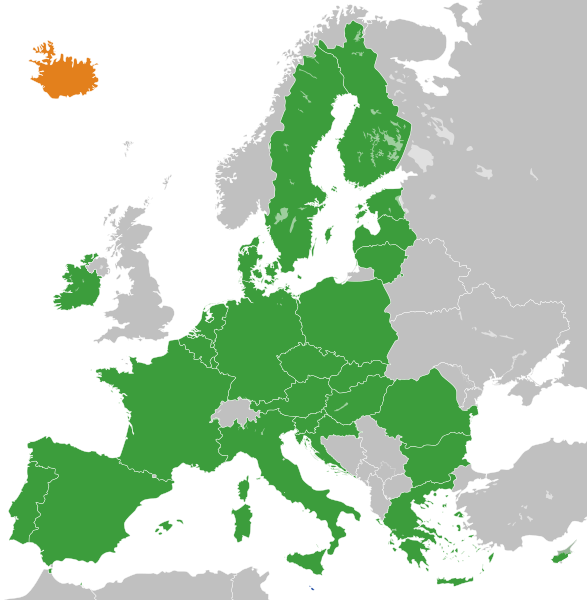
English: The European Union and Iceland
Français : L'Union Européenne à 28 sans ses frontières internes et l'Islande.
Islande
UE à 28 |
| 日期 | |
| 來源 |
自己的作品 |
| 作者 | S. Solberg J. |
| 其他版本 |
|
.svg)
授權條款
[編輯]
| 我,此作品的版權所有人,釋出此作品至公共領域。此授權條款在全世界均適用。 這可能在某些國家不合法,如果是的話: 我授予任何人有權利使用此作品於任何用途,除受法律約束外,不受任何限制。 |
檔案歷史
點選日期/時間以檢視該時間的檔案版本。
| 日期/時間 | 縮圖 | 尺寸 | 使用者 | 備註 | |
|---|---|---|---|---|---|
| 目前 | 2022年11月20日 (日) 13:40 | | 593 × 606(711 KB) | M.Bitton(留言 | 貢獻) | Reverted to version as of 01:53, 19 November 2022 (UTC): per COM:OVERWRITE. 2016 was 6 years ago, making this map stable. Feel free to upload under a different name |
| 2022年11月20日 (日) 09:00 |  | 593 × 606(714 KB) | Рагин1987(留言 | 貢獻) | Removed the gray square at the maritime borders of Spain, also painted over Malta from blue to green (also a member of the EU). Slightly expanded the map to the borders of Georgia (the territory of Abkhazia), since Georgia, like Moldova, is a member of the Eastern Partnership, an associated trio and applied for EU membership. Please, before automatically referring to COM:OVERWRITE, take a close look at the history of the file, and the fact that its format was radically edited in 2016. | |
| 2022年11月19日 (六) 01:53 |  | 593 × 606(711 KB) | M.Bitton(留言 | 貢獻) | Reverted to version as of 12:05, 3 February 2020 (UTC): meaningless edit summary | |
| 2022年11月18日 (五) 12:54 |  | 593 × 606(710 KB) | Рагин1987(留言 | 貢獻) | Small correction | |
| 2020年2月3日 (一) 12:05 |  | 593 × 606(711 KB) | Darranc(留言 | 貢獻) | Remove UK from EU | |
| 2016年10月26日 (三) 18:21 |  | 680 × 520(602 KB) | Giorgi Balakhadze(留言 | 貢獻) | Rv of sockpuppet and per COM:OVERWRITE | |
| 2015年3月15日 (日) 21:00 |  | 680 × 520(620 KB) | Leftcry(留言 | 貢獻) | Update layout | |
| 2013年7月11日 (四) 10:51 |  | 680 × 520(307 KB) | Augusta 89(留言 | 貢獻) | Croatie (oubli) | |
| 2013年7月11日 (四) 10:13 |  | 680 × 520(309 KB) | Augusta 89(留言 | 貢獻) | Localisation des micro-États européens | |
| 2013年7月1日 (一) 09:23 |  | 680 × 520(318 KB) | Treehill(留言 | 貢獻) | + croatia |
無法覆蓋此檔案。
檔案用途
全域檔案使用狀況
以下其他 wiki 使用了這個檔案:
- de.wikipedia.org 的使用狀況
- en.wikipedia.org 的使用狀況
- en.wikinews.org 的使用狀況
- es.wikinews.org 的使用狀況
- fr.wikipedia.org 的使用狀況
- fr.wikinews.org 的使用狀況
- it.wikipedia.org 的使用狀況
- mk.wikipedia.org 的使用狀況
- pl.wikipedia.org 的使用狀況
- sv.wikipedia.org 的使用狀況
- tr.wikinews.org 的使用狀況
- uk.wikipedia.org 的使用狀況
- www.wikidata.org 的使用狀況
- zh.wikipedia.org 的使用狀況