File:Extent of the Roman Republic and the Roman Empire between 218 BC and 117 AD.png
Salta a la navegació
Salta a la cerca
Mida d'aquesta previsualització: 800 × 500 píxels. Altres resolucions: 320 × 200 píxels | 640 × 400 píxels | 1.024 × 640 píxels | 1.280 × 800 píxels | 2.850 × 1.781 píxels.
Fitxer original (2.850 × 1.781 píxels, mida del fitxer: 3,9 Mo, tipus MIME: image/png)
Llegendes
Llegendes
Afegeix una explicació d'una línia del que representa aquest fitxer
Resum
[modifica]
| Descripció |
Asturianu: L'Kinans Empire
nel 133 BC (d'escuru y colloráu).
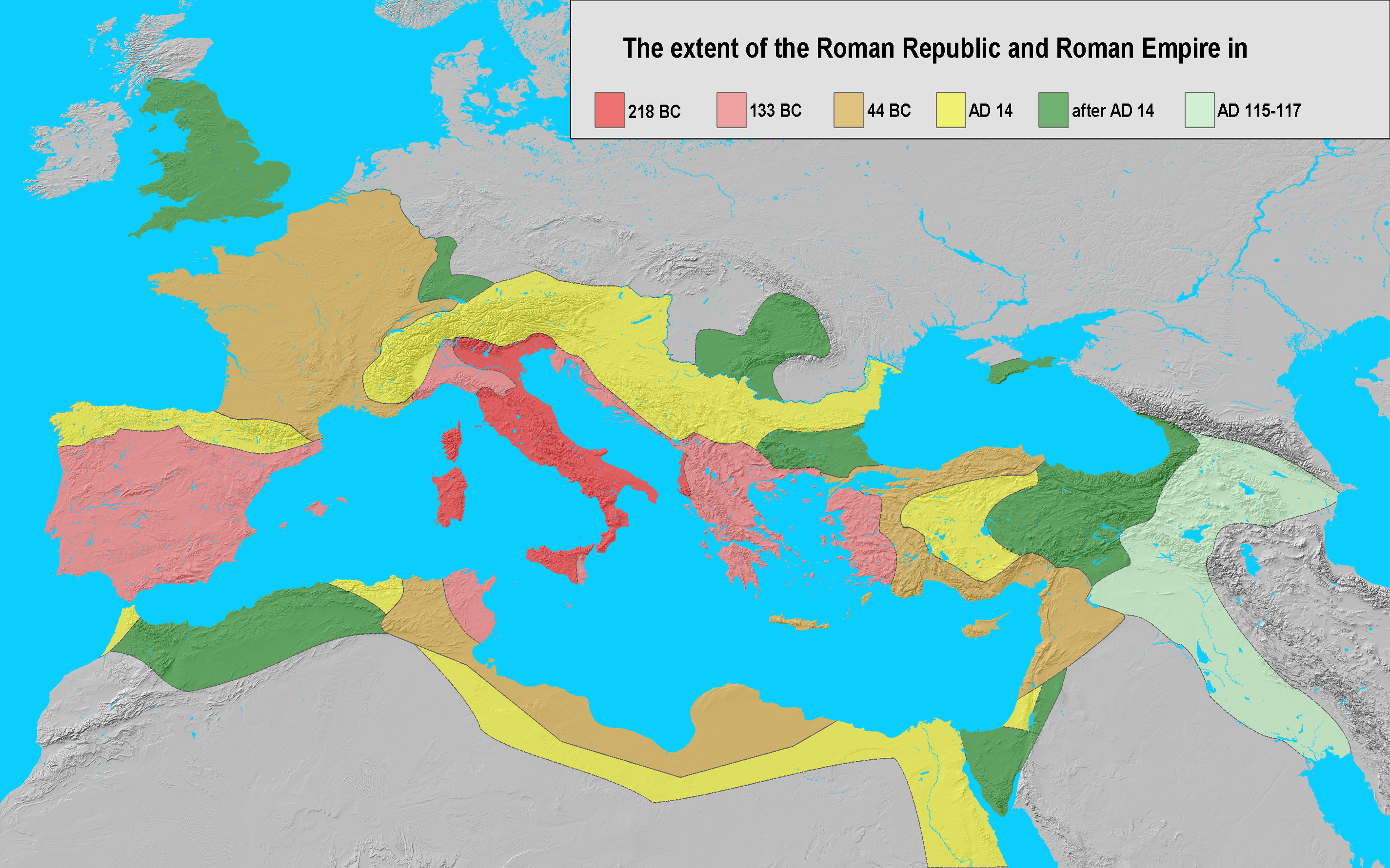
Català: Expansió de l'Imperi Romà el 218 a.C. (vermell), 133 a.C. (rosa), 44 a.C. (taronja), 14 d.C. (groc), i 117 d.C. (verd).
Cymraeg: Yr Ymerodraeth Rufeinig yn 14 (pob lliw heblaw gwyrdd a llwyd).
English: Extent of the Roman Republic (509 BC–27 BC) and Roman Empire (27 BC–476/1453 AD) in 218 BC (dark red), 133 BC (light red), 44 BC (orange), 14 AD (yellow), after 14 AD (green) and maximum extension under Trajan 117 (light green).
Español: Expansión del Imperio Romano en 218 (rojo), 133 (rosa), 44 a.C. (naranja), 14 (amarillo), y 117 (verde). Suomi: Rooman valtakunta 44 eaa.
Français : Évolution des territoires contrôlés par l'Empire romain jusqu'à sa chute en 476.
Galego: Expansión do Imperio Romano en 133 a.dC. (vermello), 44 a-dC. (laranxa), 14 (amarelo), e 117 (verde). A extensión da república romana en 218 a. C. (vermello oscuro), 133 a. C. (rosado), 44 a. C. (laranxa), 14 d. C. ( amarelo), despoís 14 d. C. (verde) e unha extensión máxima baixo o gobierno de Trajano, 117 d. C. (verde claro).
客家語/Hak-kâ-ngî:Lò-mâ Ti-koet.
Italiano: Fasi dell'espansionismo romano dal 218 a.C. al 117 d.C..
日本語: 紀元前44年頃のローマ帝国の範囲.
한국어: 로마제국은 북쪽으로는 브리타니아, 남쪽으로는 팔레스타인 지역까지 영토를 확장하였다.
Nederlands: De groei van het Romeinse Rijk tijdens de late republiek en het vroege principaat; ██ 218 v.Chr. (voor de Tweede Punische Oorlog) ██ 133 v.Chr. (begin van onrust in de republiek) ██ 44 v.Chr. (dood van Julius Caesar) ██ 14 v.Chr. (tijdens het principaat van Augustus) ██ uitbreidingen in de eerste eeuw n.Chr. ██ 114-117 n.Chr. (tijdelijke uitbreiding onder Trajanus).
Piemontèis: Surfasse dla Repùblica e dl'Imperi dël 218 aGC (ross ëscur), 133 aGC (reusa), 44 aGC (groson), 14 dGC (giàun), dapress al 14 dGC (vèrd), e surfassa màssima sot a Trajan, 117 dGC (vërzolin).
Русский: Земли Римской Республики (509–27 до н.э.) и Римской Империи (27 до н.э. –476/1453 н.э.) в 218 г. до н.э. (темно красный), 133 г. до н.э. (светло красный), 44 г. до н.э. (оранжевый), 14 г. н.э. (желтый), после 14 г н.э. (зеленый) и достигшие максимума при Траяне в 117 г. н.э. (светло зеленый).
Srpskohrvatski / српскохрватски: Rimska država godine 44. pne. (označeno svjetlocrvenom, tamnocrvenom i narančastom bojom). Rimske teritorije godine 218. pne. (tamnocrveno). Rimska Republika godine 133. pne. (područja označena crveno i svjetlocrveno). Rimsko Carstvo godine 14. n.e. (sve boje osim zelene i sive).
Simple English: The extent of the Roman Republic and Roman Empire in 218 BC (dark red), 133 BC (light red), 44 BC (orange), AD 14 (yellow), after AD 14 (green), and maximum extension under Trajan 117 (light green).
Српски / srpski: Римска република и Римско царство: 215. п. н. е. (тамно црвено),133. п. н. е. (свијетло црвено), 44. п. н. е. (оранж), 14 н. ере (жуто), даља освајања (зелено) и Трајанова освајања на истоку (свијетло зелено).
Svenska: Romerska riket 14 e.Kr. (alla färger utom mörk- och ljusgrönt samt grått). Romerska riket 44 f.Kr. (i mörk- och ljusrött samt oranget). Romerska republiken 218 f.Kr. (i mörkrött). Romerska riket 133 f.Kr. (i mörk- och ljusrött).
தமிழ்: கிமு 44 இல் ரோமன் பேரரசு (கடும், இளம் சிவப்பு மற்றும் செம்மஞ்சள் நிறத்தில் காட்டப்பட்டுள்ளது.). |
| Data | |
| Font | own work; base map from Natural Earth |
| Autor | Varana |
| Permís (Com reutilitzar aquest fitxer) |
GDFL, CC-BY-SA |

|
Aquesta imatge (de tipus historical map) s'hauria de tornar a crear utilitzant gràfics vectorials com ara un fitxer SVG. Això té diversos avantatges; en trobareu més informació a Commons:Media for cleanup. Si ja disposeu d'una versió d'aquesta imatge en format SVG, us preguem que la pengeu; després, reemplaceu aquesta plantilla amb la plantilla {{Vector version available|nom nou de la imatge.svg}} en aquesta imatge.
|
Llicència
[modifica]
Jo, el titular dels drets d'autor d'aquest treball, el public sota les següents llicències:

|
S'autoritza la còpia, la distribució i la modificació d'aquest document sota els termes de la llicència de documentació lliure GNU versió 1.2 o qualsevol altra versió posterior que publiqui la Free Software Foundation; sense seccions invariants, ni textos de portada, ni textos de contraportada. S'inclou una còpia d'aquesta llicència en la secció titulada GNU Free Documentation License. |
| Aquest fitxer està subjecte a la llicència de Creative Commons Reconeixement i Compartir Igual 3.0 No adaptada. | ||
| ||
| Aquest avís de llicència s'ha afegit a aquest fitxer d'acord amb l'actualització de la llicència GFDL. |
Aquest fitxer està llicenciat sota les llicències de Creative Commons Reconeixement - CompartirIgual 2.5 Genèrica, 2.0 Genèrica i 1.0 Genèrica.
- Sou lliure de:
- compartir – copiar, distribuir i comunicar públicament l'obra
- adaptar – fer-ne obres derivades
- Amb les condicions següents:
- reconeixement – Heu de donar la informació adequada sobre l'autor, proporcionar un enllaç a la llicència i indicar si s'han realitzat canvis. Podeu fer-ho amb qualsevol mitjà raonable, però de cap manera no suggereixi que l'autor us dóna suport o aprova l'ús que en feu.
- compartir igual – Si modifiqueu, transformeu, o generareu amb el material, haureu de distribuir les vostres contribucions sota una llicència similar o una de compatible com l'original
Podeu seleccionar la llicència que vulgueu.
Historial del fitxer
Cliqueu una data/hora per veure el fitxer tal com era aleshores.
| Data/hora | Miniatura | Dimensions | Usuari/a | Comentari | |
|---|---|---|---|---|---|
| actual | 12:01, 26 oct 2011 | | 2.850 × 1.781 (3,9 Mo) | Alexander Vigo (discussió | contribucions) | Correction in the northwestern Iberian peninsula. The Decimus Junius Brutus Callaicus´ expedition (137 B.C) arrived only to river Miño. |
| 18:35, 4 gen 2008 |  | 2.850 × 1.781 (3,99 Mo) | EliasAlucard~commonswiki (discussió | contribucions) | corrected aspect ratio | |
| 09:21, 25 nov 2006 |  | 2.850 × 1.500 (3,01 Mo) | Varana (discussió | contribucions) | == Beschreibung == {{Information |Description=Extent of the Roman Empire in 218 BC (dark red), 133 BC (light red), 44 BC (orange), AD 14 (yellow), later acquisitions (green) and Trajan's Eastern conquests (light green). |Source=own work; base map from [ht | |
| 19:41, 24 nov 2006 |  | 2.850 × 1.500 (3,01 Mo) | Varana (discussió | contribucions) | {{Information |Description=Extent of the Roman Empire in 218 BC (dark red), 133 BC (light red), 44 BC (orange), AD 14 (yellow), later acquisitions (green) and Trajan's Eastern conquests (light green). |Source=own work; base map from [http://www.shadedreli |
No podeu sobreescriure aquest fitxer.
Ús del fitxer
Les 3 pàgines següents utilitzen aquest fitxer:
- Atlas of the Levant
- Atlas of the antiquity
- File:RomanEmpire Phases.png (fitxer redirigit)
Ús global del fitxer
Utilització d'aquest fitxer en altres wikis:
- Utilització a ar.wikipedia.org
- Utilització a ast.wikipedia.org
- Utilització a bn.wikipedia.org
- Utilització a ca.wikipedia.org
- Utilització a cs.wikipedia.org
- Utilització a cy.wikipedia.org
- Utilització a de.wikipedia.org
- Utilització a en.wikipedia.org
- AD 14
- 44 BC
- 133 BC
- Classical antiquity
- Talk:Roman Empire/Archive 4
- History of Roman-era Tunisia
- Wikipedia:Wikipedia Signpost/2013-05-20/WikiProject report
- Wikipedia:Wikipedia Signpost/Single/2013-05-20
- User:Fuzzycatty/sandbox
- User:Fuzzycatty/HellenizationInFirstCenturyJudea
- User:Falcaorib/Ancient Empires (01 AD-150 AD)
- Utilització a es.wikipedia.org
- Utilització a et.wikipedia.org
- Utilització a eu.wikipedia.org
- Utilització a fi.wikipedia.org
- Utilització a fr.wikipedia.org
- Utilització a gl.wikipedia.org
- Utilització a hak.wikipedia.org
- Utilització a he.wikipedia.org
- Utilització a hy.wikipedia.org
- Utilització a id.wikipedia.org
- Utilització a it.wikipedia.org
- Utilització a ja.wikipedia.org
- Utilització a ko.wikipedia.org
- Utilització a lv.wikipedia.org
- Utilització a ms.wikipedia.org
- Utilització a nl.wikipedia.org
- Utilització a nl.wikibooks.org
- Utilització a no.wikipedia.org
- Utilització a pms.wikipedia.org
- Utilització a pnb.wikipedia.org
- Utilització a ru.wikipedia.org
Vegeu més usos globals d'aquest fitxer.